CamVox
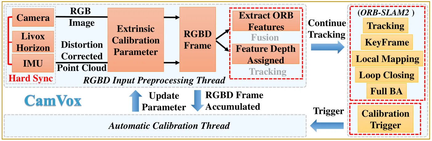
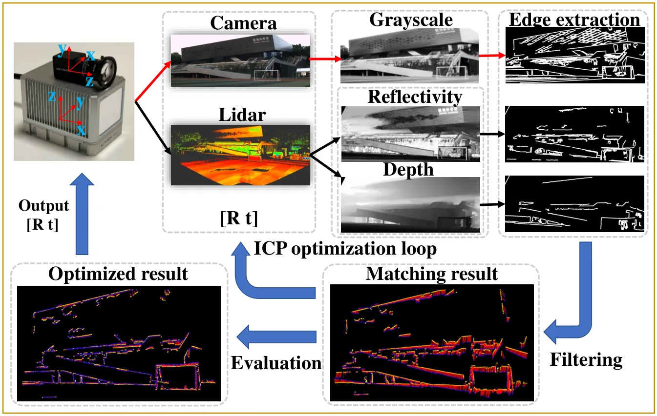
CamVox 把低成本的 Livox Horizon 固態 LiDAR 當作 ORB-SLAM2 的深度感測器:LiDAR 點先以 IMU 依各點時間校正運動畸變並轉到相機觸發時刻,再投影成與彩色影像逐像素對應的深度圖,組成 RGB-D 影格交給 ORB-SLAM2 的追蹤、局部建圖與迴圈閉合;由於 LiDAR 可量到上百公尺,深度小於 130 m 的特徵都視為近點。系統另利用 Livox 非重複掃描在靜止數秒後即可累積成高密度影像的特性,比對相機影像與 LiDAR 反射強度及深度影像的邊緣,於機器人靜止時自動做無標靶外參校正。
本頁內容
Uses a Livox Horizon non-repeating-scan LiDAR as the depth sensor of ORB-SLAM2 RGB-D mode (IMU-deskewed points projected to a depth image aligned with the camera, close-keypoint threshold raised to 130 m) and adds targetless automatic LiDAR-camera calibration by edge matching of accumulated reflectivity and depth images while the robot is stationary.
技術屬性
欄位內容為文獻擷取紀錄的原文用語(英文),以原文為據;「未查證」表示本研究尚未讀到該資訊,不代表該方法不具備此能力。
| 感測輸入 | monocular rolling-shutter camera (MV-CE060-10UC)、solid-state non-repeating-scan LiDAR (Livox Horizon)、IMU (Inertial Sense uINS) used only for LiDAR motion distortion correction |
|---|---|
| 原文測試平台 | wheeled UGV (AgileX Scout mini robot platform) |
| 狀態估計 | ORB-SLAM2 in RGB-D mode: tracking, local mapping with local bundle adjustment, loop closing and full bundle adjustment of ORB-SLAM2, fed with RGB-D frames built from the camera image and a depth image projected from IMU-corrected Livox points; keypoints with LiDAR depth below 130 m are treated as close points (Sec. III) |
| 資料關聯 | ORB features on the camera image with depth from the projected LiDAR depth image; extrinsic calibration by edge matching between the camera image and LiDAR reflectivity and depth images (Canny edges, edges shorter than 200 pixels and cluttered interior edges removed), a K-D-tree ICP cost with a mismatch penalty, and coordinate descent over roll, pitch and yaw in Ceres (Sec. III-C, Eq. 3 in the IEEE version) |
| 時間表示 | discrete RGB-D frames at the 10 Hz hardware trigger; each LiDAR point transformed with the IMU pose at its timestamp to the LiDAR frame at the trigger time (Sec. III-B) |
| 去畸變 | IMU-based correction of each LiDAR point to the trigger time of the camera image; IMU at 200 Hz synchronized with the trigger (Sec. III-A, III-B); the IEEE version describes the correction as partial |
| 迴圈閉合 | yes, ORB-SLAM2 loop closing (Sec. III; Fig. 4; Table II) |
| 全域最佳化 | ORB-SLAM2 pose-graph optimization and full bundle adjustment after loop closure (Sec. III) |
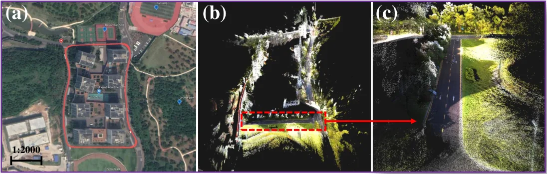
| 地圖表示 | ORB-SLAM2 keyframes and map points; dense colored point cloud (RGB-D map) reconstructed from the frames for visualization (Fig. 1) |
| 先驗資訊 | initial LiDAR-camera extrinsic refined by the automatic calibration thread when the robot is stationary; camera intrinsics assumed known (Sec. III-C) |
| 可輸出幾何 | camera trajectory and a dense RGB-colored point cloud map (Fig. 1; Fig. 6 in the IEEE numbering) |
| 計算需求 | DJI Manifold 2C onboard computer with a 4-core Intel Core i7-8550U; real time; tracking 42.27 ms, mapping 252.41 ms, loop closing 7821.22 ms, IMU correction 0.89 ms and point-cloud-to-depth 16.35 ms per call; automatic calibration about 58 s, run only when stationary (Sec. IV-D; Table II) |
使用設備
原文使用的感測器、運算硬體與載具(equipment)。型號保留原文寫法,連結到設備頁中同一型號的歸併名稱;角色依原文用途分為方法輸入、資料集感測器、執行運算平台、參考或真值量測(reference or ground truth)與比較對象設備。
| 類別 | 型號(原文寫法) | 角色 | 資料集 | 原文規格 | 出處 |
|---|---|---|---|---|---|
| LiDAR | Livox Horizon | 方法輸入 | SUSTech dataset (CamVox) | non-repeating scan; detection up to 260 m under strong sunlight (cited spec); clock synced with GPS-RTK; sale price 800 USD | (Zhu et al., 2021, Sec. II; Sec. III-A) |
| 慣性量測單元(IMU) | Inertial Sense uINS | 方法輸入 | SUSTech dataset (CamVox) | 200 Hz, synchronized with the trigger; used for LiDAR motion correction | (Zhu et al., 2021, Sec. III-A) |
| GNSS 接收器 | Inertial Sense uINS (GPS-RTK) | 參考或真值量測 | SUSTech dataset (CamVox) | GPS-RTK recorded for ground truth | (Zhu et al., 2021, Sec. III-A) |
| 相機 | MV-CE060-10UC | 方法輸入 | SUSTech dataset (CamVox) | rolling shutter camera; outputs at each 10 Hz trigger; 1520 x 568 images used | (Zhu et al., 2021, Sec. III-A; Table II) |
| RGB-D 相機 | Intel Realsense D435歸入:Intel RealSense D435 | 比較對象設備 | 未標示 | mounted for comparison; no points beyond 10 m and sunlight noise outdoors | (Zhu et al., 2021, Sec. III-A; Sec. III-B) |
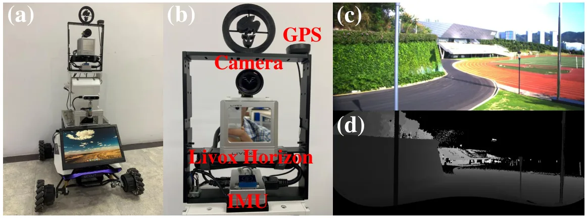
| 載具平台 | Agile X Scout mini | 方法輸入 | 未標示 | moving robot platform carrying the CamVox hardware | (Zhu et al., 2021, Sec. III-A; Fig. 3) |
| 運算硬體 | DJI Manifold 2C | 執行運算平台 | 未標示 | 4-core Intel Core i7-8550U; real-time CamVox | (Zhu et al., 2021, Sec. IV-D) |
論文圖片
只收錄原文以開放授權(open license)釋出的圖片,並依授權條件標示出處、圖號、授權與修改方式。
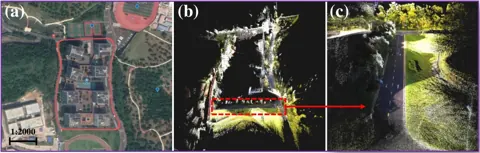
Fig. 1 (arXiv v1)CamVox 範例結果:機器人軌跡、稠密 RGB-D 彩色點雲地圖與局部放大
出處:Zhu et al., 2021,Fig. 1 (arXiv v1)。授權:CC BY 4.0。原始圖檔。修改:轉存為 WebP 格式。
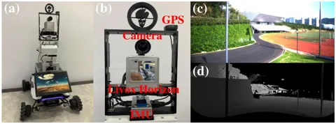
Fig. 3 (arXiv v1)完整機器人平台與 CamVox 硬體近照(相機、Livox Horizon、IMU、GPS-RTK),以及對應的彩色影像與 LiDAR 深度影像
出處:Zhu et al., 2021,Fig. 3 (arXiv v1)。授權:CC BY 4.0。原始圖檔。修改:轉存為 WebP 格式。
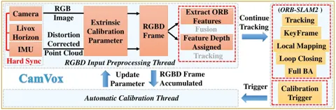
Fig. 4 (arXiv v1)CamVox SLAM 流程:ORB-SLAM2 主執行緒之外新增 RGB-D 輸入前處理執行緒與自動校正執行緒
出處:Zhu et al., 2021,Fig. 4 (arXiv v1)。授權:CC BY 4.0。原始圖檔。修改:縮小至寬度不超過 1400 px,並轉存為 WebP 格式。
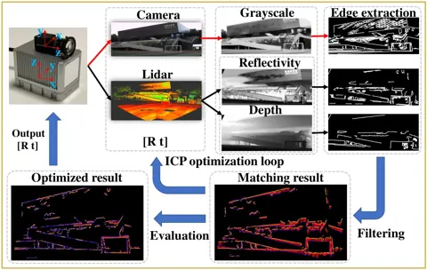
Fig. 7 (arXiv v1)自動校正流程:由靜止累積的 LiDAR 反射強度與深度影像和相機灰階影像擷取邊緣後迭代匹配
出處:Zhu et al., 2021,Fig. 7 (arXiv v1)。授權:CC BY 4.0。原始圖檔。修改:轉存為 WebP 格式。
作者報告的優勢與限制
優勢
- On the SUSTech dataset APE RMSE 1.8 m versus 7.5 m for VINS-mono and 6.5 m for livox_horizon_loam (Table I)
- Automatic calibration from a misalignment of more than 2 deg reached a cost of 6.11 versus 5.88 for the best manual calibration and worked in outdoor natural, outdoor built and underexposed indoor scenes (Sec. IV-A)
- Depth-associated feature points detected reliably beyond 100 m, whereas the RealSense RGB-D camera gave no points beyond 10 m and suffered from sunlight noise (Sec. III-B)
- Real-time operation on the onboard Manifold 2C computer (Sec. IV-D)
- Hardware, code and dataset released; the Livox Horizon sold for 800 USD versus 10k to 80k USD for similar lidars (Sec. III-A)
限制
- Loop closing takes 7821.22 ms per call on the onboard computer, far longer than in ORB-SLAM2 on TUM (598.70 ms) (Table II)
- Automatic calibration takes about 58 s and needs the robot to be stationary (Sec. IV-D)
- Only one outdoor sequence is evaluated quantitatively; ground truth is from GPS-RTK (Sec. IV-C)
- The LiDAR motion correction is described as partial in the IEEE version (Sec. III-B)
營建工程相關證據
論文只在南方科技大學校園的戶外路線測試,以 GPS-RTK 為軌跡真值,沒有施工現場或點雲幾何精度的評估。其價值在於以低成本 Livox 固態 LiDAR 與相機組成可自動校正外參的手持或小型平台,並輸出彩色點雲,與施工現場常見的低成本掃描設備形式相近(推論);自動無標靶校正對現場震動造成的外參偏移有參考意義。
原文驗證環境:獨立參考量測
報告的性能數據
以下是原文作者報告的性能數值(author-reported results),不是本研究重新量測的結果。每張圖只並列同一個比較組(comparison group,同一張表、同一組實驗設定)內的方法;不同比較組之間的數值不可直接比較,也不構成排名。
本方法共出現在 2 個比較組,合計 13 筆紀錄。
Zhu et al., 2021 · Table I 本方法 7 筆
資料集與序列SUSTech dataset (CamVox) · SUSTech route
表格設定(擷取紀錄原文):SUSTech dataset collected by the authors (outdoor campus route around the SUSTech expert apartment area) evaluated with evo against GPS-RTK (Inertial Sense uINS) ground truth; APE statistics in meters (Zhu et al., 2021, Table I)
APE max,SUSTech dataset (CamVox) · SUSTech route
只並列這張表在相同設定下報告的方法;以「本方法:」開頭者為本頁方法。失敗、未執行與未報告以標記呈現,不是 0。
按 Tab 進入圖表後,用上下方向鍵逐一瀏覽各類別,Esc 關閉提示框;也可開啟表格檢視閱讀全部數值。
這些是 Zhu et al., 2021 在此表設定下報告的數值(author-reported results),只能在同一個比較組內對照,不代表方法在其他資料或設定下的表現。
資料來源作者報告值(Zhu et al., 2021, Table I)
| 方法(原文寫法) | 報告值 | 出處 |
|---|---|---|
| CamVox本方法原文提出 | 3.3 m | (Zhu et al., 2021, Table I) |
| VINS-mono | 27.2 m | (Zhu et al., 2021, Table I) |
| livox_horizon_loam | 9.9 m | (Zhu et al., 2021, Table I) |
Zhu et al., 2021 · Table II 本方法 6 筆
資料集與序列SUSTech dataset (CamVox) · Calibration
表格設定(擷取紀錄原文):Timing analysis: CamVox on the SUSTech dataset (1520 x 568 images, 10 Hz, 1500 ORB features) versus ORB-SLAM2 on TUM (640 x 480, 30 Hz, 1000 ORB features); per-thread time (Zhu et al., 2021, Table II)
Calibration time,SUSTech dataset (CamVox) · Calibration
這張表在此指標與資料序列只列出本方法一筆,沒有可並列的其他方法,因此不畫圖,數值與出處見下表。這是 Zhu et al., 2021 在此表設定下報告的數值(author-reported results),不代表方法在其他資料或設定下的表現。
| 方法(原文寫法) | 報告值 | 出處 |
|---|---|---|
| CamVox本方法原文提出硬體:DJI Manifold 2C (4-core Intel Core i7-8550U) | 58.16 s | (Zhu et al., 2021, Table II) |
來源
Zhu et al., 2021
(2021)CamVox: A Low-cost and Accurate Lidar-assisted Visual SLAM System2021 IEEE International Conference on Robotics and Automation (ICRA), pp. 5049-5055
DOI 10.1109/icra48506.2021.9561149arXiv 2011.11357程式碼
同儕審查已出版已讀全文近十年查證後修正
相關版本
- 預印本:CamVox (arXiv v1, submitted version; figure numbering differs from the version of record) https://arxiv.org/abs/2011.11357
- 程式碼釋出:ISEE-Technology/CamVox (hardware, code and dataset) https://github.com/ISEE-Technology/CamVox
程式碼:https://github.com/ISEE-Technology/CamVox(授權:GPL-2.0 (GitHub license metadata))。有公開程式碼不等於已被重現,也不代表目前版本與論文版本相同。