CLINS
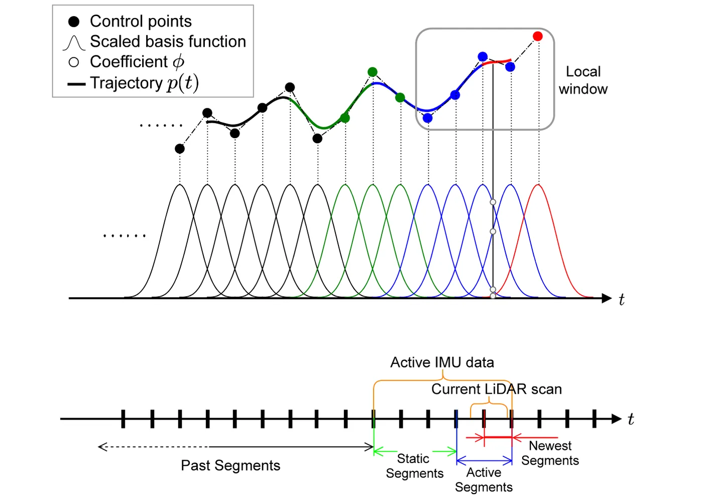
CLINS 以兩組累積式均勻三次 B 樣條分別表示位置與旋轉,將 LiDAR 慣性系統的軌跡建模為連續時間函數。每個新掃描到達時先以 IMU 積分初始化新增控制點,再在局部視窗內把 LOAM 邊緣與平面特徵以各點自身時間戳記的位姿投影到關鍵掃描子地圖,與原始加速度計、陀螺儀殘差一起做非剛性配準,同時估計控制點與 IMU 偏差,因此去畸變與位姿估計在同一最佳化中完成。迴圈閉合時採兩階段修正:先對關鍵掃描的離散位姿做位姿圖最佳化,再以修正後的位姿為錨點、以原軌跡的局部線速度與角速度維持局部形狀,重新擬合樣條控制點。
本頁內容
Continuous-time LIO that models the trajectory with split cumulative cubic B-splines, estimates new control points and IMU biases by sliding-window non-rigid registration of LOAM edge and planar features tightly coupled with raw IMU residuals, and handles loop closure by discrete key-scan pose-graph optimization followed by refitting the spline to the corrected poses while preserving local velocities.
技術屬性
欄位內容為文獻擷取紀錄的原文用語(英文),以原文為據;「未查證」表示本研究尚未讀到該資訊,不代表該方法不具備此能力。
| 感測輸入 | 3D spinning LiDAR (Velodyne VLP-16 in the YQ and KAIST Urban tests)、IMU (Xsens MTi-300) |
|---|---|
| 原文測試平台 | wheeled UGV (self-assembled small vehicle, YQ sequences)、vehicle (KAIST Urban, LiDAR tilted about 45 deg)、handheld (LIO-SAM datasets, qualitative only)、原文未報告 (LIOM room-scale sequences) |
| 狀態估計 | sliding-window batch nonlinear least squares (MAP) over the active B-spline control points and IMU biases, tightly coupling LiDAR feature residuals with raw accelerometer and gyroscope residuals; Levenberg-Marquardt in Ceres with automatic differentiation; static control points enter the problem but stay fixed (Sec. IV-B) |
| 資料關聯 | LOAM-style edge and planar features selected by local curvature; nearest-neighbour correspondences in a local submap of key-scans; point-to-line and point-to-plane residuals evaluated with the pose at each point's own timestamp (Sec. IV-B) |
| 時間表示 | continuous-time: split representation with cumulative uniform cubic B-splines for position in R3 and orientation in SO(3); knot spacing 0.05 s for the highly dynamic room-scale LIOM sequences and 0.1 s for the slower vehicle data (Sec. III, Fig. 2, V-A, V-B) |
| 去畸變 | implicit in the non-rigid registration: every point is mapped with the spline pose at its timestamp; key-scans added to the submap are undistorted to scan start with the non-active trajectory (Sec. IV-B) |
| 迴圈閉合 | yes; loop closures between key-scans trigger a two-stage correction (loop detection method not described in the paper) (Sec. IV-C) |
| 全域最佳化 | stage 1: discrete pose-graph optimization over key-scan poses; stage 2: refit spline control points to the corrected key-scan poses while constraining local linear and angular velocities computed from the pre-correction trajectory (Eq. 10, Sec. IV-C) |
| 地圖表示 | local submap of key-scans selected by spatio-temporal distance (feature points); global point map assembled from undistorted scans along the continuous trajectory |
| 先驗資訊 | pre-calibrated LiDAR-IMU extrinsic from the authors' LI-Calib toolbox (Sec. III) |
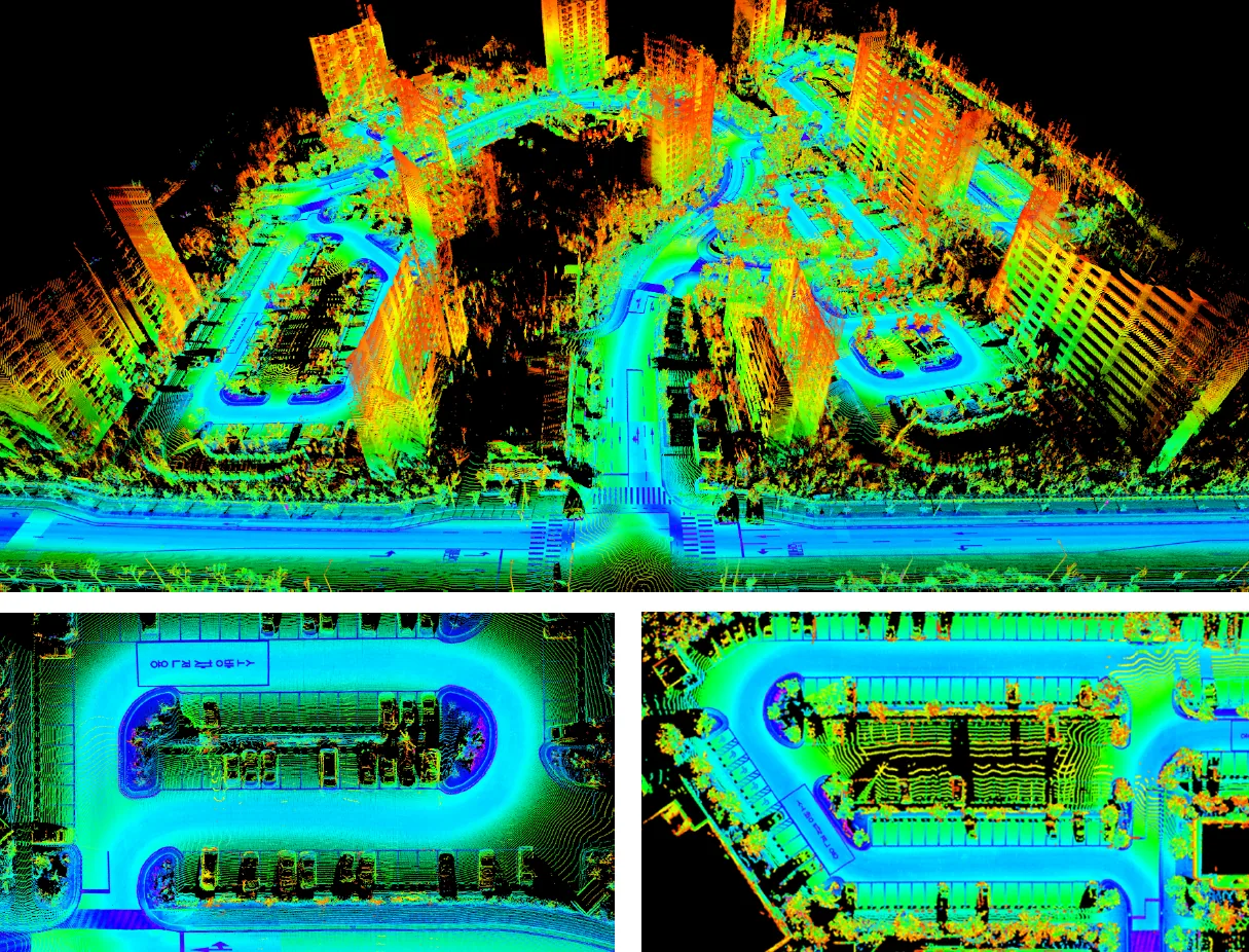
| 可輸出幾何 | continuous-time trajectory queryable at any timestamp (evaluated at 100 Hz) and an assembled 3D point cloud map; the trajectory was also used to assemble 2D SICK LMS-511 scans into a dense 3D reconstruction (Fig. 1, Sec. V-C) |
| 計算需求 | not real time as reported: non-rigid registration converges in four or five iterations and takes about 200 ms per scan with automatic differentiation; hardware not reported (Sec. V-D) |
使用設備
原文使用的感測器、運算硬體與載具(equipment)。型號保留原文寫法,連結到設備頁中同一型號的歸併名稱;角色依原文用途分為方法輸入、資料集感測器、執行運算平台、參考或真值量測(reference or ground truth)與比較對象設備。
| 類別 | 型號(原文寫法) | 角色 | 資料集 | 原文規格 | 出處 |
|---|---|---|---|---|---|
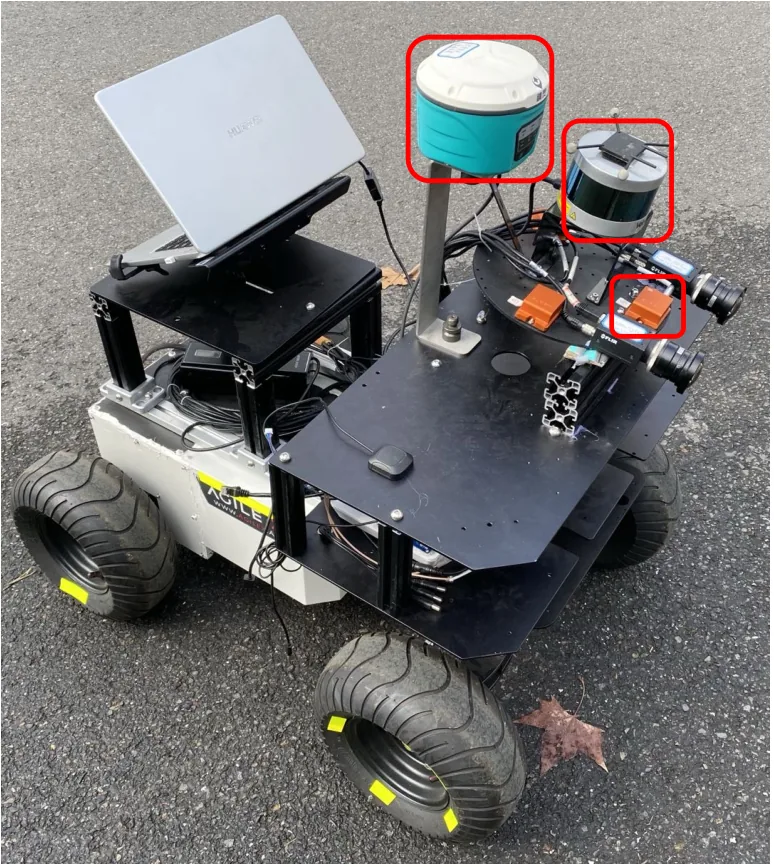
| LiDAR | Velodyne VLP-16 | 方法輸入 | YQ (authors' campus sequences) | 3D LiDAR on the self-assembled vehicle | (Lv et al., 2021, Sec. V-B; Fig. 5) |
| LiDAR | Velodyne VLP-16 | 資料集感測器 | KAIST Urban (Complex Urban dataset) | 3D LiDAR mounted on the vehicle at a tilt of about 45 degrees | (Lv et al., 2021, Sec. V-B; Fig. 1 caption) |
| LiDAR | SICK LMS-511 | 資料集感測器 | KAIST Urban (Complex Urban dataset) | 2D LiDAR; not used for estimation, only assembled with the CLINS trajectory for dense reconstruction | (Lv et al., 2021, Fig. 1; Sec. V-C) |
| 慣性量測單元(IMU) | Xsens-300 IMU (as written in Sec. V-B) | 方法輸入 | YQ (authors' campus sequences) | 原文未報告 | (Lv et al., 2021, Sec. V-B) |
| 慣性量測單元(IMU) | Xsens MTi-300 | 資料集感測器 | KAIST Urban (Complex Urban dataset) | 原文未報告 | (Lv et al., 2021, Fig. 1 caption) |
| GNSS 接收器 | JingLing-K50 RTK-GPS | 參考或真值量測 | YQ (authors' campus sequences) | RTK-GPS; shown as the 'GPS' reference trajectory in Fig. 6 | (Lv et al., 2021, Sec. V-B; Fig. 6) |
| 載具平台 | self-assembled small unmanned ground vehicle | 方法輸入 | YQ (authors' campus sequences) | sensors rigidly mounted; red-boxed sensors used for YQ | (Lv et al., 2021, Fig. 5) |
論文圖片
只收錄原文以開放授權(open license)釋出的圖片,並依授權條件標示出處、圖號、授權與修改方式。
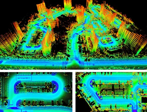
Fig. 1以 CLINS 連續時間軌跡組合 SICK LMS-511 二維 LiDAR 掃描,得到 KAIST Urban-07 的稠密三維重建
出處:Lv et al., 2021,Fig. 1。授權:CC BY 4.0。原始圖檔。修改:轉存為 WebP 格式。
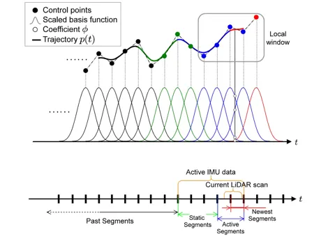
Fig. 2連續時間軌跡示意:活動區段、靜態控制點與新增控制點在三次 B 樣條上的關係
出處:Lv et al., 2021,Fig. 2。授權:CC BY 4.0。原始圖檔。修改:縮小至寬度不超過 1400 px,並轉存為 WebP 格式。
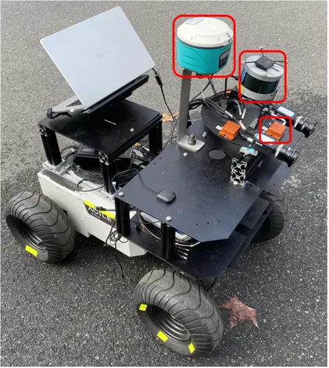
Fig. 5作者自組的無人地面車感測器平台,紅框為收集 YQ 序列所用感測器
出處:Lv et al., 2021,Fig. 5。授權:CC BY 4.0。原始圖檔。修改:轉存為 WebP 格式。
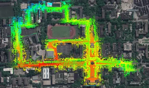
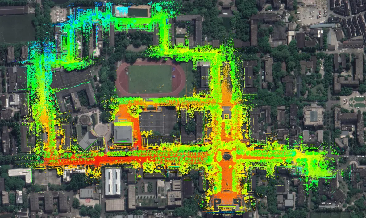
Fig. 6Fig. 6 下半部:CLINS 含迴圈修正在 YQ-01 建立的點雲地圖(約 700 m 乘 500 m),作者表示與 Google Earth 影像一致;連結僅為地圖子圖
出處:Lv et al., 2021,Fig. 6。授權:CC BY 4.0。原始圖檔。修改:轉存為 WebP 格式。
作者報告的優勢與限制
優勢
- Lowest translation RMSE of LOAM, LIO-SAM, LIOM and CLINS on all six LIOM fast, mid and slow sequences, with rotation RMSE similar to LIOM (Table II)
- With loop correction, lowest APE RMSE on Kaist-Urban-07 (0.562 m) and Kaist-Urban-08 (1.133 m) among the compared methods (Table IV)
- Derivatives of the estimated spline follow the raw IMU signal on fast1, where angular rate spans about -4.9 to 6.2 rad/s and acceleration reaches 5.8 m/s2 (Sec. V-A, Fig. 4)
- Poses can be queried at any time; CLINS was evaluated at 100 Hz versus about 5 Hz output for LIOM and 10 Hz for LIO-SAM (Sec. V-A)
- The globally corrected continuous trajectory can georeference a 2D LiDAR to build a dense 3D reconstruction (Sec. V-C, Fig. 1)
限制
- About 200 ms per non-rigid registration with automatic derivatives; authors name analytic Jacobians and efficient spline derivatives as needed for real time (Sec. V-D, VI)
- Without loop correction CLINS(odom) had higher APE RMSE than LIO-SAM(odom) on Kaist-Urban-07 (1.383 vs 1.288 m) and Kaist-Urban-08 (3.907 vs 3.524 m) (Table IV)
- With loop correction, LIO-SAM was slightly better on YQ-01 (2.220 vs 2.311 m) and LIOM was better on YQ-02 (0.881 vs 1.509 m) (Table IV)
- LOAM and LIOM values in Table II were copied from the LIOM paper rather than re-run (Sec. V-A)
- Handheld results are qualitative maps only; extrinsics must be pre-calibrated (Sec. V-B, III)
營建工程相關證據
論文未在營建工地或既有建物中以獨立幾何參考驗證;定量結果只有 LIOM 提供的房間尺度序列,以及校園與城市道路的車載序列(YQ 以 RTK-GPS 為參考)。其連續時間非剛性配準可在同一最佳化中處理手持劇烈運動造成的掃描畸變,概念上適用於工地手持掃描,但作者報告每次配準約 200 ms,原型實作不適合直接即時使用(推論)。GLIM (Koide et al., 2024)於 Newer College 比較表中將 CLINS 列為基準方法。
原文驗證環境:公開基準、受控實驗、獨立參考量測
報告的性能數據
以下是原文作者報告的性能數值(author-reported results),不是本研究重新量測的結果。每張圖只並列同一個比較組(comparison group,同一張表、同一組實驗設定)內的方法;不同比較組之間的數值不可直接比較,也不構成排名。
本方法共出現在 5 個比較組,合計 35 筆紀錄。以下列出本方法紀錄最多的 4 組,其餘 1 組列在最後,並連到性能比較頁。
Lv et al., 2021 · Table II 本方法 12 筆
表格設定(擷取紀錄原文):LIOM room-scale sequences with ground truth (fast/mid/slow motion); translation and rotation RMSE; LOAM and LIOM values copied from the LIOM paper; CLINS knot spacing 0.05 s and poses queried at 100 Hz (Lv et al., 2021, Table II)
Translation RMSE,LIOM dataset (Ye et al., ICRA 2019) · fast1
只並列這張表在相同設定下報告的方法;以「本方法:」開頭者為本頁方法。失敗、未執行與未報告以標記呈現,不是 0。
按 Tab 進入圖表後,用上下方向鍵逐一瀏覽各類別,Esc 關閉提示框;也可開啟表格檢視閱讀全部數值。
這些是 Lv et al., 2021 在此表設定下報告的數值(author-reported results),只能在同一個比較組內對照,不代表方法在其他資料或設定下的表現。
資料來源作者報告值(Lv et al., 2021, Table II)
| 方法(原文寫法) | 報告值 | 出處 |
|---|---|---|
| LOAM | 0.4469 m | (Lv et al., 2021, Table II) |
| LIO-SAM | 0.1058 m | (Lv et al., 2021, Table II) |
| LIOM | 0.0529 m | (Lv et al., 2021, Table II) |
| CLINS本方法原文提出 | 0.0436 m | (Lv et al., 2021, Table II) |
Lv et al., 2023 · Table III 本方法 9 筆
指標APE (RMSE, meter)
表格設定(擷取紀錄原文):NTU VIRAL dataset (MAV, indoor and outdoor); APE RMSE in metres; sensors L = LiDAR, I = IMU, C = camera, L2 = two LiDARs; rows marked (2) are results quoted from [51] (VIRAL SLAM preprint) and their loop-closure setting is not stated; CLINS, CLIO and CLIC variants run without loop closure (Lv et al., 2023, Table III)
APE (RMSE, meter),NTU VIRAL · eee_01 (237 m)
只並列這張表在相同設定下報告的方法;以「本方法:」開頭者為本頁方法。失敗、未執行與未報告以標記呈現,不是 0。
按 Tab 進入圖表後,用上下方向鍵逐一瀏覽各類別,Esc 關閉提示框;也可開啟表格檢視閱讀全部數值。
這些是 Lv et al., 2023 在此表設定下報告的數值(author-reported results),只能在同一個比較組內對照,不代表方法在其他資料或設定下的表現。
資料來源作者報告值(Lv et al., 2023, Table III)
| 方法(原文寫法) | 報告值 | 出處 |
|---|---|---|
| LIO-SAM(2) [L, I] | 0.075 m | (Lv et al., 2023, Table III; Sec. VI) |
| MILIOM (horz. LiDAR)(2) [L, I] | 0.104 m | (Lv et al., 2023, Table III; Sec. VI) |
| VIRAL (horz. LiDAR)(2) [L, I] | 0.064 m | (Lv et al., 2023, Table III; Sec. VI) |
| CLINS (w/o loop) [L, I]本方法 | 0.059 m | (Lv et al., 2023, Table III; Sec. VI) |
| CLIO (w/o loop) [L, I]原文提出 | 0.03 m | (Lv et al., 2023, Table III; Sec. VI) |
| CLIC (w/o loop) [L, I, C]原文提出 | 0.03 m | (Lv et al., 2023, Table III; Sec. VI) |
| MILIOM (2 LiDARs)(2) [L2, I] | 0.067 m | (Lv et al., 2023, Table III; Sec. VI) |
| VIRAL (2 LiDARs)(2) [L2, I, C] | 0.06 m | (Lv et al., 2023, Table III; Sec. VI) |
| CLIO2 (w/o loop) [L2, I]原文提出 | 0.04 m | (Lv et al., 2023, Table III; Sec. VI) |
| CLIC2 (w/o loop) [L2, I, C]原文提出 | 0.038 m | (Lv et al., 2023, Table III; Sec. VI) |
Lv et al., 2021 · Table IV 本方法 8 筆
指標RMSE of APE
表格設定(擷取紀錄原文):Large-scale vehicle sequences; APE RMSE (evo) against provided ground truth (RTK-GPS for YQ, dataset ground truth for KAIST); (odom) = without loop correction; knot spacing 0.1 s (Lv et al., 2021, Table IV)
RMSE of APE,YQ (authors' campus sequences) · YQ-01 (3.26 km)
只並列這張表在相同設定下報告的方法;以「本方法:」開頭者為本頁方法。失敗、未執行與未報告以標記呈現,不是 0。
按 Tab 進入圖表後,用上下方向鍵逐一瀏覽各類別,Esc 關閉提示框;也可開啟表格檢視閱讀全部數值。
這些是 Lv et al., 2021 在此表設定下報告的數值(author-reported results),只能在同一個比較組內對照,不代表方法在其他資料或設定下的表現。
資料來源作者報告值(Lv et al., 2021, Table IV)
| 方法(原文寫法) | 報告值 | 出處 |
|---|---|---|
| LIO-SAM (odom) | 8.857 m | (Lv et al., 2021, Table IV) |
| CLINS(odom)本方法原文提出 | 5.917 m | (Lv et al., 2021, Table IV) |
| LIOM | 3.931 m | (Lv et al., 2021, Table IV) |
| LIO-SAM | 2.22 m | (Lv et al., 2021, Table IV) |
| CLINS本方法原文提出 | 2.311 m | (Lv et al., 2021, Table IV) |
Lv et al., 2023 · Table VIII 本方法 5 筆
資料集與序列NTU VIRAL · eee_01 (397 s)
表格設定(擷取紀錄原文):Time consumption (seconds) of main modules over the whole eee_01 sequence (397 s) of NTU VIRAL on an Intel i7-7700K desktop with 32 GB RAM (Lv et al., 2023, Table VIII)
Update Local Map time over the sequence,NTU VIRAL · eee_01 (397 s)
只並列這張表在相同設定下報告的方法;以「本方法:」開頭者為本頁方法。失敗、未執行與未報告以標記呈現,不是 0。
按 Tab 進入圖表後,用上下方向鍵逐一瀏覽各類別,Esc 關閉提示框;也可開啟表格檢視閱讀全部數值。
這些是 Lv et al., 2023 在此表設定下報告的數值(author-reported results),只能在同一個比較組內對照,不代表方法在其他資料或設定下的表現。
資料來源作者報告值(Lv et al., 2023, Table VIII)
| 方法(原文寫法) | 報告值 | 出處 |
|---|---|---|
| CLINS本方法硬體:desktop PC, Intel i7-7700K, 32 GB RAM | 17.39 s | (Lv et al., 2023, Table VIII; Sec. VI-E) |
| CLIO原文提出硬體:desktop PC, Intel i7-7700K, 32 GB RAM | 11.56 s | (Lv et al., 2023, Table VIII; Sec. VI-E) |
| CLIC原文提出硬體:desktop PC, Intel i7-7700K, 32 GB RAM | 11.52 s | (Lv et al., 2023, Table VIII; Sec. VI-E) |
其他比較組
列出其餘 1 個比較組
來源
Lv et al., 2021
(2021)CLINS: Continuous-Time Trajectory Estimation for LiDAR-Inertial System2021 IEEE/RSJ International Conference on Intelligent Robots and Systems (IROS), pp. 6657-6663
DOI 10.1109/iros51168.2021.9636676arXiv 2109.04687程式碼
同儕審查已出版已讀全文近十年查證後修正
相關版本
- 預印本:arXiv 2109.04687 v1 (2021-09-10), only version https://arxiv.org/abs/2109.04687
- 程式碼釋出:APRIL-ZJU/clins https://github.com/APRIL-ZJU/clins
程式碼:https://github.com/APRIL-ZJU/clins(授權:GPL-3.0 (LICENSE file checked))。有公開程式碼不等於已被重現,也不代表目前版本與論文版本相同。