DARE-SLAM
DARE-SLAM 先以 ICP 解的特徵分析估計環境的幾何退化程度,並把模糊、不可觀測的區域排除在迴圈閉合搜尋之外,以免錯誤迴圈扭曲整張地圖。再以 LiDAR 點雲的 2D 與 3D 顯著特徵進行對漂移較不敏感的迴圈閉合。作者在礦坑與辦公室資料上評估。
本頁內容
Uses ICP eigen-analysis to gate loop-closure search away from degenerate regions and adds a drift-resilient loop closure based on salient LiDAR features.
技術屬性
欄位內容為文獻擷取紀錄的原文用語(英文),以原文為據;「未查證」表示本研究尚未讀到該資訊,不代表該方法不具備此能力。
| 感測輸入 | 3D LiDAR (Velodyne VLP-16 Puck Lite)、RGB-D camera (RealSense D435, object detection only) |
|---|---|
| 原文測試平台 | wheeled UGVs (Husky A200 series; single robot and two-robot teams in six US mines and an indoor office) |
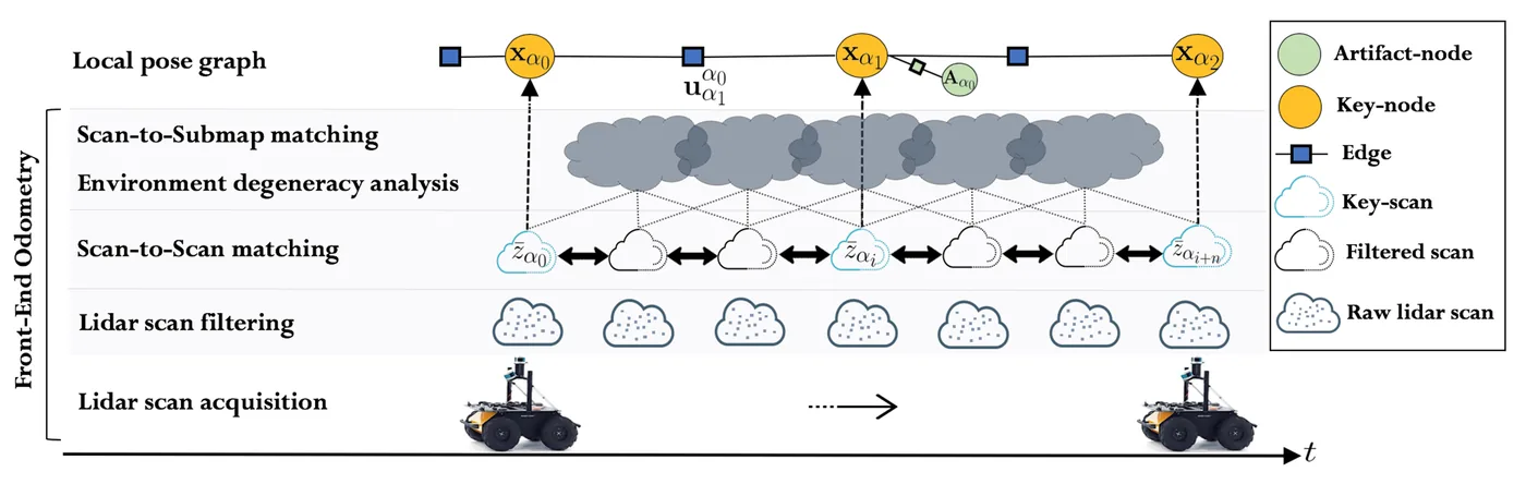
| 狀態估計 | LOAM-style edge and planar feature extraction (up to 90% point decimation), then two-stage GICP (scan-to-scan, then scan-to-submap) odometry; reduced pose graph with a key-node every 1 m translation or 30 deg rotation, back-end in GTSAM optimized by iterative nonlinear least squares (Levenberg-Marquardt named only as an example); local graphs per robot merged at a base station |
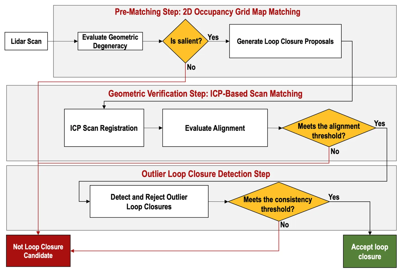
| 資料關聯 | GICP correspondences with approximate nearest-neighbour search against a local submap; degeneracy from the condition number of the ICP-derived approximate Hessian (log kappa threshold); loop-closure pre-matching with ORB features on binary occupancy-grid images, FLANN matching and RANSAC homography, scored by correspondence confidence times transformation confidence; ICP geometric verification seeded with the homography yaw |
| 時間表示 | 原文未報告 |
| 去畸變 | 原文未報告 |
| 迴圈閉合 | degeneracy-aware candidate gating plus pose-invariant multi-stage loop closing (SGLC): global pre-matching of 250 x 250-cell (5 m x 5 m) occupancy-grid images over the whole trajectory (maps with 20 or fewer inliers dropped), ICP geometric verification, and PCM pairwise-consistency outlier rejection; same pipeline for inter-robot loops |
| 全域最佳化 | pose graph optimization with a GTSAM back-end (iterative nonlinear optimization, Levenberg-Marquardt named only as an example) after PCM outlier rejection; single robot and centralized multi-robot merging at a base station assuming known initial robot poses |
| 地圖表示 | reduced pose graph whose key-nodes carry key-scans; global 3D point-cloud map formed by projecting key-scans into the world frame; per-key-scan 2D occupancy grids used only for place recognition |
| 先驗資訊 | known initial robot poses in a common world frame for multi-robot merging; proxy ground truth obtained by enforcing the known ground-truth locations of objects and fiducial markers (provided by DARPA) in each robot's pose graph (evaluation only) |
| 可輸出幾何 | 3D point-cloud maps of mines (single-robot and merged multi-robot) and optimized robot trajectories |
| 計算需求 | Onboard Intel NUC 7i7DNBE (4 x 1.9 GHz, 32 GB RAM) per robot; base station Intel Hades Canyon NUC8i7HVKVA (4 x 1.9 GHz, 32 GB RAM), for which real time was not strictly required; pre-matching can run on a separate thread; execution times given only as box plots (Fig. 18) |
使用設備
原文使用的感測器、運算硬體與載具(equipment)。型號保留原文寫法,連結到設備頁中同一型號的歸併名稱;角色依原文用途分為方法輸入、資料集感測器、執行運算平台、參考或真值量測(reference or ground truth)與比較對象設備。
| 類別 | 型號(原文寫法) | 角色 | 資料集 | 原文規格 | 出處 |
|---|---|---|---|---|---|
| LiDAR | Velodyne VLP-16 Puck Lite歸入:Velodyne VLP-16 | 方法輸入 | 未標示 | 原文未報告 (low vertical resolution noted as a cause of poor scan-to-scan estimates in narrow tunnels) | (Ebadi et al., 2021, Sec. 4; Sec. 3.1) |
| RGB-D 相機 | Intel RealSense D435 | 方法輸入 | 未標示 | RGB-D camera used for YOLO-based object detection and localization, not for SLAM | (Ebadi et al., 2021, Sec. 4) |
| 輪式或腿式里程計 | wheel-inertial odometry (sensor models not reported) | 參考或真值量測 | 未標示 | reference for lidar slip in a carpeted office corridor at low speed; wheel slippage stated to be negligible | (Ebadi et al., 2021, Sec. 3.2, Fig. 6) |
| 載具平台 | Husky A200 series | 方法輸入 | 未標示 | wheeled ground robot; up to two robots in multi-robot trials | (Ebadi et al., 2021, Sec. 4, Fig. 16) |
| 運算硬體 | Intel NUC 7i7DNBE | 執行運算平台 | 未標示 | 4 x 1.9 GHz, 32 GB RAM; onboard SLAM on each robot | (Ebadi et al., 2021, Sec. 4) |
| 運算硬體 | Intel Hades Canyon NUC8i7HVKVA | 執行運算平台 | 未標示 | 4 x 1.9 GHz, 32 GB RAM; base station merging local pose graphs | (Ebadi et al., 2021, Sec. 4) |
| 其他 | fiducial markers and objects with known ground-truth locations (provided by DARPA) | 參考或真值量測 | 未標示 | known locations enforced in each robot's pose graph to build proxy ground-truth trajectories; object positions also used to score object localization error | (Ebadi et al., 2021, Sec. 4, Sec. 4.3) |
論文圖片
只收錄原文以開放授權(open license)釋出的圖片,並依授權條件標示出處、圖號、授權與修改方式。
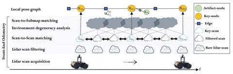
Fig. 3LiDAR 前端流程(點雲過濾、scan-to-scan 與 scan-to-submap 配準)與局部位姿圖
出處:Ebadi et al., 2021,Fig. 3。授權:CC BY 4.0 (arXiv v1 abs page); note: the arXiv PDF title-page footnote also prints '©2020 All rights reserved'。原始圖檔。修改:縮小至寬度不超過 1400 px,並轉存為 WebP 格式。
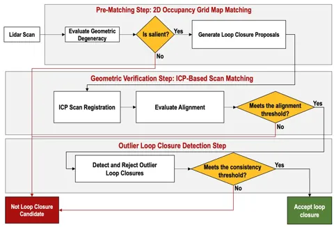
Fig. 10顯著性迴圈閉合流程:佔據格地圖預匹配、幾何驗證與離群值剔除
出處:Ebadi et al., 2021,Fig. 10。授權:CC BY 4.0 (arXiv v1 abs page); note: the arXiv PDF title-page footnote also prints '©2020 All rights reserved'。原始圖檔。修改:縮小至寬度不超過 1400 px,並轉存為 WebP 格式。
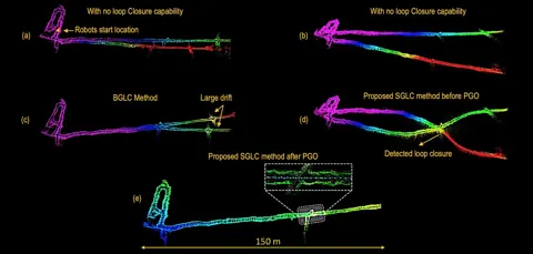
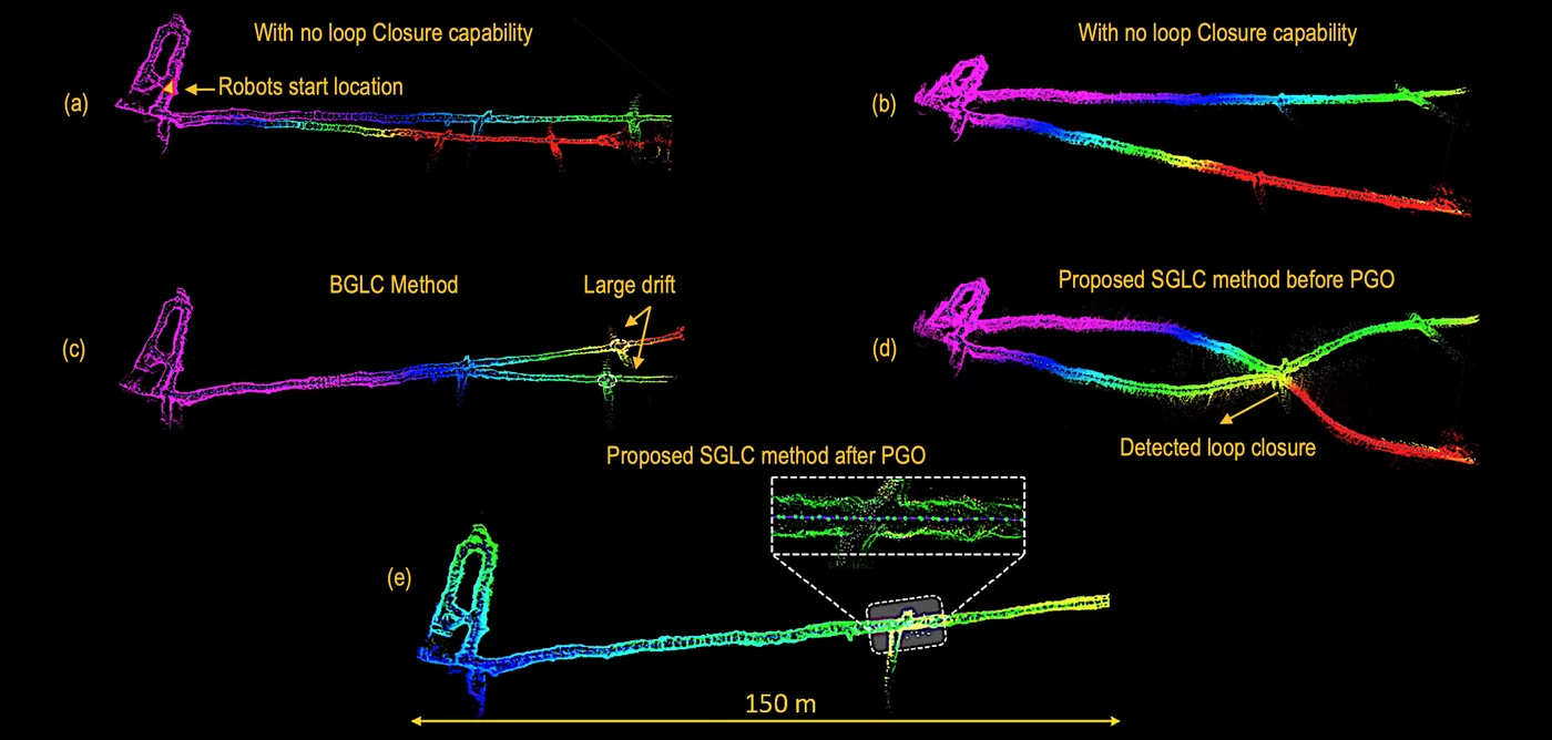
Fig. 21Eagle 礦坑雙機器人地圖:無迴圈閉合、BGLC 與本法在位姿圖最佳化前後的對照
出處:Ebadi et al., 2021,Fig. 21。授權:CC BY 4.0 (arXiv v1 abs page); note: the arXiv PDF title-page footnote also prints '©2020 All rights reserved'。原始圖檔。修改:縮小至寬度不超過 1400 px,並轉存為 WebP 格式。
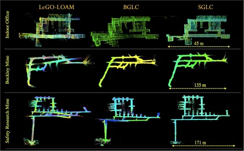
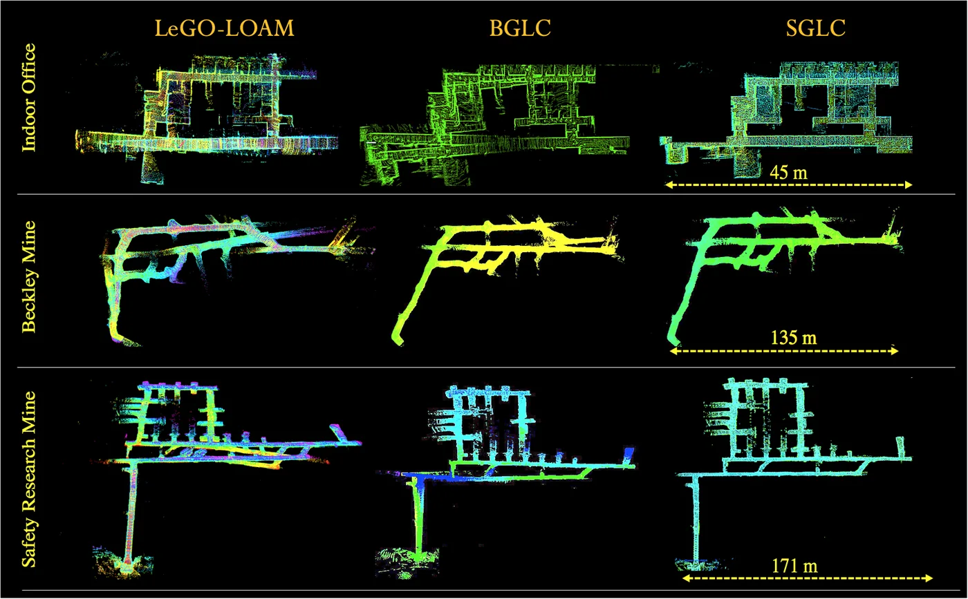
Fig. 23辦公室、Beckley 煤礦與 Safety Research 礦坑以 LeGO-LOAM、BGLC 與本法建立的地圖比較
出處:Ebadi et al., 2021,Fig. 23。授權:CC BY 4.0 (arXiv v1 abs page); note: the arXiv PDF title-page footnote also prints '©2020 All rights reserved'。原始圖檔。修改:縮小至寬度不超過 1400 px,並轉存為 WebP 格式。
作者報告的優勢與限制
優勢
- SGLC loop closing gave lower APE than LeGO-LOAM and BGLC in four subterranean datasets (10 runs each; APE from known landmark locations used as proxy ground truth) (Sec. 4, Fig. 25)
- Geometric degeneracy detector reached AUC 0.887 on 254 manually labelled scans (61 degenerate) (Sec. 3.2, Fig. 7)
- Occupancy-grid pre-matching reached an average AUC of 0.756 across five environments (Sec. 4.1, Fig. 17)
- Scan-to-submap refinement cut average drift per 300 m from 6% to below 1% (Safety Research mine) and from 27% to 2% (Experimental mine) (Sec. 3.1)
限制
- All compared methods, including the proposed one, showed larger drift in mines with long, flat, featureless corridors (Sec. 4, discussion of Fig. 25)
- Pre-matching produces more false positives in self-similar indoor offices (identical cubicles) than in mines, so geometric verification and outlier rejection are still required (Sec. 4.1)
- Even with scan-to-submap refinement the front-end drift in the Experimental mine remains substantially large, so loop closure is still needed (Sec. 3.1)
- Ground truth is a proxy built from known object and fiducial locations, not a full reference trajectory (Sec. 4)
營建工程相關證據
未在工地測試;地下礦坑的長直無特徵廊道結論可類比隧道施工(推論)。
原文驗證環境:地下或隧道、已完工建築
報告的性能數據
以下是原文作者報告的性能數值(author-reported results),不是本研究重新量測的結果。每張圖只並列同一個比較組(comparison group,同一張表、同一組實驗設定)內的方法;不同比較組之間的數值不可直接比較,也不構成排名。
本方法共出現在 3 個比較組,合計 4 筆紀錄。
Ebadi et al., 2021 · Text Sec. 3.1 本方法 2 筆
指標average translational drift per 300 m (relative position error)
表格設定(擷取紀錄原文):Front-end odometry drift from EVO relative pose error per 300 m travelled in autonomous traverses; values stated in text (Fig. 4 box plots); percentages are relative position error (Ebadi et al., 2021, Text Sec. 3.1)
average translational drift per 300 m (relative position error),authors' DARPA SubT Tunnel Circuit recordings · Bruceton Safety Research mine (1400 m)
只並列這張表在相同設定下報告的方法;以「本方法:」開頭者為本頁方法。失敗、未執行與未報告以標記呈現,不是 0。
- 僅報告範圍
按 Tab 進入圖表後,用上下方向鍵逐一瀏覽各類別,Esc 關閉提示框;也可開啟表格檢視閱讀全部數值。
這些是 Ebadi et al., 2021 在此表設定下報告的數值(author-reported results),只能在同一個比較組內對照,不代表方法在其他資料或設定下的表現。
資料來源作者報告值(Ebadi et al., 2021, Text Sec. 3.1)
| 方法(原文寫法) | 報告值 | 出處 |
|---|---|---|
| scan-to-scan GICP registration only | 6%僅報告範圍註記(擷取紀錄):stated as more than 18 m average drift per 300 m (6%) | (Ebadi et al., 2021, Sec. 3.1) |
| scan-to-scan plus scan-to-submap GICP (two-stage front-end from LAMP used in DARE-SLAM)本方法原文提出 | 1%僅報告範圍註記(擷取紀錄):stated as less than 1% of distance per 300 m | (Ebadi et al., 2021, Sec. 3.1) |
Ebadi et al., 2021 · Text Sec. 3.2 本方法 1 筆
指標area under ROC curve (AUC) of the degeneracy detector
資料集與序列authors' labelled scans · 254 lidar scans
表格設定(擷取紀錄原文):ROC analysis of the geometric degeneracy detector on 254 manually labelled lidar scans, 61 of them degenerate (Ebadi et al., 2021, Text Sec. 3.2)
area under ROC curve (AUC) of the degeneracy detector,authors' labelled scans · 254 lidar scans
這張表在此指標與資料序列只列出本方法一筆,沒有可並列的其他方法,因此不畫圖,數值與出處見下表。這是 Ebadi et al., 2021 在此表設定下報告的數值(author-reported results),不代表方法在其他資料或設定下的表現。
| 方法(原文寫法) | 報告值 | 出處 |
|---|---|---|
| degeneracy detector (log condition number of approximate Hessian)本方法原文提出 | 0.887 | (Ebadi et al., 2021, Sec. 3.2, Fig. 7) |
Ebadi et al., 2021 · Text Sec. 4.1 本方法 1 筆
指標average AUC for identifying loop closures
資料集與序列authors' recordings · five environments
表格設定(擷取紀錄原文):ROC analysis of occupancy-grid pre-matching; 100 salient grid maps per environment, 20 of which are true loop closures (Ebadi et al., 2021, Text Sec. 4.1)
average AUC for identifying loop closures,authors' recordings · five environments
這張表在此指標與資料序列只列出本方法一筆,沒有可並列的其他方法,因此不畫圖,數值與出處見下表。這是 Ebadi et al., 2021 在此表設定下報告的數值(author-reported results),不代表方法在其他資料或設定下的表現。
| 方法(原文寫法) | 報告值 | 出處 |
|---|---|---|
| SGLC pre-matching (similarity confidence)本方法原文提出 | 0.756 | (Ebadi et al., 2021, Sec. 4.1, Fig. 17) |
來源
Ebadi et al., 2021
(2021)DARE-SLAM: Degeneracy-Aware and Resilient Loop Closing in Perceptually-Degraded EnvironmentsJournal of Intelligent & Robotic Systems, 102(1), article 2
DOI 10.1007/s10846-021-01362-warXiv 2102.05117
同儕審查已出版已讀全文近十年查證後修正
相關版本
- 預印本:DARE-SLAM: Degeneracy-Aware and Resilient Loop Closing in Perceptually-Degraded Environments https://arxiv.org/abs/2102.05117