NIFCyl tunnel deformation from SLAM LiDAR
作者提出 NIFCyl:以 8 層 MLP 非監督學習參考點雲的有號距離場,取其梯度作為尺度不變且方向一致的法向,再沿法向以圓柱鄰域平均兩期點雲的投影位置,求得全場變形,不需標註資料或局部 PCA 擬合。資料以手持 Hovermap ST 在西澳 Kalgoorlie 地下硬岩礦取得,兩期點雲以四個噴漆控制點做 SVD 粗配準,再以 ICP 細配準。合成變形情境中 NIFCyl 的 R² 為 0.963、RMSE 0.009 m、總計算 187 秒,三種尺度設定的 M3C2 中最佳者為 0.955、0.010 m、995 秒;現地放置紙箱的試驗中,平面區兩者 MAE 同為 0.022 m,曲面區為 0.032 m 對 0.034 m。實際擴挖案例只以單一點的人工量測(2.513 m)與模型結果(2.505 m)比對。
本頁內容
NIFCyl learns an SDF of the reference tunnel cloud with an MLP, uses its gradient as normals and averages cylinder projections along them; on handheld Hovermap ST scans from a Kalgoorlie mine it beats multi-scale M3C2 on synthetic deformation (R2 0.963, RMSE 0.009 m, 187 s vs 995 s) and on a curved field target (MAE 0.032 vs 0.034 m), and ties on a planar one (0.022 m).
技術屬性
欄位內容為文獻擷取紀錄的原文用語(英文),以原文為據;「未查證」表示本研究尚未讀到該資訊,不代表該方法不具備此能力。
| 感測輸入 | handheld Hovermap ST LiDAR SLAM scanner (Table 1: FoV 360 x 290 deg, range 0.40 to 100 m, LiDAR accuracy +/-30 mm, mapping accuracy +/-15 mm in typical underground and indoor environments, SLAM drift +/-0.03%, up to 300,000 pts/s single return and 600,000 pts/s dual return) |
|---|---|
| 原文測試平台 | handheld |
| 狀態估計 | 不適用 (deformation analysis of SLAM point clouds) |
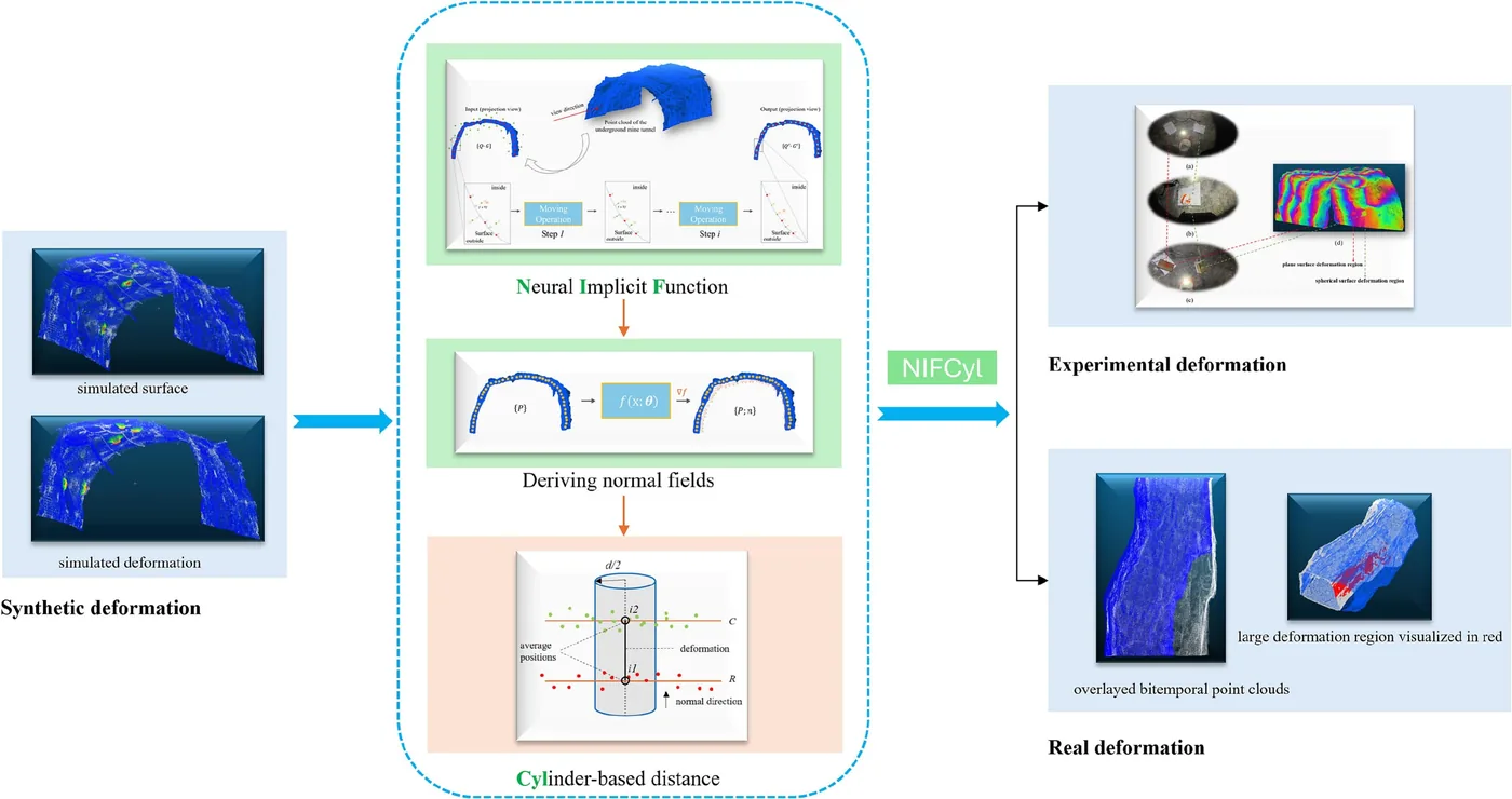
| 資料關聯 | SDF learned by an 8-layer MLP gives normals via its gradient; deformation measured by averaging reference and compared points inside a cylinder along each normal; epochs aligned by GCP-based SVD then ICP |
| 時間表示 | 不適用 |
| 去畸變 | 不適用 |
| 迴圈閉合 | 不適用 |
| 全域最佳化 | 不適用 |
| 地圖表示 | neural implicit function of tunnel surface; scale-invariant normal field (per abstract) |
| 先驗資訊 | no labels (unsupervised); four painted ground control points per scan location used for coarse registration of epochs before ICP |
| 可輸出幾何 | full-field deformation map |
| 計算需求 | Linux desktop with Intel Core i9 14900K CPU and NVIDIA RTX4080 Super GPU; NIFCyl 187 s total (47 s deformation step) vs M3C2 995 to 6276 s on the synthetic set; 20,000 iterations, Adam |
使用設備
原文使用的感測器、運算硬體與載具(equipment)。型號保留原文寫法,連結到設備頁中同一型號的歸併名稱;角色依原文用途分為方法輸入、資料集感測器、執行運算平台、參考或真值量測(reference or ground truth)與比較對象設備。
| 類別 | 型號(原文寫法) | 角色 | 資料集 | 原文規格 | 出處 |
|---|---|---|---|---|---|
| 行動掃描設備 | Hovermap ST (Table 1: 'Hovermap ST AUTONOMY') | 方法輸入 | 未標示 | SLAM drift +/-0.03%; FoV 360 x 290 deg; range 0.40 to 100 m; LiDAR accuracy +/-30 mm; mapping accuracy +/-15 mm in typical underground and indoor environments; intensity, range, time, return number and ring attributes; up to 300,000 pts/s single return, 600,000 pts/s dual return; handheld, 60 m closed loop in about 5 min | (Han et al., 2026, Sec. 2.2, Table 1) |
| 運算硬體 | Intel Core i9 14900K | 執行運算平台 | 未標示 | desktop CPU, Linux | (Han et al., 2026, Sec. 4.1) |
| 運算硬體 | NVIDIA RTX4080 Super | 執行運算平台 | 未標示 | desktop GPU | (Han et al., 2026, Sec. 4.1) |
| 其他 | painted ground control points (circular marker with crosshair on white spray coating, Roman numeral ID) | 方法輸入 | 未標示 | four stable sidewall regions per scan location | (Han et al., 2026, Sec. 2.1, Fig. 1) |
| 其他 | ruler | 參考或真值量測 | 未標示 | measured box height 9.5 cm as planar ground truth | (Han et al., 2026, Sec. 4.4) |
論文圖片
只收錄原文以開放授權(open license)釋出的圖片,並依授權條件標示出處、圖號、授權與修改方式。
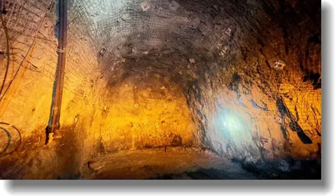
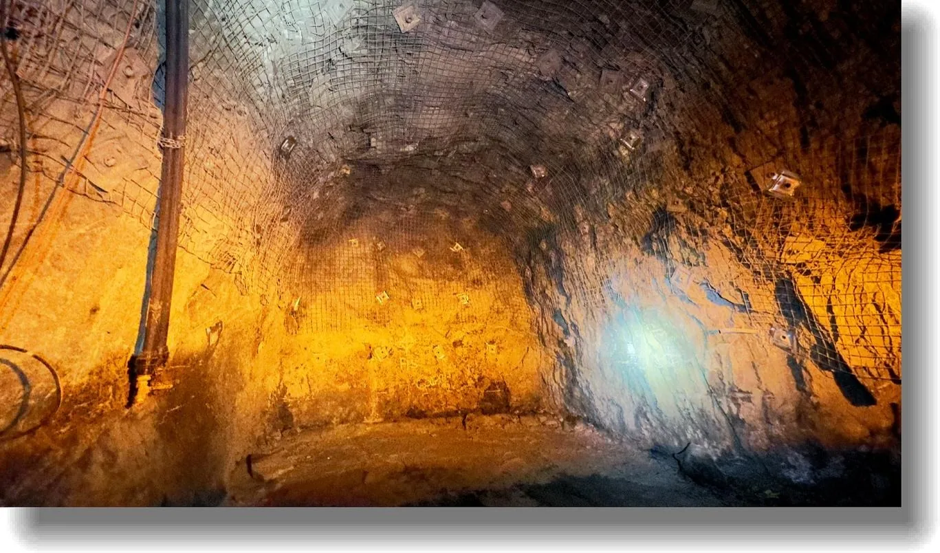
Fig. 2地下硬岩礦巷道現場環境:低光、多粉塵、鋼網與岩栓支撐的粗糙岩面
出處:Han et al., 2026,Fig. 2。授權:CC BY 4.0。原始圖檔。修改:轉存為 WebP 格式。
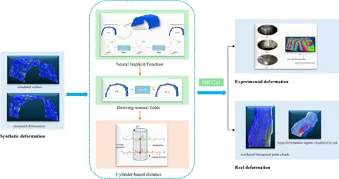
Fig. 3NIFCyl 方法流程:合成變形資料、神經隱式法向計算、圓柱式變形量測
出處:Han et al., 2026,Fig. 3。授權:CC BY 4.0。原始圖檔。修改:縮小至寬度不超過 1400 px,並轉存為 WebP 格式。
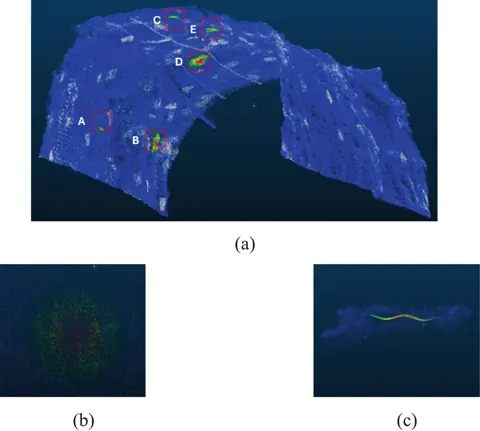
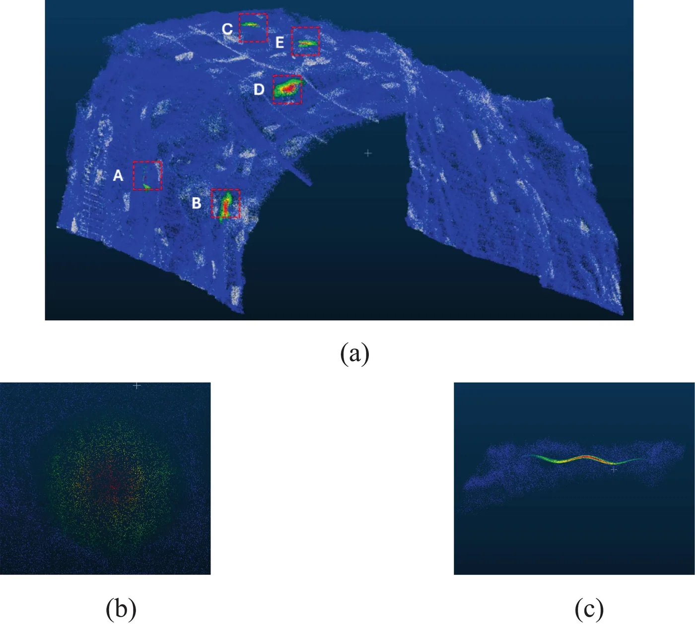
Fig. 4巷道點雲(約 185 萬點)中以數學曲面取代的五個測試區 A 至 E,及單一區域俯視與側視
出處:Han et al., 2026,Fig. 4。授權:CC BY 4.0。原始圖檔。修改:縮小至寬度不超過 1400 px,並轉存為 WebP 格式。
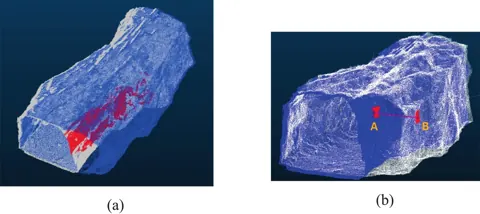
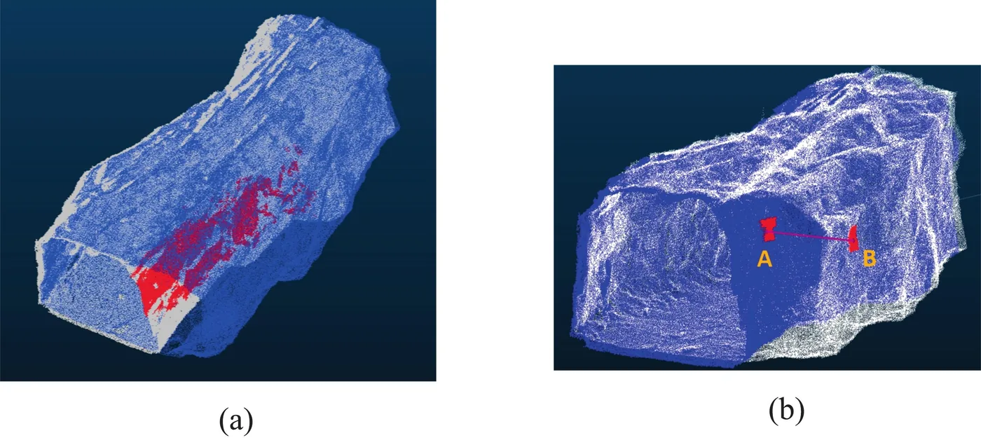
Fig. 15實際擴挖案例的 NIFCyl 結果:大於 2 m 擴挖的點以紅色標示,並以兩個平坦區中心距離作人工比對
出處:Han et al., 2026,Fig. 15。授權:CC BY 4.0。原始圖檔。修改:縮小至寬度不超過 1400 px,並轉存為 WebP 格式。
作者報告的優勢與限制
優勢
- synthetic: R2 0.963 and RMSE 0.009 m vs best M3C2 (0.05 to 0.55 m scale) 0.955 and 0.010 m; 187 s vs 995 s (Table 4)
- curved field target MAE 0.032 m vs 0.034 m for M3C2 (Sec. 4.4)
- robust to 20% point removal (R2 0.956, RMSE 0.010 m) and to noise at 10% of deformation (R2 0.938, RMSE 0.012 m) (Table 5)
- noise floor in stable regions: sigma 0.0035 m short-term field, 0.0151 m over two months (Table 6)
- code and datasets shared on GitHub (Data availability)
限制
- evaluation relies on a limited set of multi-temporal scans from one mine (Sec. 4.8)
- ICP-based registration contributes systemic noise; real-scenario detection threshold set at 3.0 cm (Sec. 4.7, 4.8)
- tunnel treated as a single entity without semantic segmentation (Sec. 4.8)
- for tunnels longer than about 60 m the authors recommend splitting the cloud into sections (sliding window) because a single global volume causes memory and time bottlenecks (Sec. 4.3)
- planar field target shows no gain over M3C2 (both MAE 0.022 m) (Sec. 4.4)
- real-deformation case checked only qualitatively plus one manual point-to-point measurement (Sec. 4.5)
- at noise 20% of deformation R2 drops to 0.858 and RMSE rises to 0.018 m (Table 5)
營建工程相關證據
西澳 Kalgoorlie 地下硬岩礦的鑽炸巷道(岩面粗糙,鋼網與岩栓支撐),含相隔兩個月、因撬落浮石(scaling)造成約 2 m 以上擴挖的實例;與隧道開挖變形監測高度相關,但屬礦業巷道而非土木隧道施工(Sec. 2.2, 4.5)。
原文驗證環境:模擬、受控實驗、地下或隧道
報告的性能數據
以下是原文作者報告的性能數值(author-reported results),不是本研究重新量測的結果。每張圖只並列同一個比較組(comparison group,同一張表、同一組實驗設定)內的方法;不同比較組之間的數值不可直接比較,也不構成排名。
本方法共出現在 5 個比較組,合計 23 筆紀錄。以下列出本方法紀錄最多的 4 組,其餘 1 組列在最後,並連到性能比較頁。
Han et al., 2026 · Table 6 本方法 9 筆
表格設定(擷取紀錄原文):Deformation residuals of NIFCyl in undeformed regions (Gaussian fit); synthetic N=113,059, experimental N=121,151, real N=104,031 (Han et al., 2026, Table 6)
u (m), Gaussian fitted mean residual,own field test, Kalgoorlie underground mine · experimental deformation scans (30 min apart), stable region
這張表在此指標與資料序列只列出本方法一筆,沒有可並列的其他方法,因此不畫圖,數值與出處見下表。這是 Han et al., 2026 在此表設定下報告的數值(author-reported results),不代表方法在其他資料或設定下的表現。
| 方法(原文寫法) | 報告值 | 出處 |
|---|---|---|
| NIFCyl本方法原文提出 | 0.0007 m | (Han et al., 2026, Table 6) |
Han et al., 2026 · Table 5 本方法 8 筆
表格設定(擷取紀錄原文):Robustness of NIFCyl on the synthetic dataset under random point removal and added zero-mean Gaussian noise (sigma as % of deformation) (Han et al., 2026, Table 5)
R2,synthetic deformation benchmark · point density -10%
這張表在此指標與資料序列只列出本方法一筆,沒有可並列的其他方法,因此不畫圖,數值與出處見下表。這是 Han et al., 2026 在此表設定下報告的數值(author-reported results),不代表方法在其他資料或設定下的表現。
| 方法(原文寫法) | 報告值 | 出處 |
|---|---|---|
| NIFCyl本方法原文提出 | 0.959 | (Han et al., 2026, Table 5) |
Han et al., 2026 · Table 4 本方法 3 筆
資料集與序列synthetic deformation benchmark from Hovermap ST scan · regions A to E
表格設定(擷取紀錄原文):Synthetic deformation on 5 regions (88,842 points) of a real mine tunnel cloud; M3C2 at three normal-scale ranges with empty values excluded (Han et al., 2026, Table 4)
R2 (against the 1:1 line),synthetic deformation benchmark from Hovermap ST scan · regions A to E
只並列這張表在相同設定下報告的方法;以「本方法:」開頭者為本頁方法。失敗、未執行與未報告以標記呈現,不是 0。
按 Tab 進入圖表後,用上下方向鍵逐一瀏覽各類別,Esc 關閉提示框;也可開啟表格檢視閱讀全部數值。
這些是 Han et al., 2026 在此表設定下報告的數值(author-reported results),只能在同一個比較組內對照,不代表方法在其他資料或設定下的表現。
資料來源作者報告值(Han et al., 2026, Table 4)
| 方法(原文寫法) | 報告值 | 出處 |
|---|---|---|
| NIFCyl本方法原文提出 | 0.963 | (Han et al., 2026, Table 4) |
| M3C2 small scale (0.05 to 0.55 m) | 0.955 | (Han et al., 2026, Table 4) |
| M3C2 medium scale (0.55 to 1.05 m) | 0.937 | (Han et al., 2026, Table 4) |
| M3C2 large scale (1.05 to 1.55 m) | 0.931 | (Han et al., 2026, Table 4) |
Han et al., 2026 · Text Sec.4.4 本方法 2 筆
指標Mean Absolute Error (m)
表格設定(擷取紀錄原文):Field test with two scans within half an hour; paper box (9.5 cm) on flat cardboard and box over half basketball on cardboard; Sec. 4.4 does not state how the two scans were aligned (the general Sec. 2.3 pipeline is GCP-based SVD then ICP) (Han et al., 2026, Text Sec.4.4)
Mean Absolute Error (m),own field test, Kalgoorlie underground mine · plane surface deformation region
只並列這張表在相同設定下報告的方法;以「本方法:」開頭者為本頁方法。失敗、未執行與未報告以標記呈現,不是 0。
按 Tab 進入圖表後,用上下方向鍵逐一瀏覽各類別,Esc 關閉提示框;也可開啟表格檢視閱讀全部數值。
這些是 Han et al., 2026 在此表設定下報告的數值(author-reported results),只能在同一個比較組內對照,不代表方法在其他資料或設定下的表現。
資料來源作者報告值(Han et al., 2026, Text Sec.4.4)
| 方法(原文寫法) | 報告值 | 出處 |
|---|---|---|
| NIFCyl本方法原文提出 | 0.022 m | (Han et al., 2026, Sec. 4.4) |
| M3C2 | 0.022 m | (Han et al., 2026, Sec. 4.4) |
其他比較組
列出其餘 1 個比較組
來源
Han et al., 2026
(2026)Full-field deformation quantification of underground tunnels using SLAM LiDAR point cloud based on unsupervised neural implicit learningTunnelling and Underground Space Technology, 175, 107777
DOI 10.1016/j.tust.2026.107777
同儕審查已出版已讀全文近十年