LIO-BIM
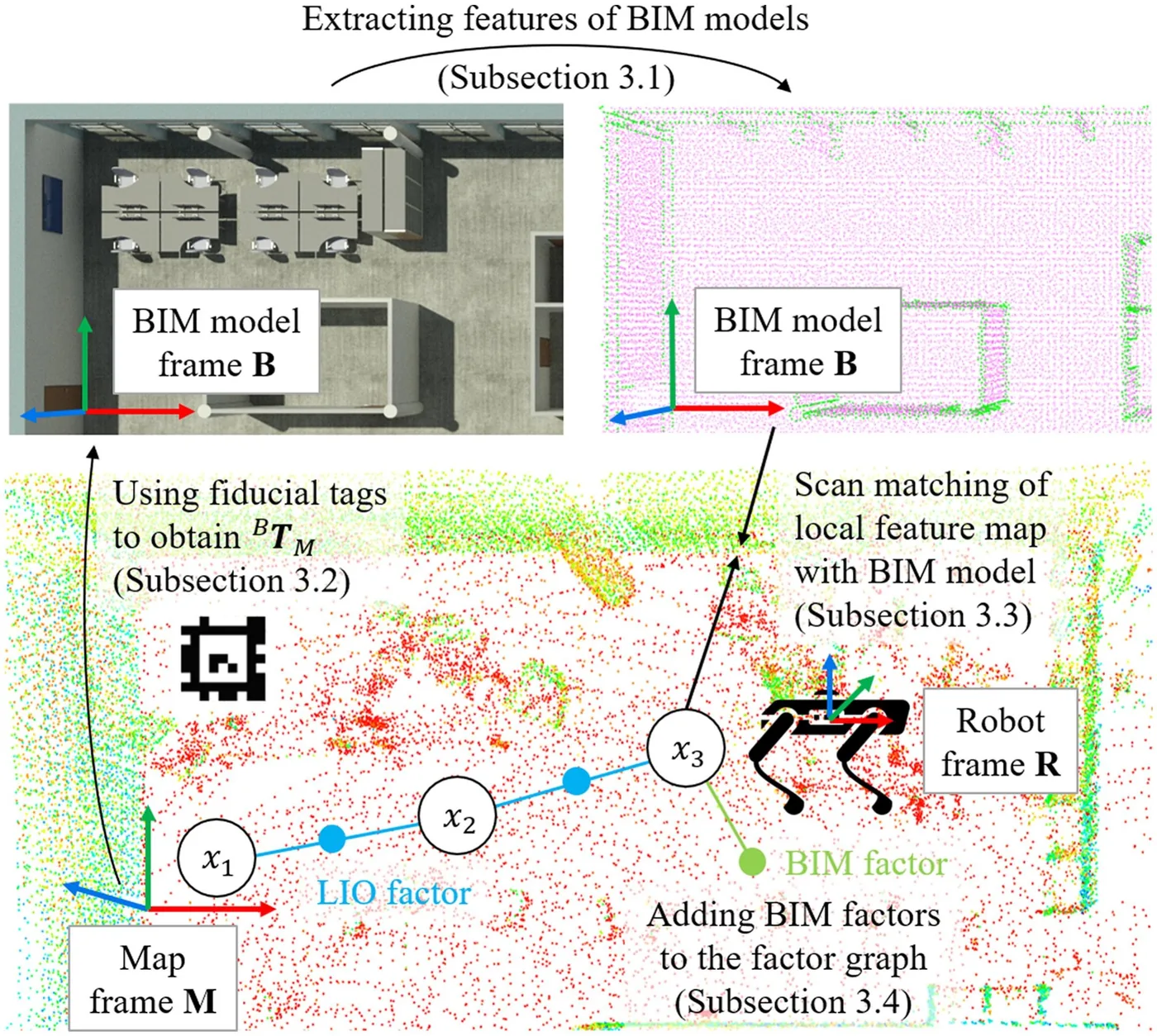
作者指出僅依 BIM 導出地圖定位需要高發展程度(LOD)模型,且非結構物件常與模型不符。LIO-BIM 以光達慣性里程計持續建立現況地圖,並將機器人周邊的局部地圖與 BIM 做掃描匹配,以同時取得相對 BIM 的定位與現況建圖。系統實作於四足機器人並在辦公室環境與 ConSLAM 工地資料集驗證,程式碼以開源釋出。
本頁內容
Couples lidar-inertial odometry with local-map-to-BIM matching to localize and map relative to limited-LOD BIM models despite scan-BIM deviations, validated in an office and on the ConSLAM construction dataset.
技術屬性
欄位內容為文獻擷取紀錄的原文用語(英文),以原文為據;「未查證」表示本研究尚未讀到該資訊,不代表該方法不具備此能力。
| 感測輸入 | 3D LiDAR (Velodyne VLP-16)、9-DoF IMU (LORD MicroStrain 3DM-GX5-25; Xsens MTi-610 in ConSLAM)、camera for AprilTag detection (Intel RealSense D435i; Alvium U-319c 3.2 MP in ConSLAM)、reference: Faro Focus S 70 TLS (office); Leica RTC 360 TLS scans of ConSLAM |
|---|---|
| 原文測試平台 | legged (Unitree A1-based 'IDOG')、handheld (ConSLAM dataset) |
| 狀態估計 | LIO-SAM-based factor graph; BIM factors added when local-map-to-BIM scan matching converges with inlier RMSE below and fitness above thresholds, with noise variance set to the inlier RMSE (Sec. 3.4) |
| 資料關聯 | feature-based ICP with edge (point-to-line) and planar (point-to-plane) correspondences solved by Levenberg-Marquardt, used both for LIO against preceding scans and for matching a 5 m local keyframe feature map to edge and planar feature clouds sampled from the IFC meshes (500 points/m2, curvature thresholds 0.6 and 0.1) |
| 時間表示 | 原文未報告 |
| 去畸變 | the latest lidar scan is deskewed in the LIO-SAM-derived front end before feature extraction (Sec. 3.3) |
| 迴圈閉合 | no loop closure module is described; long-term drift is corrected by unary BIM factors from accepted local-map-to-BIM matches |
| 全域最佳化 | GTSAM factor graph with LIO factors and unary BIM factors (Gaussian noise with variance equal to the inlier RMSE), optimised with the Bayes tree approach of [49]; BIM matches accepted only if converged with inlier RMSE < 0.1 m and fitness > 0.65; 3 keyframes skipped after an accepted match |
| 地圖表示 | keyframe-based lidar feature point cloud map in the map frame, aligned to the BIM frame; the BIM is stored as sparse edge and planar feature point clouds (PCD) extracted from IFC geometry after filtering windows, doors and furniture |
| 先驗資訊 | BIM (IFC via IfcOpenShell); AprilTags placed at identical locations in BIM and building give the initial map-to-BIM transformation (or a supplied initial transform) |
| 可輸出幾何 | keyframe trajectory (TUM format) and point cloud map aligned with the BIM model; evaluated by APE against ConSLAM and SLAM2REF ground truth and by inlier RMSE (0.3 m) against TLS |
| 計算需求 | Intel NUC11TNKV7 (Core i7-1185G7, 32 GB RAM) for both tests; lidar scan matching mean 0.028 s (office) and 0.082-0.095 s (ConSLAM) with 0-14.3% of frames skipped; BIM scan matching mean 0.85 s (office) and 1.48-1.77 s (ConSLAM) with 6.7-33.1% of keyframes skipped |
使用設備
原文使用的感測器、運算硬體與載具(equipment)。型號保留原文寫法,連結到設備頁中同一型號的歸併名稱;角色依原文用途分為方法輸入、資料集感測器、執行運算平台、參考或真值量測(reference or ground truth)與比較對象設備。
| 類別 | 型號(原文寫法) | 角色 | 資料集 | 原文規格 | 出處 |
|---|---|---|---|---|---|
| LiDAR | Velodyne VLP-16 | 方法輸入 | 未標示 | 16 channels, 100 m, up to +-3 cm, vertical FoV 30 deg (2.0 deg resolution), 360 deg horizontal, 5-20 Hz; recorded at 10 Hz | (Stührenberg & Smarsly, 2025, Table 4; Sec. 4.5) |
| LiDAR | Velodyne VLP-16 | 資料集感測器 | ConSLAM | handheld ConSLAM rig | (Stührenberg & Smarsly, 2025, Table 2) |
| 地面雷射掃描儀(TLS) | Faro Focus S 70歸入:FARO Focus S70 | 參考或真值量測 | 未標示 | reference scan of the office; maximum registration point error 0.35 cm | (Stührenberg & Smarsly, 2025, Table 2; Sec. 4.5) |
| 地面雷射掃描儀(TLS) | Leica RTC 360歸入:Leica RTC360 | 參考或真值量測 | ConSLAM | ConSLAM ground-truth TLS; registration RMSE 0.902-0.994 cm per [51] | (Stührenberg & Smarsly, 2025, Table 2; Sec. 4.6) |
| 慣性量測單元(IMU) | LORD MicroStrain 3DM-GX5-25 | 方法輸入 | 未標示 | accelerometer +-8 g, 1 kHz; gyroscope +-300 deg/s, 4 kHz; magnetometer +-2.5 Gauss, 50 Hz; recorded at 500 Hz | (Stührenberg & Smarsly, 2025, Table 4; Sec. 4.5) |
| 慣性量測單元(IMU) | Xsens MTi-610 | 資料集感測器 | ConSLAM | handheld ConSLAM rig; sequence 1 IMU data faulty | (Stührenberg & Smarsly, 2025, Table 2; Sec. 4.6) |
| 相機 | Intel RealSense D435i歸入:Intel RealSense D435I | 方法輸入 | 未標示 | RGB up to 1920 x 1080, FoV 69 x 42 deg; recorded at 15 Hz, 640 x 480; used to detect AprilTags | (Stührenberg & Smarsly, 2025, Table 4; Sec. 4.5) |
| 相機 | Alvium U-319c, 3.2 MP camera | 資料集感測器 | ConSLAM | colour camera of the ConSLAM rig; AprilTags visible in its images | (Stührenberg & Smarsly, 2025, Table 2; Sec. 4.6) |
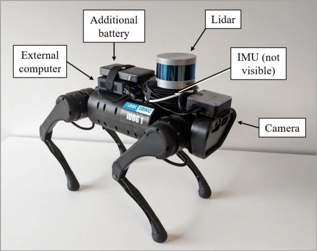
| 載具平台 | Unitree A1 ('IDOG' Intelligent DOcumentation Gadget) | 方法輸入 | 未標示 | quadruped carrying lidar, IMU, camera, external computer and extra battery; manually controlled in the office test | (Stührenberg & Smarsly, 2025, Sec. 4.5; Fig. 7; Table 4) |
| 運算硬體 | Intel NUC11TNKV7 | 執行運算平台 | 未標示 | Intel Core i7-1185G7, 32 GB RAM; used for both validation tests | (Stührenberg & Smarsly, 2025, Table 2; Table 4) |
| 其他 | AprilTag fiducial tags | 方法輸入 | 未標示 | printed tags placed at identical locations in the building and in the BIM (Revit AprilTag family exported as IfcBuildingElementProxy) | (Stührenberg & Smarsly, 2025, Sec. 3.2) |
論文圖片
只收錄原文以開放授權(open license)釋出的圖片,並依授權條件標示出處、圖號、授權與修改方式。
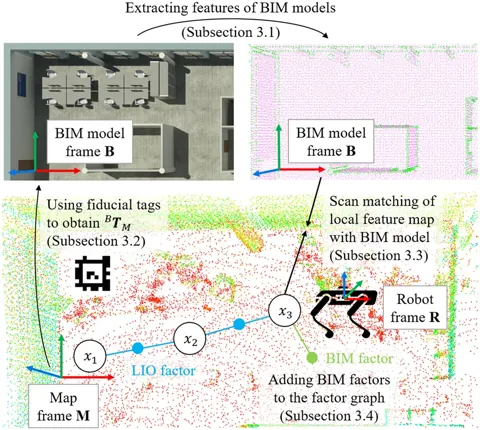
Fig. 1LIO-BIM 系統架構:光達慣性里程計、AprilTag 初始對齊與 BIM 掃描匹配
出處:Stührenberg & Smarsly, 2025,Fig. 1。授權:CC BY 4.0。原始圖檔。修改:縮小至寬度不超過 1400 px,並轉存為 WebP 格式。
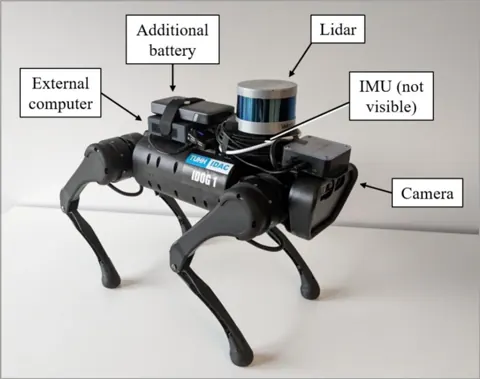
Fig. 7搭載 VLP-16、IMU 與相機的 IDOG 四足機器人
出處:Stührenberg & Smarsly, 2025,Fig. 7。授權:CC BY 4.0。原始圖檔。修改:轉存為 WebP 格式。
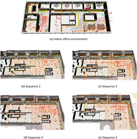
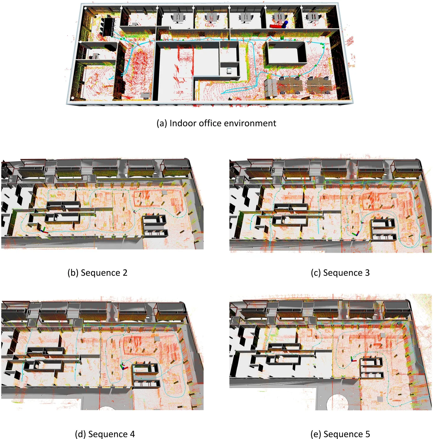
Fig. 11LIO-BIM 軌跡與點雲對齊 BIM 的結果(辦公室與 ConSLAM 序列 2 至 5)
出處:Stührenberg & Smarsly, 2025,Fig. 11。授權:CC BY 4.0。原始圖檔。修改:縮小至寬度不超過 1400 px,並轉存為 WebP 格式。
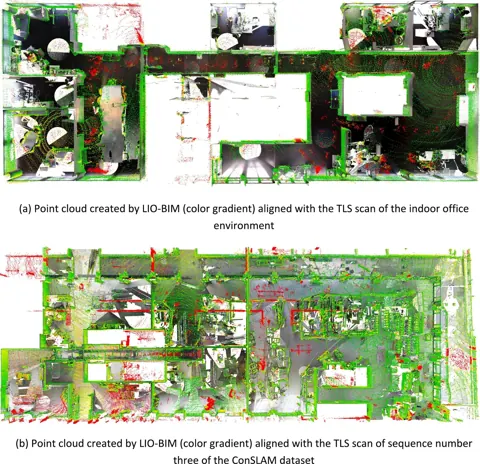
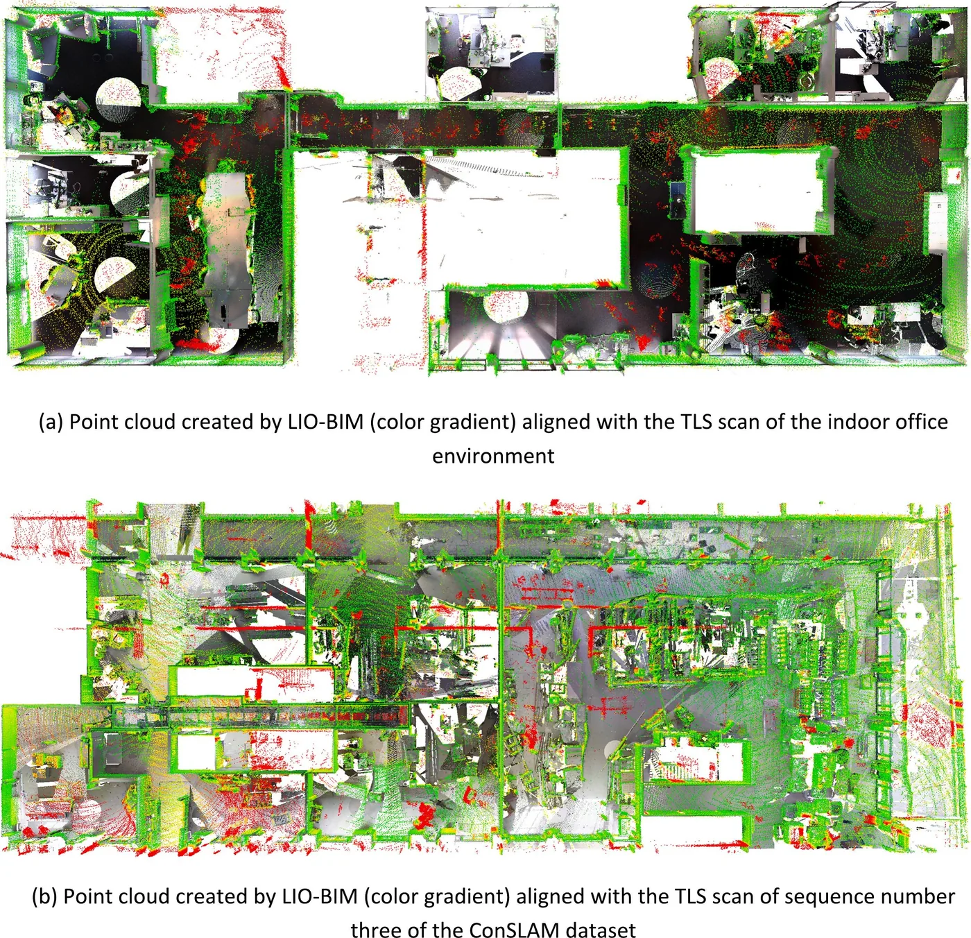
Fig. 13LIO-BIM 點雲與 TLS 掃描對齊,依點對點距離著色
出處:Stührenberg & Smarsly, 2025,Fig. 13。授權:CC BY 4.0。原始圖檔。修改:縮小至寬度不超過 1400 px,並轉存為 WebP 格式。
作者報告的優勢與限制
優勢
- ConSLAM translational APE RMSE 10.21-15.68 cm across sequences 2-5 vs ConSLAM ground truth (Table 5)
- against SLAM2REF ground truth, 5.97 cm (seq 2) and 12.57 cm vs 18.02 cm for LIO-SAM (seq 5) (Table 6)
- point-cloud inlier RMSE (0.3 m threshold) 6.3-7.9 cm vs TLS; office 6.57 cm vs 8.42 cm for LIO-SAM (Table 7)
- a wrongly placed wall in the office BIM did not corrupt the map because low-compliance matches were rejected (Sec. 6, Fig. 16)
- authors state the accuracy meets the +-10 cm needed for half-cell potential corrosion surveys except for a few outliers (Sec. 6)
- open-source code (GitHub)
限制
- not uniformly better than LIO-SAM: LIO-SAM had lower APE RMSE on ConSLAM sequences 3 and 4 against both ground truths (Tables 5-6) and lower inlier RMSE on sequences 3 and 4 (Table 7)
- error grows from 10.21 cm (seq 2) to 15.68 cm (seq 5, 4.5 months later) as the site departs from the BIM (Sec. 6)
- AprilTags must be placed manually at matching locations in the building and the BIM; BIM matching starts only after a tag is seen (Sec. 3.2, Sec. 7)
- parameters chosen experimentally; lidar reflections in windows create fictitious walls (Sec. 4.4, Sec. 6, Sec. 7, Fig. 15)
- BIM scan matching skips 23.6-33.1% of keyframes on ConSLAM because of processing time (Table 8)
- (inference) the ConSLAM BIM was derived from the TLS scan of sequence 2, so it is an as-built model and likely favours sequence 2
營建工程相關證據
以 ConSLAM(施工中建築資料集)驗證(摘要);另有辦公室實測。
原文驗證環境:已完工建築、公開基準、施工中工地、獨立參考量測
報告的性能數據
以下是原文作者報告的性能數值(author-reported results),不是本研究重新量測的結果。每張圖只並列同一個比較組(comparison group,同一張表、同一組實驗設定)內的方法;不同比較組之間的數值不可直接比較,也不構成排名。
本方法共出現在 6 個比較組,合計 111 筆紀錄。以下列出本方法紀錄最多的 4 組,其餘 2 組列在最後,並連到性能比較頁。
Stührenberg & Smarsly, 2025 · Table 8 本方法 30 筆
表格設定(擷取紀錄原文):Processing times recorded on the same Intel NUC11TNKV7 for both tests (office rosbag played back to LIO-BIM; ConSLAM sequences processed on the same computer); LIO-BIM only, no baseline timings (Stührenberg & Smarsly, 2025, Table 8)
processing time of scan matching with the BIM model per keyframe,own recording (IDOG quadruped) · indoor office environment (39 m x 16 m, 113 m trajectory)
這張表在此指標與資料序列只列出本方法一筆,沒有可並列的其他方法,因此不畫圖,數值與出處見下表。這是 Stührenberg & Smarsly, 2025 在此表設定下報告的數值(author-reported results),不代表方法在其他資料或設定下的表現。
| 方法(原文寫法) | 報告值 | 出處 |
|---|---|---|
| LIO-BIM本方法原文提出硬體:Intel NUC11TNKV7 (Intel Core i7-1185G7, 32 GB RAM) | 0.84947 s | (Stührenberg & Smarsly, 2025, Table 8) |
Stührenberg & Smarsly, 2025 · Table 9 本方法 30 筆
表格設定(擷取紀錄原文):Processing times recorded on the same Intel NUC11TNKV7 for both tests (office rosbag played back to LIO-BIM; ConSLAM sequences processed on the same computer); LIO-BIM only, no baseline timings (Stührenberg & Smarsly, 2025, Table 9)
processing time of lidar scan matching (LIO) per lidar frame (10 Hz lidar),own recording (IDOG quadruped) · indoor office environment (39 m x 16 m, 113 m trajectory)
這張表在此指標與資料序列只列出本方法一筆,沒有可並列的其他方法,因此不畫圖,數值與出處見下表。這是 Stührenberg & Smarsly, 2025 在此表設定下報告的數值(author-reported results),不代表方法在其他資料或設定下的表現。
| 方法(原文寫法) | 報告值 | 出處 |
|---|---|---|
| LIO-BIM本方法原文提出硬體:Intel NUC11TNKV7 (Intel Core i7-1185G7, 32 GB RAM) | 0.02836 s | (Stührenberg & Smarsly, 2025, Table 9) |
Stührenberg & Smarsly, 2025 · Table 5 本方法 16 筆
表格設定(擷取紀錄原文):APE of keyframe trajectories vs ConSLAM ground truth; trajectories aligned with Umeyama alignment (evo), scale handling not stated; ConSLAM sequence 1 excluded (faulty IMU) (Stührenberg & Smarsly, 2025, Table 5)
translational APE RMSE,ConSLAM · Sequence 2 (225 m)
只並列這張表在相同設定下報告的方法;以「本方法:」開頭者為本頁方法。失敗、未執行與未報告以標記呈現,不是 0。
按 Tab 進入圖表後,用上下方向鍵逐一瀏覽各類別,Esc 關閉提示框;也可開啟表格檢視閱讀全部數值。
這些是 Stührenberg & Smarsly, 2025 在此表設定下報告的數值(author-reported results),只能在同一個比較組內對照,不代表方法在其他資料或設定下的表現。
資料來源作者報告值(Stührenberg & Smarsly, 2025, Table 5)
| 方法(原文寫法) | 報告值 | 出處 |
|---|---|---|
| LIO-BIM本方法原文提出 | 10.21 cm | (Stührenberg & Smarsly, 2025, Table 5) |
| LIO-SAM | 27.28 cm | (Stührenberg & Smarsly, 2025, Table 5) |
Stührenberg & Smarsly, 2025 · Table 6 本方法 16 筆
表格設定(擷取紀錄原文):APE vs the ground-truth trajectories of SLAM2REF [17]; same runs as Table 5; alignment procedure for this comparison not separately stated (Stührenberg & Smarsly, 2025, Table 6)
translational APE RMSE,ConSLAM · Sequence 2 (225 m)
只並列這張表在相同設定下報告的方法;以「本方法:」開頭者為本頁方法。失敗、未執行與未報告以標記呈現,不是 0。
按 Tab 進入圖表後,用上下方向鍵逐一瀏覽各類別,Esc 關閉提示框;也可開啟表格檢視閱讀全部數值。
這些是 Stührenberg & Smarsly, 2025 在此表設定下報告的數值(author-reported results),只能在同一個比較組內對照,不代表方法在其他資料或設定下的表現。
資料來源作者報告值(Stührenberg & Smarsly, 2025, Table 6)
| 方法(原文寫法) | 報告值 | 出處 |
|---|---|---|
| LIO-BIM本方法原文提出 | 5.97 cm | (Stührenberg & Smarsly, 2025, Table 6) |
| LIO-SAM | 6.58 cm | (Stührenberg & Smarsly, 2025, Table 6) |
其他比較組
來源
Stührenberg & Smarsly, 2025
(2025)LIO-BIM – Coupling lidar inertial odometry with building information modeling for robot localization and mappingAdvanced Engineering Informatics, 66, 103477
DOI 10.1016/j.aei.2025.103477程式碼
同儕審查已出版已讀全文近十年查證後修正
相關版本
- 程式碼釋出:LIO-BIM repository (ROS 2, builds atop LIO-SAM) https://github.com/janstueh/LIO-BIM
程式碼:https://github.com/janstueh/LIO-BIM(授權:BSD-3-Clause (copyright Tixiao Shan 2020 and Jan Stührenberg 2025))。有公開程式碼不等於已被重現,也不代表目前版本與論文版本相同。