OGM2PGBM
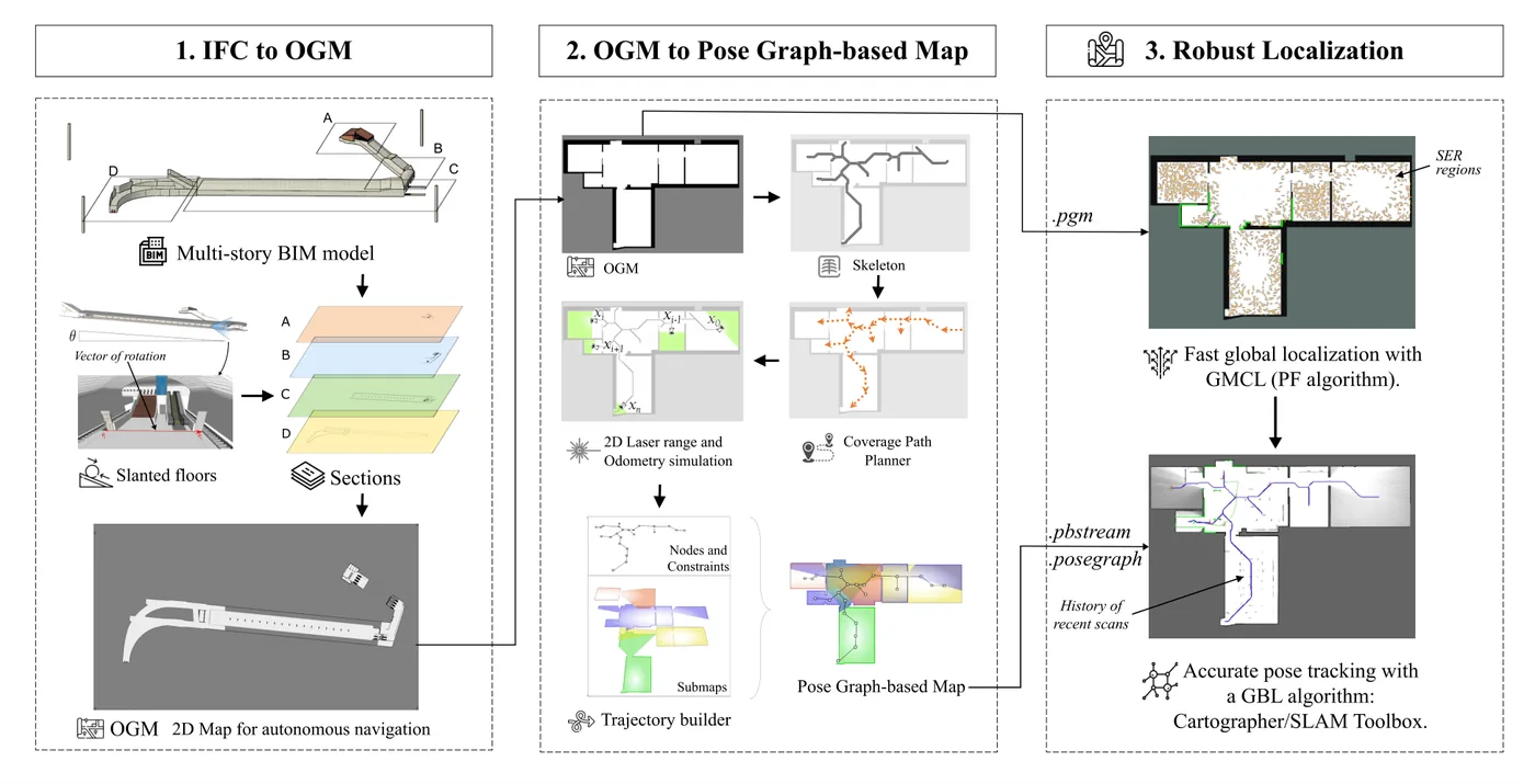
作者提出從 BIM 產生適合 2D LiDAR 定位的地圖,並比較不同定位器在 Scan-BIM 偏差下的表現。首先以 IfcConvert 在指定高度切出只含結構構件的 SVG 剖面,再用 OpenCV 輪廓階層區分室外、室內與障礙物,得到佔據格地圖;接著以骨架化與波前覆蓋路徑在可通行區域產生路點,不經 Gazebo 直接以光線投射模擬雷射掃描與里程計,組成 Cartographer 與 SLAM Toolbox 可讀的位姿圖地圖。作者在 Gazebo 中以空房間、依 TLS 資料建立的真實辦公室與災後雜亂三種情境(有無行人各一),比較 AMCL、GMCL 兩種粒子濾波與 Cartographer、SLAM Toolbox 兩種圖式定位的 RMSE 與全域定位收斂時間。
本頁內容
Generates occupancy grids from IFC models and converts them, via ray-cast virtual scans along coverage paths, into pose-graph maps for Cartographer and SLAM Toolbox; in Gazebo scenarios with increasing Scan-BIM deviation and walking agents, graph-based localizers track pose more accurately than AMCL and GMCL, while GMCL is best for global localization.
技術屬性
欄位內容為文獻擷取紀錄的原文用語(英文),以原文為據;「未查證」表示本研究尚未讀到該資訊,不代表該方法不具備此能力。
| 感測輸入 | 2D LiDAR (simulated Hokuyo UST-10LX)、simulated IMU and wheel odometry |
|---|---|
| 原文測試平台 | simulation (Robotnik SUMMIT-XL holonomic robot in Gazebo, about 1 m/s) |
| 狀態估計 | Compared localizers: particle filters AMCL and GMCL, and graph-based Cartographer (pure localization) and SLAM Toolbox using the generated pose-graph maps; proposed use: GMCL for global localization until covariance below 0.05, then switch to a graph-based localizer for pose tracking (Sec. 4.3) |
| 資料關聯 | scan matching of the respective localizers against OGM or pose-graph submaps (not modified by the authors) |
| 時間表示 | as in the compared localizers |
| 去畸變 | 不適用 (2D LiDAR in simulation) |
| 迴圈閉合 | 不適用 for pure localization; Cartographer and SLAM Toolbox constraints to the prior pose graph |
| 全域最佳化 | graph-based localizers optimize recent poses against the frozen prior pose graph; the prior graph needs no optimization because simulated scan poses are exact (Sec. 4.2) |
| 地圖表示 | 2D occupancy grid map extracted from IFC (IfcConvert SVG section, OpenCV contour hierarchy separating outdoor, indoor and obstacles) and a pose-graph map (.pbstream for Cartographer, .posegraph for SLAM Toolbox) built from ray-cast virtual scans along a skeleton-based wavefront coverage path (Sec. 4.1-4.2) |
| 先驗資訊 | as-designed IFC BIM model (multi-storey, slanted floors handled by rotation); non-permanent entities (spaces, windows, doors) excluded |
| 可輸出幾何 | 2D robot pose in the BIM frame; no point cloud produced |
| 計算需求 | 原文未報告 |
使用設備
原文使用的感測器、運算硬體與載具(equipment)。型號保留原文寫法,連結到設備頁中同一型號的歸併名稱;角色依原文用途分為方法輸入、資料集感測器、執行運算平台、參考或真值量測(reference or ground truth)與比較對象設備。
| 類別 | 型號(原文寫法) | 角色 | 資料集 | 原文規格 | 出處 |
|---|---|---|---|---|---|
| LiDAR | Hokuyo UST-10LX (simulated) | 方法輸入 | Gazebo simulation of the three BIM-based evaluation scenarios (building not named in the paper) | 2D LiDAR simulated in Gazebo; glass removed from collision models | (Torres et al., 2023, Sec. 5.2-5.3) |
| 慣性量測單元(IMU) | simulated IMU | 方法輸入 | Gazebo simulation of the three BIM-based evaluation scenarios (building not named in the paper) | simulated together with wheel odometry and ground truth odometry | (Torres et al., 2023, Sec. 5.3) |
| 輪式或腿式里程計 | simulated wheel odometry | 方法輸入 | Gazebo simulation of the three BIM-based evaluation scenarios (building not named in the paper) | simulated in the six sequences | (Torres et al., 2023, Sec. 5.3) |
| 載具平台 | Robotnik SUMMIT XL (simulated) | 方法輸入 | Gazebo simulation of the three BIM-based evaluation scenarios (building not named in the paper) | holonomic; commanded at about 1 m/s and 1 deg/s in Gazebo | (Torres et al., 2023, Sec. 5.3) |
論文圖片
只收錄原文以開放授權(open license)釋出的圖片,並依授權條件標示出處、圖號、授權與修改方式。
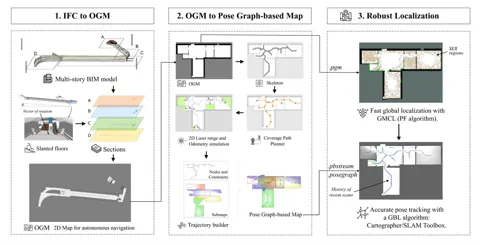
Figure 1由多層 BIM 產生佔據格地圖、轉為位姿圖地圖並用於全域定位與位姿追蹤的整體流程
出處:Torres et al., 2023,Figure 1。授權:CC BY 4.0。原始圖檔。修改:縮小至寬度不超過 1400 px,並轉存為 WebP 格式。
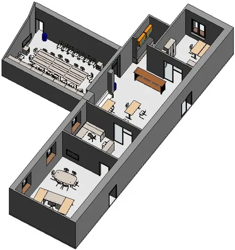
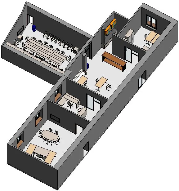
Figure 2 (b)評估情境二:依真實 TLS 資料建立的一般辦公室環境
出處:Torres et al., 2023,Figure 2 (b)。授權:CC BY 4.0。原始圖檔。修改:轉存為 WebP 格式。
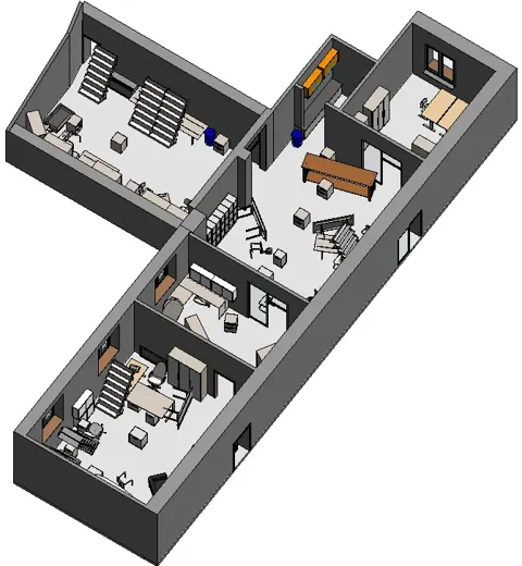
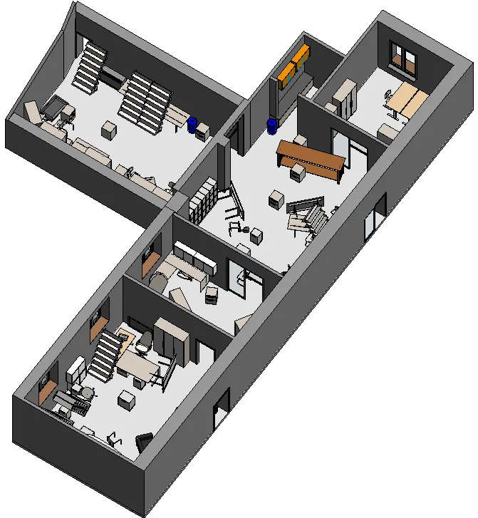
Figure 2 (c)評估情境三:模擬災後、Scan-BIM 偏差很大的環境
出處:Torres et al., 2023,Figure 2 (c)。授權:CC BY 4.0。原始圖檔。修改:轉存為 WebP 格式。
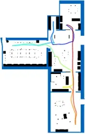
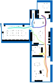
Figure 3 (c)序列 2-1 的佔據格地圖與機器人軌跡,空房間地圖以藍色疊合顯示 Scan-BIM 偏差
出處:Torres et al., 2023,Figure 3 (c)。授權:CC BY 4.0。原始圖檔。修改:轉存為 WebP 格式。
作者報告的優勢與限制
優勢
- In the office scenario with medium Scan-BIM deviation, Cartographer with the generated pose-graph map reached 7.19 cm translational RMSE versus 33.68 cm for AMCL (Table 1; Abstract)
- Graph-based localizers outperformed particle filters for pose tracking in all evaluated sequences (Sec. 6.1)
- Pose-graph maps are generated without Gazebo, making the pipeline faster and more portable; works from any OGM (Sec. 4.2)
- OGM extraction handles complex multi-storey, non-convex models with slanted floors (Sec. 4.1)
限制
- Cartographer failed in the Disaster scenario because of wrong data associations (Table 1; Sec. 6.1)
- No method converged for global localization in the Disaster scenario; AMCL did not converge in scenario 2-1 (Sec. 6.2)
- SLAM Toolbox provides no global localization service and its lifelong mode performed poorly (Sec. 5.4)
- Only 2D LiDAR; 3D LiDAR and multi-sensor fusion are future work (Sec. 8)
營建工程相關證據
針對設計 BIM 與竣工現況不一致(家具、施工偏差、動態人員)時的 2D LiDAR 定位,量化粒子濾波與圖式定位的差異;結果全部來自 Gazebo 模擬,其中第二情境依真實辦公室的 TLS 資料建立(Sec. 5、Table 1)。
原文驗證環境:模擬
報告的性能數據
以下是原文作者報告的性能數值(author-reported results),不是本研究重新量測的結果。每張圖只並列同一個比較組(comparison group,同一張表、同一組實驗設定)內的方法;不同比較組之間的數值不可直接比較,也不構成排名。
本方法共出現在 1 個比較組,合計 12 筆紀錄。
Torres et al., 2023 · Table 1 本方法 12 筆
表格設定(擷取紀錄原文):Pose tracking in Gazebo with a Robotnik SUMMIT-XL and Hokuyo UST-10LX; maps from an as-designed IFC model; three scenarios with increasing Scan-BIM deviation, with and without walking human agents; PF methods averaged over 30 runs; RMSE against simulator ground truth computed with evo and rpg trajectory evaluation; '-' = Cartographer found wrong associations and failed (Torres et al., 2023, Table 1)
translational RMSE,Gazebo simulation from an as-designed IFC model, three scenarios (building not named in the paper) · 1-1 (Empty Room, no dynamic agents)
只並列這張表在相同設定下報告的方法;以「本方法:」開頭者為本頁方法。失敗、未執行與未報告以標記呈現,不是 0。
按 Tab 進入圖表後,用上下方向鍵逐一瀏覽各類別,Esc 關閉提示框;也可開啟表格檢視閱讀全部數值。
這些是 Torres et al., 2023 在此表設定下報告的數值(author-reported results),只能在同一個比較組內對照,不代表方法在其他資料或設定下的表現。
資料來源作者報告值(Torres et al., 2023, Table 1)
| 方法(原文寫法) | 報告值 | 出處 |
|---|---|---|
| AMCL | 8.49 cm | (Torres et al., 2023, Table 1) |
| GMCL | 8.27 cm | (Torres et al., 2023, Table 1) |
| SLAM Toolbox (localization with prior .posegraph from OGM2PGBM)本方法原文提出 | 3.69 cm | (Torres et al., 2023, Table 1) |
| Cartographer (pure localization with .pbstream from OGM2PGBM)原文提出 | 4.01 cm | (Torres et al., 2023, Table 1) |
來源
Torres et al., 2023
(2023)OGM2PGBM: Robust BIM-based 2D-LiDAR localization for lifelong indoor navigationECPPM 2022: eWork and eBusiness in Architecture, Engineering and Construction 2022 (CRC Press), pp. 567-574
DOI 10.1201/9781003354222-72arXiv 2308.05443程式碼
同儕審查已出版已讀全文近十年查證後修正
相關版本
- 預印本:arXiv 2308.05443 v1 (posted after the chapter, longer title) https://arxiv.org/abs/2308.05443
- repository copy:mediaTUM record https://mediatum.ub.tum.de/1688028
- 程式碼釋出:MigVega/Ogm2Pgbm https://github.com/MigVega/Ogm2Pgbm
程式碼:https://github.com/MigVega/Ogm2Pgbm(授權:MIT (LICENSE file on main branch checked 2026-09-25))。有公開程式碼不等於已被重現,也不代表目前版本與論文版本相同。