SLAM2REF
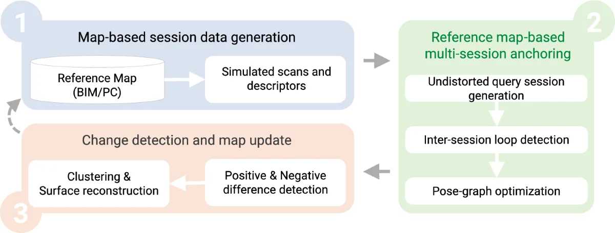
SLAM2REF 把行動 LiDAR 與 IMU 資料和既有 BIM 或點雲參考圖整合,用於室內無 GPS 環境的長期建圖。流程先由參考圖產生佔據網格與模擬 LiDAR 掃描作為「參考工作段」,再以 DLIO 去除實測掃描的運動畸變,接著用室內版 Scan Context 描述子與 YawGICP 找跨工作段對應,透過多工作段錨定(multi-session anchoring)位姿圖最佳化把漂移的 SLAM 結果對齊參考圖,最後逐幀以點對點 ICP 對齊 1 cm 密度的參考點雲。對齊後以 OctoMap 分析新增與移除的構件並網格化,並允許地圖延伸到參考圖範圍之外。
本頁內容
SLAM2REF aligns drifted LiDAR-inertial sessions to a BIM or TLS reference map through simulated reference sessions, Indoor Scan Context, YawGICP, multi-session anchoring and a final dense ICP, then detects positive and negative changes and extends the map.
技術屬性
欄位內容為文獻擷取紀錄的原文用語(英文),以原文為據;「未查證」表示本研究尚未讀到該資訊,不代表該方法不具備此能力。
| 感測輸入 | 3D LiDAR of the ConSLAM handheld system (model not reported; the ISC descriptor requires a 360-degree horizontal FoV)、9-axis IMU of the ConSLAM handheld system (model not reported; used for DLIO deskewing; LiDAR-IMU extrinsics from OA-LICalib) |
|---|---|
| 原文測試平台 | handheld (ConSLAM sequences) |
| 狀態估計 | DLIO front end for deskewing and odometry; multi-session anchoring pose graph in GTSAM (iSAM2, batch) with odometry, Indoor Scan Context and KNN inter-session constraints; final point-to-point ICP of each scan to a 1 cm dense reference cloud (Sec. 4.2, 5.2) |
| 資料關聯 | Indoor Scan Context descriptors (binary occupancy per bin, 60 sectors x 20 rings, at least 40 points, 10 m radius) matched against simulated reference scans: 100 top candidates from a nanoflann KD-tree of rotation-invariant 1D descriptors, column-wise cosine score with threshold 0.3 and yaw shifts limited to 36 deg, then YawGICP (built on Open3D GICP) against 3-scan reference submaps; KNN submap loops (K = 5) with adaptive covariance, omitted for BIM references; final point-to-point ICP to a 1 cm dense reference cloud with fitness at 1 cm and 3 cm computed on points within 30 cm (Sec. 4.2.2, 4.2.3, 5.2.2) |
| 時間表示 | continuous-time deskew inherited from DLIO (constant jerk and angular acceleration with IMU); discrete keyframe poses in the pose graph (Sec. 4.2.1.1) |
| 去畸變 | IMU-based point-wise motion correction using DLIO; bags replayed at half speed to avoid deskew errors (Sec. 4.2.1.1, 5.2.2.1) |
| 迴圈閉合 | inter-session loops to reference-map sessions (ISC, then KNN); intra-session loops optional from the SLAM front end (Sec. 4.2) |
| 全域最佳化 | multi-session anchoring pose-graph optimization, then per-scan final ICP to the dense reference cloud (Sec. 4.2.3) |
| 地圖表示 | point cloud; OctoMap for dynamic-object removal and free-space reasoning; voxel-cube meshes for positive and negative differences (Sec. 4.3) |
| 先驗資訊 | BIM (IFC, filtered to permanent elements such as walls, columns, slabs and floors; doors and windows excluded) or TLS point cloud as reference map; occupancy grid from IfcConvert SVG sections, and Blensor-simulated 360-deg scans at skeleton-sampled locations (vertical FoV -45 to 45 deg for TLS references, 0 to -25 deg without ceiling for BIM; noise std 0.03 m, angular resolution 0.1728 deg, max range 15 m) (Sec. 4.1, 5.2.1) |
| 可輸出幾何 | 6-DoF poses in the reference-map frame with per-scan alignment classes (perfect, good, bad, outside map); aligned and extended point cloud map; meshes of positive and negative differences (Sec. 4.2.3, 4.3) |
| 計算需求 | offline, not real-time; the final ICP stage can take several dozen minutes (Sec. 8); Step 2 in C++ with OpenMP (parallel YawGICP and final ICP), Steps 1 and 3 in Python (Trimesh, OctoMap, Open3D); GTSAM iSAM2; compute hardware not reported (Sec. 5.2) |
使用設備
原文使用的感測器、運算硬體與載具(equipment)。型號保留原文寫法,連結到設備頁中同一型號的歸併名稱;角色依原文用途分為方法輸入、資料集感測器、執行運算平台、參考或真值量測(reference or ground truth)與比較對象設備。
| 類別 | 型號(原文寫法) | 角色 | 資料集 | 原文規格 | 出處 |
|---|---|---|---|---|---|
| LiDAR | 原文未報告 (3D LiDAR of the ConSLAM handheld system) | 方法輸入 | ConSLAM | scans deskewed with DLIO; rosbags replayed at half speed; method assumes 360-deg horizontal FoV | (Vega-Torres et al., 2024, Sec. 5.1, 5.2.2, 8) |
| 地面雷射掃描儀(TLS) | 原文未報告 (TLS point clouds supplied with ConSLAM) | 參考或真值量測 | ConSLAM | per-sequence TLS clouds used as reference maps; S2 TLS cloud used to model a half-centimetre-accurate BIM | (Vega-Torres et al., 2024, Sec. 1, 5.1, 6) |
| 慣性量測單元(IMU) | 原文未報告 (9-axis IMU of the ConSLAM handheld system) | 方法輸入 | ConSLAM | 9-axis; LiDAR-IMU extrinsics estimated with OA-LICalib | (Vega-Torres et al., 2024, Sec. 5.1) |
| 相機 | 原文未報告 (RGB camera of the ConSLAM handheld system) | 資料集感測器 | ConSLAM | 原文未報告; not used by SLAM2REF | (Vega-Torres et al., 2024, Sec. 5.1) |
| 相機 | 原文未報告 (near-infrared camera of the ConSLAM handheld system) | 資料集感測器 | ConSLAM | 原文未報告; not used by SLAM2REF | (Vega-Torres et al., 2024, Sec. 5.1) |
| 載具平台 | handheld system (model not reported) | 資料集感測器 | ConSLAM | four construction-site sequences S2-S5 of 225-340 m | (Vega-Torres et al., 2024, Sec. 5.1, Table 1) |
論文圖片
只收錄原文以開放授權(open license)釋出的圖片,並依授權條件標示出處、圖號、授權與修改方式。
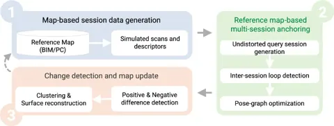
Fig. 1SLAM2REF 三步驟流程總覽:由參考圖產生工作段資料、參考圖多工作段錨定、變化偵測與地圖更新。
出處:Vega-Torres et al., 2024,Fig. 1。授權:CC BY 4.0。原始圖檔。修改:轉存為 WebP 格式。
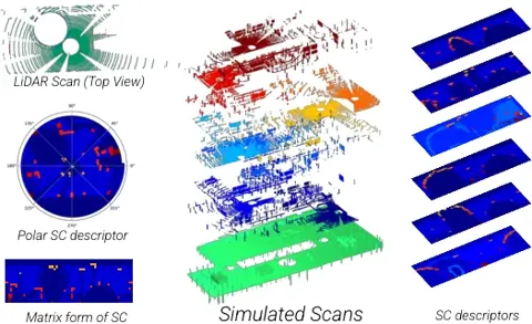
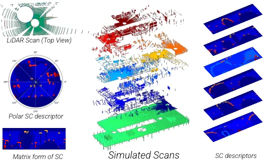
Fig. 4由 BIM 網格模擬的 LiDAR 掃描與對應的 Scan Context 描述子,構成合成的參考工作段。
出處:Vega-Torres et al., 2024,Fig. 4。授權:CC BY 4.0。原始圖檔。修改:轉存為 WebP 格式。
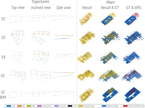
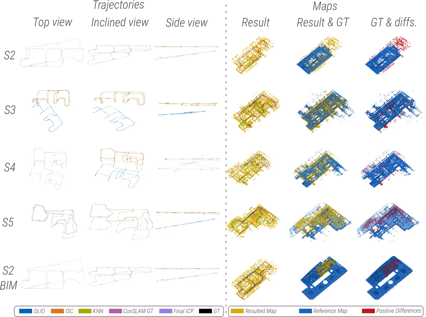
Fig. 13ConSLAM 序列 2 至 5 對齊 TLS 點雲,以及序列 2 對齊 BIM 後的軌跡、點雲地圖與新增元素。
出處:Vega-Torres et al., 2024,Fig. 13。授權:CC BY 4.0。原始圖檔。修改:縮小至寬度不超過 1400 px,並轉存為 WebP 格式。
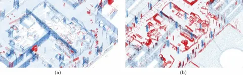
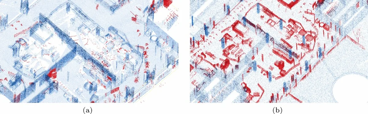
Fig. 14序列 2 對齊後的變化偵測結果:圖 a 與 TLS 點雲比較,圖 b 與 BIM 比較,新增元素以紅色標示。
出處:Vega-Torres et al., 2024,Fig. 14。授權:CC BY 4.0。原始圖檔。修改:轉存為 WebP 格式。
作者報告的優勢與限制
優勢
- Automatic alignment without manual initialization of the first keyframe, unlike ground-truth generation in ConSLAM or Newer College (Sec. 7)
- Alignment to a clutter-free BIM despite scan-map deviations from clutter, furniture and dynamic objects (Sec. 1, 6)
- Not restricted to Manhattan-world layouts; supports extending the reference map (Sec. 7)
限制
- Sensitive to the initial SLAM or LIO poses; large drift, especially Z-drift in narrow corridors without floor or ceiling points, may not be corrected (Sec. 8, Fig. 15)
- Large deviations of permanent walls or columns, low overlap or symmetric environments can defeat alignment; the final ICP may be wrong where the reference map is wrong (Sec. 8)
- Not real-time; final ICP can take several dozen minutes (Sec. 8)
- Indoor Scan Context needs a 360-degree horizontal FoV, so solid-state LiDARs and depth cameras are not directly supported (Sec. 8)
- Window reflections create fictitious elements in change detection (Sec. 8)
- Only clutter and dynamic-object deviations are addressed, not alterations of permanent building elements (Sec. 1)
- After the KNN loops, rotational APE rises in S3 and S5 (Table 1, Sec. 6); Sec. 7 explains this pattern (naming it for sequences 2 and 5 there) by erroneous KNN loops detected where the ISC-aligned trajectory, before Umeyama alignment, still deviated about 1.5 m in Z and X from the ground truth; the final ICP filters these loops (Sec. 6, Sec. 7, Table 1)
- Correct ISC correspondences are very sensitive to the number of top candidates (N_c = 100) (Sec. 5.2.2)
- (inference) Final-ICP poses to the TLS map serve as ground truth, so the TLS-referenced final stage is not independently evaluated
- (inference) The ConSLAM BIM was modelled from the TLS point cloud of sequence 2 (Sec. 5.1), i.e. an as-built model, so design-versus-as-built discrepancy (brief Sec. 11 risk 2) is not tested; the same caveat is recorded for Stührenberg & Smarsly, 2025 in C11b
營建工程相關證據
以 ConSLAM 施工中建物資料集(手持設備、四個序列)驗證,並以 seq 2 的 TLS 建立約半公分精度的 BIM(as-built,非設計模型)。延續(Vega Torres et al., 2023)的 BIM-SLAM 路線;作者說明相較 BIM-SLAM 增加大型參考圖、IMU 去畸變、最終 ICP 與容許掃描-地圖差異的能力(Sec. 7)。
原文驗證環境:施工中工地、公開基準
報告的性能數據
以下是原文作者報告的性能數值(author-reported results),不是本研究重新量測的結果。每張圖只並列同一個比較組(comparison group,同一張表、同一組實驗設定)內的方法;不同比較組之間的數值不可直接比較,也不構成排名。
本方法共出現在 2 個比較組,合計 22 筆紀錄。
Vega-Torres et al., 2024 · Table 1 本方法 20 筆
表格設定(擷取紀錄原文):ConSLAM S2-S5 aligned to the per-sequence TLS point cloud; APE RMSE against the SLAM2REF final-ICP poses, which the authors use as ground truth; evo, TUM format, Umeyama alignment (scale handling not stated) (Vega-Torres et al., 2024, Table 1)
translational APE RMSE,ConSLAM · S2 (225 m)
只並列這張表在相同設定下報告的方法;以「本方法:」開頭者為本頁方法。失敗、未執行與未報告以標記呈現,不是 0。
按 Tab 進入圖表後,用上下方向鍵逐一瀏覽各類別,Esc 關閉提示框;也可開啟表格檢視閱讀全部數值。
這些是 Vega-Torres et al., 2024 在此表設定下報告的數值(author-reported results),只能在同一個比較組內對照,不代表方法在其他資料或設定下的表現。
資料來源作者報告值(Vega-Torres et al., 2024, Table 1)
| 方法(原文寫法) | 報告值 | 出處 |
|---|---|---|
| DLIO | 20.2 cm | (Vega-Torres et al., 2024, Table 1) |
| SC (DLIO after Indoor Scan Context loop detection and optimization; SLAM2REF intermediate stage)本方法原文提出 | 20.1 cm | (Vega-Torres et al., 2024, Table 1) |
| KNN (after KNN loops and optimization; SLAM2REF intermediate stage)本方法原文提出 | 9 cm | (Vega-Torres et al., 2024, Table 1) |
| ConSLAM (ground-truth poses supplied with the dataset) | 5.2 cm | (Vega-Torres et al., 2024, Table 1) |
Vega-Torres et al., 2024 · Text Sec.6 本方法 2 筆
資料集與序列ConSLAM · S2 (225 m)
表格設定(擷取紀錄原文):ConSLAM S2 aligned to a BIM modelled from the S2 TLS cloud; APE RMSE after the final ICP against the TLS-derived reference poses (Vega-Torres et al., 2024, Text Sec.6)
translational APE RMSE,ConSLAM · S2 (225 m)
這張表在此指標與資料序列只列出本方法一筆,沒有可並列的其他方法,因此不畫圖,數值與出處見下表。這是 Vega-Torres et al., 2024 在此表設定下報告的數值(author-reported results),不代表方法在其他資料或設定下的表現。
| 方法(原文寫法) | 報告值 | 出處 |
|---|---|---|
| SLAM2REF with BIM reference (after final ICP)本方法原文提出 | 14.8 cm | (Vega-Torres et al., 2024, Sec. 6, Fig. 12) |
來源
Vega-Torres et al., 2024
(2024)SLAM2REF: advancing long-term mapping with 3D LiDAR and reference map integration for precise 6-DoF trajectory estimation and map extensionConstruction Robotics, 8(2), article 13
DOI 10.1007/s41693-024-00126-warXiv 2408.15948程式碼
同儕審查已出版已讀全文近十年查證後修正
相關版本
- 預印本:arXiv 2408.15948 v1 (posted 2024-08-28, after journal publication; journal_ref Construction Robotics 2024) https://arxiv.org/abs/2408.15948
- 程式碼釋出:SLAM2REF repository (GPL-3.0) https://github.com/MigVega/SLAM2REF
- 資料集:ConSLAM BIM and GT Poses (dataset, TUM mediaTUM, 2024) 10.14459/2024mp1743877
程式碼:https://github.com/MigVega/SLAM2REF(授權:GPL-3.0)。有公開程式碼不等於已被重現,也不代表目前版本與論文版本相同。