Lifelong 3D Mapping Framework (hand-held & robot-mounted)
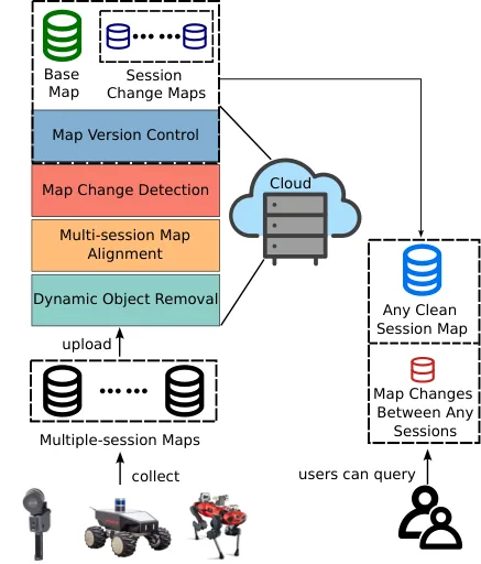
此框架針對手持與機器人搭載光達建圖系統,串接四個模組:以 OctoMap 為基礎,加入子地圖多平面 RANSAC 回填、K 近鄰投票與半徑搜尋後處理的動態點移除;以 PCA-SHOT 特徵配對與 RANSAC 粗對齊、再以 NDT 精配準的多時段地圖對齊(六個參數以網格搜尋並取 Chamfer 距離最小者);先以 k 近鄰半徑搜尋區分共存、重疊與非重疊區域,再比較沿平面法向投影的 2D 俯視最大高度描述子,找出正負變化;最後以類似 Git 的版本控制只保存一張基準地圖、各時段正負差異與邊界點,可重建任一時段乾淨地圖並查詢任兩時段差異。
本頁內容
A modular, cloud-native lifelong mapping pipeline for handheld and robot LiDAR maps: OctoMap-based dynamic removal with plane refilling, PCA-SHOT+RANSAC then NDT map alignment with grid-searched parameters, change detection by radius-based overlap splitting plus comparison of 2D bird's-eye-view max-height descriptors, and Git-style map version control storing one base map, differences and session boundaries.
技術屬性
欄位內容為文獻擷取紀錄的原文用語(英文),以原文為據;「未查證」表示本研究尚未讀到該資訊,不代表該方法不具備此能力。
| 感測輸入 | 3D LiDAR |
|---|---|
| 原文測試平台 | handheld、vehicle、wheeled UGV |
| 狀態估計 | 不適用 (poses supplied by external SLAM or commercial device software) |
| 資料關聯 | PCA-SHOT keypoint descriptors with RANSAC for initial alignment, then NDT fine registration; grid search over six parameters selected by lowest Chamfer distance |
| 時間表示 | 不適用 |
| 去畸變 | 原文未報告 |
| 迴圈閉合 | none (map-to-map rigid alignment) |
| 全域最佳化 | none (rigid alignment of whole session maps) |
| 地圖表示 | clean static session maps; single base map plus stored positive/negative changes and boundary points (version control) |
| 先驗資訊 | previous session maps |
| 可輸出幾何 | clean static maps, aligned maps, positive/negative change point sets, reconstructable past session maps |
| 計算需求 | Dynamic removal takes approximately 1.5 h for the whole KITTI 00 sequence (4500 frames as printed) on the authors' PC with an AMD Ryzen 9 3900x CPU (no GPU mentioned), stated as 1.5 times faster than Ground-Octomap (Sec. IV-A); grid-searched alignment takes roughly 3 min for XGrid-Outdoor maps of about 10M points versus over 10 min for LT-SLAM (Sec. IV-B); change detection takes about 2 min on LT-ParkingLot with 0.8M points (Sec. IV-C); hardware for the last two timings not stated; cloud-native design (abstract) |
使用設備
原文使用的感測器、運算硬體與載具(equipment)。型號保留原文寫法,連結到設備頁中同一型號的歸併名稱;角色依原文用途分為方法輸入、資料集感測器、執行運算平台、參考或真值量測(reference or ground truth)與比較對象設備。
| 類別 | 型號(原文寫法) | 角色 | 資料集 | 原文規格 | 出處 |
|---|---|---|---|---|---|
| 行動掃描設備 | XGrids hand-held LiDAR mapping device (model not reported) | 方法輸入 | XGrid-Outdoor, XGrid-Parking | commercial hand-held LiDAR mapping device; session poses retrieved from XGrids proprietary software | (Yang et al., 2024, Abstract; Sec. IV; Sec. IV-B) |
| 運算硬體 | AMD Ryzen 9 3900x歸入:AMD RYZEN 9 3900X | 執行運算平台 | 未標示 | CPU of the authors' PC used for the dynamic removal timing | (Yang et al., 2024, Sec. IV-A) |
論文圖片
只收錄原文以開放授權(open license)釋出的圖片,並依授權條件標示出處、圖號、授權與修改方式。
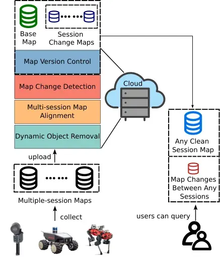
Fig. 1系統概念圖:使用者上傳多時段三維地圖,經動態物件移除、多時段對齊、變化偵測與版本控制後,可取回任一時段乾淨地圖或查詢任兩時段差異
出處:Yang et al., 2024,Fig. 1。授權:CC BY-NC-SA 4.0。原始圖檔。修改:轉存為 WebP 格式。
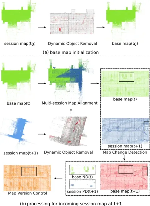
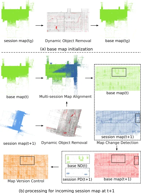
Fig. 4以 XGrid-Parking 手持光達資料說明完整流程:基準地圖初始化、新時段地圖的動態點移除與對齊,以及正負變化反映到更新後的基準地圖
出處:Yang et al., 2024,Fig. 4。授權:CC BY-NC-SA 4.0。原始圖檔。修改:轉存為 WebP 格式。
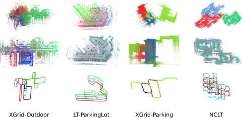
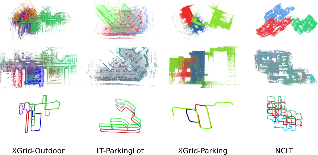
Fig. 5LT-ParkingLot、XGrid-Parking、XGrid-Outdoor 與 NCLT 的多時段地圖對齊結果,以高度差區分不同時段軌跡
出處:Yang et al., 2024,Fig. 5。授權:CC BY-NC-SA 4.0。原始圖檔。修改:轉存為 WebP 格式。
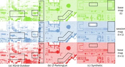
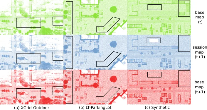
Fig. 7XGrid-Outdoor、LT-ParkingLot 與合成資料的變化偵測視覺化:移除消失的樹與車、加入新物件,並保留被遮蔽區域
出處:Yang et al., 2024,Fig. 7。授權:CC BY-NC-SA 4.0。原始圖檔。修改:轉存為 WebP 格式。
作者報告的優勢與限制
優勢
- Works with commercial handheld (XGrids) and open-source robot SLAM outputs (abstract; Sec. IV)
- Alignment needs no manual parameter tuning thanks to grid search (abstract; Sec. III-C)
- Past session maps reconstructable without storing raw session maps (abstract; Sec. III-E)
- Map version control storage is 40.1% to 94.2% smaller than storing all input maps, reaching 94.2% on 27 NCLT sessions over about 1.5 years (Table V)
- Change detection mean precision 0.885 (PD) and 0.920 (ND) versus 0.711 and 0.739 for KNN and 0.654 and 0.692 for PCL-OC, with comparable recall (Table IV)
- Occluded regions missing in a new session are kept from the base map rather than deleted (Sec. IV-C, Figs. 4 and 7)
限制
- Most parameter subsets fail at feature matching and are discarded, so alignment relies on exhaustive search (Sec. III-C)
- (inference) Chamfer distance is used both to select the alignment and to report alignment quality, so the reported metric is not independent of the selection
- (inference) Rigid whole-map alignment cannot correct intra-session drift or deformation, unlike pose-graph or BA approaches
- About 1 to 3% of static points remain misclassified as dynamic because not all areas are revisited during mapping (Sec. III-B)
- The optional height filter may not work for drone mapping or hand-held mapping in multi-storey buildings without additional consistency checks (Sec. III-B)
- Rejection rate is roughly 3% lower than ERASOR on SemanticKITTI (Sec. IV-A, Table II)
- Quantitative change detection uses manually introduced changes as ground truth; ND recall on XGrid-Outdoor (0.798) is below both baselines, and PD precision on MulRan DCC (0.769) is below KNN (0.836) (Sec. IV-C, Table IV)
營建工程相關證據
以商用手持光達(XGrids)於戶外與室內停車場多時段測試(Sec. IV-B),並報告 LT-SLAM 因 Scan Context 無法在重複室內停車場辨識迴圈而失敗;作者也指出可選的高度濾波不一定適用於多樓層建築的手持建圖(Sec. III-B)。變化偵測的量化評估使用人工移動物件產生的模擬變化(Sec. IV-C)。此為手持設備重複掃描的直接證據,但非工地、亦無獨立參考量測(推論:適合檢驗營建重複巡檢與差異追蹤流程,仍需工地實測驗證)。
原文驗證環境:公開基準、跨場域
報告的性能數據
以下是原文作者報告的性能數值(author-reported results),不是本研究重新量測的結果。每張圖只並列同一個比較組(comparison group,同一張表、同一組實驗設定)內的方法;不同比較組之間的數值不可直接比較,也不構成排名。
本方法共出現在 7 個比較組,合計 50 筆紀錄。以下列出本方法紀錄最多的 4 組,其餘 3 組列在最後,並連到性能比較頁。
Yang et al., 2024 · Table IV 本方法 20 筆
表格設定(擷取紀錄原文):Map change detection against manually introduced changes (relocated buildings, cars, trees); precision and recall for positive differences (PD, new data in session map) and negative differences (ND, data gone from base map); baselines are a k-d tree change detector (KNN) and the Point Cloud Library octree change detector (PCL-OC); a detected point counts as true if a ground truth change lies in its small radial neighbourhood (Yang et al., 2024, Table IV)
PD precision,XGrid-Outdoor · simulated changes
只並列這張表在相同設定下報告的方法;以「本方法:」開頭者為本頁方法。失敗、未執行與未報告以標記呈現,不是 0。
按 Tab 進入圖表後,用上下方向鍵逐一瀏覽各類別,Esc 關閉提示框;也可開啟表格檢視閱讀全部數值。
這些是 Yang et al., 2024 在此表設定下報告的數值(author-reported results),只能在同一個比較組內對照,不代表方法在其他資料或設定下的表現。
資料來源作者報告值(Yang et al., 2024, Table IV)
| 方法(原文寫法) | 報告值 | 出處 |
|---|---|---|
| KNN | 0.747 ratio | (Yang et al., 2024, Table IV) |
| PCL-OC | 0.559 ratio | (Yang et al., 2024, Table IV) |
| Ours本方法原文提出 | 0.968 ratio | (Yang et al., 2024, Table IV) |
Yang et al., 2024 · Table II 本方法 18 筆
表格設定(擷取紀錄原文):Dynamic object removal on SemanticKITTI; point-wise labels, moving classes counted as dynamic; sequences and scan ranges follow the ERASOR setup; authors note ERASOR ran at a lower frame rate; baseline execution settings otherwise not stated (Yang et al., 2024, Table II)
PR (preservation rate),SemanticKITTI · 00
只並列這張表在相同設定下報告的方法;以「本方法:」開頭者為本頁方法。失敗、未執行與未報告以標記呈現,不是 0。
按 Tab 進入圖表後,用上下方向鍵逐一瀏覽各類別,Esc 關閉提示框;也可開啟表格檢視閱讀全部數值。
這些是 Yang et al., 2024 在此表設定下報告的數值(author-reported results),只能在同一個比較組內對照,不代表方法在其他資料或設定下的表現。
資料來源作者報告值(Yang et al., 2024, Table II)
| 方法(原文寫法) | 報告值 | 出處 |
|---|---|---|
| ERASOR | 0.9172 ratio | (Yang et al., 2024, Table II) |
| Removert | 0.9328 ratio | (Yang et al., 2024, Table II) |
| Ground-Octomap | 0.7765 ratio | (Yang et al., 2024, Table II) |
| Ours本方法原文提出 | 0.9471 ratio | (Yang et al., 2024, Table II) |
Yang et al., 2024 · Table III 本方法 5 筆
指標Chamfer distance after multi-session map alignment
表格設定(擷取紀錄原文):Average Chamfer distance after aligning several session maps into one frame; poses from XGrids proprietary software (XGrid datasets) or SC-LIO-SAM and SC-A-LOAM (LT-ParkingLot, MulRan); outlier threshold tau 0.5; the proposed method also uses Chamfer distance to pick its alignment (Yang et al., 2024, Table III)
Chamfer distance after multi-session map alignment,XGrid-Outdoor · 6 session maps
只並列這張表在相同設定下報告的方法;以「本方法:」開頭者為本頁方法。失敗、未執行與未報告以標記呈現,不是 0。
按 Tab 進入圖表後,用上下方向鍵逐一瀏覽各類別,Esc 關閉提示框;也可開啟表格檢視閱讀全部數值。
這些是 Yang et al., 2024 在此表設定下報告的數值(author-reported results),只能在同一個比較組內對照,不代表方法在其他資料或設定下的表現。
資料來源作者報告值(Yang et al., 2024, Table III)
| 方法(原文寫法) | 報告值 | 出處 |
|---|---|---|
| Ours本方法原文提出 | 0.069 | (Yang et al., 2024, Table III) |
| LT-SLAM | 0.0862 | (Yang et al., 2024, Table III) |
| ICP | 0.1389 | (Yang et al., 2024, Table III) |
| NDT | 0.1342 | (Yang et al., 2024, Table III) |
Yang et al., 2024 · Table V 本方法 4 筆
指標Ours (MB)
表格設定(擷取紀錄原文):Memory to store all input downsampled session maps versus the map version control store (base map, positive and negative differences, boundaries); NCLT downsampled to 0.5 m, others to 0.2 m; the printed efficiency ratio (40.1%, 50.4%, 78.1%, 94.2%) equals one minus Ours over All maps and is not stored as separate rows (Yang et al., 2024, Table V)
Ours (MB),XGrid-Outdoor · 3 maps
這張表在此指標與資料序列只列出本方法一筆,沒有可並列的其他方法,因此不畫圖,數值與出處見下表。這是 Yang et al., 2024 在此表設定下報告的數值(author-reported results),不代表方法在其他資料或設定下的表現。
| 方法(原文寫法) | 報告值 | 出處 |
|---|---|---|
| Ours本方法原文提出 | 27.2 MB | (Yang et al., 2024, Table V) |
其他比較組
來源
Yang et al., 2024
(2024)Lifelong 3D Mapping Framework for Hand-Held & Robot-Mounted LiDAR Mapping SystemsIEEE Robotics and Automation Letters, 9(11):9446-9453
DOI 10.1109/lra.2024.3417113arXiv 2501.18110
同儕審查已出版已讀全文近十年查證後修正
相關版本
- 預印本:arXiv 2501.18110 (posted 2025-01-30, after journal publication) https://arxiv.org/abs/2501.18110
- 預印本:SSRN posting with same title (author list differs) 10.2139/ssrn.5109701