Integrated LiDAR SLAM for public-building sites
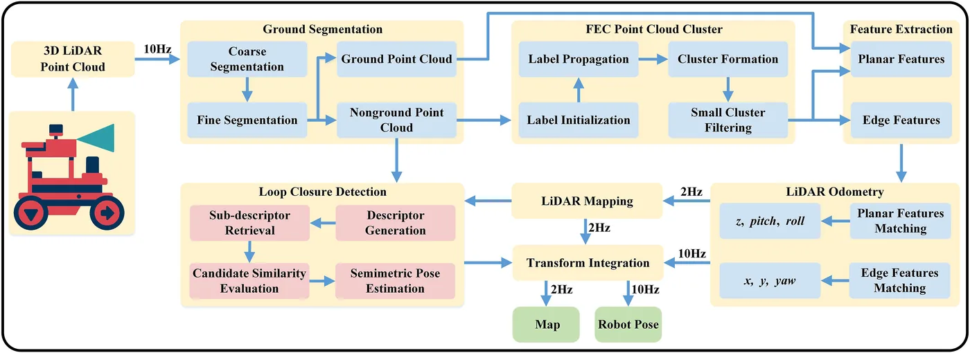
作者不提出新演算法,而是整合並依工地條件調整既有模組:兩階段地面分割(RANSAC 粗分割加法向量一致性精分割)取出樓板地面,快速歐幾里得分群(FEC)處理非地面點以抑制工人與機具等動態物,兩步配準以地面平面特徵估計 z、roll、pitch,再以非地面邊緣特徵估計 x、y、yaw,構成只用光達的里程計,最後以 Scan Context++ 迴圈偵測與位姿圖最佳化修正漂移。平台為搭載 RS-Helios-16P 16 線光達與 NVIDIA Jetson Xavier NX 的阿克曼轉向輪式機器人。以西安某醫院門診大樓的 Gazebo 模擬(1293 m)與同一棟施工中大樓的實地資料(1004 m)比較 F-LOAM 與 LeGO-LOAM,本方法 ATE RMSE 分別為 5.40 m 與 2.87 m,以圖面尺寸評估的實地地圖平均誤差為 0.79%;實地軌跡真值來源未說明。
本頁內容
System-integration paper: two-stage ground segmentation, FEC clustering of non-ground points, LeGO-LOAM-style two-step LiDAR-only registration and Scan Context++ loop closure with pose-graph optimization, run on a Jetson Xavier NX wheeled robot with an RS-Helios-16P; it beats F-LOAM and LeGO-LOAM in a Gazebo model (ATE RMSE 5.40 m over 1293 m) and on the same building's active site (2.87 m over 1004 m; 0.79% mean dimension error vs drawings), though the real-site ground-truth source is not described.
技術屬性
欄位內容為文獻擷取紀錄的原文用語(英文),以原文為據;「未查證」表示本研究尚未讀到該資訊,不代表該方法不具備此能力。
| 感測輸入 | 3D LiDAR RS-Helios-16P (16 beams, 10 Hz, +-15 deg vertical FOV, +-2 cm ranging)、nine-axis IMU at 200 Hz (recorded; the evaluated system is LiDAR-only)、camera (recorded; model not reported; not used by the method) |
|---|---|
| 原文測試平台 | wheeled UGV (Ackermann-steered construction robot base, teleoperated at 0.50 m/s on site)、simulation (Gazebo, robot moved at 1.00 m/s) |
| 狀態估計 | LiDAR-only feature-based odometry with two-step registration following LeGO-LOAM (ground planar features estimate z, roll and pitch; edge features from FEC-clustered non-ground points estimate x, y and yaw), scan-to-map mapping, and pose-graph optimization with Scan Context++ loop constraints (Sec. 3.1, Algorithm 1) |
| 資料關聯 | plane features from two-stage-segmented ground points (RANSAC fit on two low beams, 6 deg coarse threshold, 3 deg normal-consistency check) and edge features from FEC clusters of non-ground points (dth = 0.20 m, 30 to 50 point minimum cluster); scan-to-map feature alignment (Sec. 3.1, 3.3, 3.4) |
| 時間表示 | 原文未報告 |
| 去畸變 | 原文未報告 |
| 迴圈閉合 | Scan Context++ descriptor on ground-removed clustered points, run in a parallel thread (Sec. 3.5, Algorithm 1) |
| 全域最佳化 | pose-graph optimization fusing odometry and loop-closure constraints (Sec. 3.1, Algorithm 1) |
| 地圖表示 | global point cloud map built by scan-to-map feature alignment, saved as PCD (Sec. 3.1, Sec. 5.2) |
| 先驗資訊 | none for SLAM; CAD drawings of the building used to build the Gazebo world and as the dimension reference for map evaluation (Sec. 4.1, Sec. 5.2.2) |
| 可輸出幾何 | point cloud map (PCD) and TUM-format trajectory (Sec. 5.2) |
| 計算需求 | NVIDIA Jetson Xavier NX (6-core Carmel ARM v8.2, 384-core Volta GPU, 8 GB): 121.62 ms per frame, 81.75% CPU, 1866.52 MB memory; odometry 10 Hz, mapping 2 Hz (Sec. 3.2, Sec. 5.2.4, Table 8) |
使用設備
原文使用的感測器、運算硬體與載具(equipment)。型號保留原文寫法,連結到設備頁中同一型號的歸併名稱;角色依原文用途分為方法輸入、資料集感測器、執行運算平台、參考或真值量測(reference or ground truth)與比較對象設備。
| 類別 | 型號(原文寫法) | 角色 | 資料集 | 原文規格 | 出處 |
|---|---|---|---|---|---|
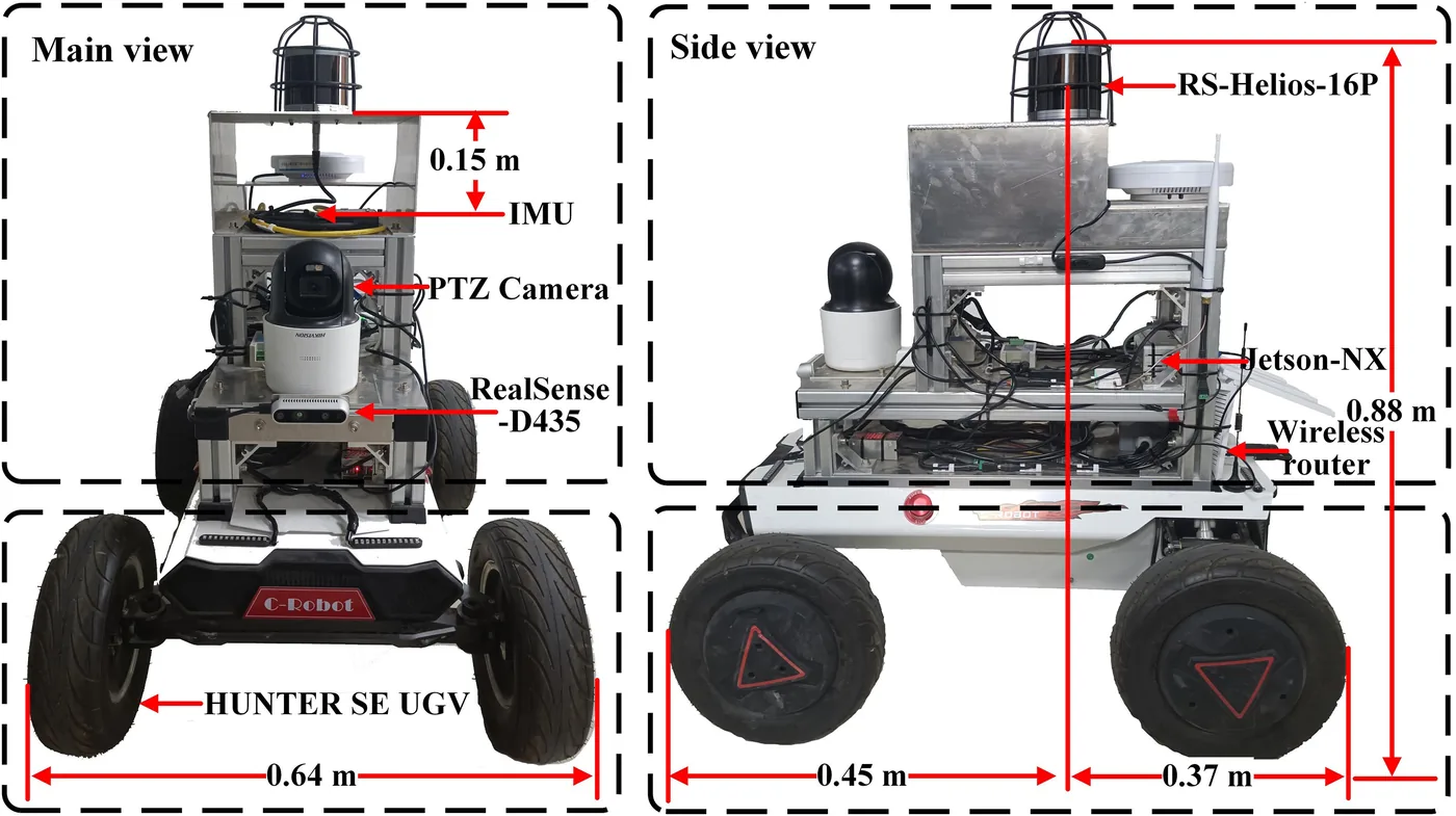
| LiDAR | RS-Helios-16P | 方法輸入 | 未標示 | 16 beams; 360 deg horizontal and +-15 deg vertical FOV; 0.4 deg horizontal and 2 deg vertical resolution; 10 Hz; +-2 cm ranging; 0.2 to 150 m; mounted horizontally at 0.88 m | (Feng et al., 2026, Sec. 3.2, Fig. 2) |
| 慣性量測單元(IMU) | nine-axis IMU | 資料集感測器 | authors' simulation and real-site rosbags | 200 Hz; mounted 0.15 m below the LiDAR; recorded but not used by the LiDAR-only method | (Feng et al., 2026, Sec. 3.2, Sec. 4.2, Sec. 5.1) |
| 載具平台 | construction robot experimental platform (Ackermann-steered wheeled base) | 方法輸入 | 未標示 | 24 V/30 Ah battery; front steering and rear drive via PWM motor controller; max 3.0 m/s; CAN bus to the Jetson; teleoperated with an Xbox 360 controller at 0.50 m/s on site | (Feng et al., 2026, Sec. 3.2, Sec. 5.1, Fig. 2) |
| 運算硬體 | NVIDIA Jetson Xavier NX | 執行運算平台 | 未標示 | 6-core Carmel ARM v8.2 CPU, 384-core Volta GPU, 8 GB LPDDR4x; Ubuntu 18.04, ROS Melodic | (Feng et al., 2026, Sec. 3.2, Sec. 5.2.4, Table 8) |
| 運算硬體 | laptop with Intel Core i7-11800H and NVIDIA GeForce RTX 3060 | 執行運算平台 | 未標示 | remote-control station connected over local Wi-Fi (Sec. 3.2); Sec. 4.1 states the Gazebo simulation ran on a computer with the same CPU and GPU, without saying it is this laptop; runtime figures in Table 8 are from the Jetson | (Feng et al., 2026, Sec. 3.2, Sec. 4.1) |
論文圖片
只收錄原文以開放授權(open license)釋出的圖片,並依授權條件標示出處、圖號、授權與修改方式。
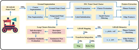
Fig. 1整合式光達 SLAM 系統架構與資料流(地面分割、FEC 分群、兩步配準、Scan Context++ 迴圈偵測)
出處:Feng et al., 2026,Fig. 1。授權:CC BY-NC 4.0。原始圖檔。修改:縮小至寬度不超過 1400 px,並轉存為 WebP 格式。
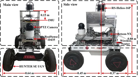
Fig. 2施工機器人硬體平台與主要設備(RS-Helios-16P、IMU、Jetson Xavier NX)
出處:Feng et al., 2026,Fig. 2。授權:CC BY-NC 4.0。原始圖檔。修改:縮小至寬度不超過 1400 px,並轉存為 WebP 格式。
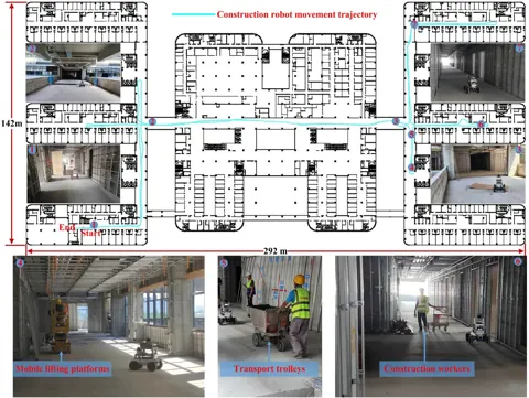
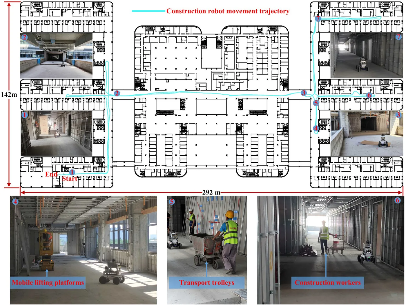
Fig. 10機器人在施工中醫院大樓工地收集資料的情形與軌跡
出處:Feng et al., 2026,Fig. 10。授權:CC BY-NC 4.0。原始圖檔。修改:縮小至寬度不超過 1400 px,並轉存為 WebP 格式。
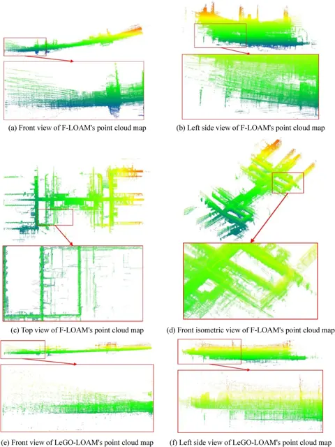
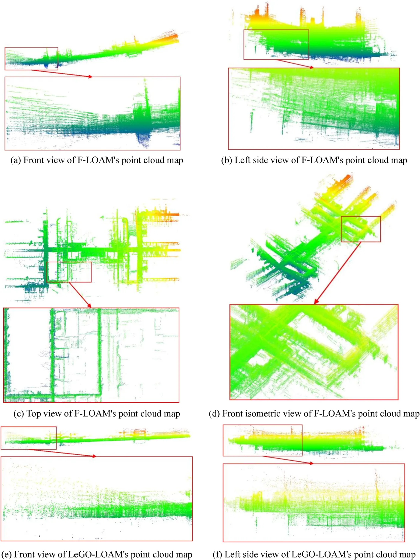
Fig. 13實地工地中三種 SLAM 方法點雲地圖的多視角比較(第一部分)
出處:Feng et al., 2026,Fig. 13。授權:CC BY-NC 4.0。原始圖檔。修改:縮小至寬度不超過 1400 px,並轉存為 WebP 格式。
作者報告的優勢與限制
優勢
- simulation ATE RMSE 5.40 m vs 12.33 m (LeGO-LOAM) and 20.27 m (F-LOAM) over 1293 m (Table 1)
- real-site ATE RMSE 2.87 m vs 7.97 m (LeGO-LOAM) and 19.95 m (F-LOAM) over 1004 m (Table 5)
- RMSE increased 10.00% with moving objects vs 19.95% (LeGO-LOAM) and 23.98% (F-LOAM) (Table 4)
- map dimension error averaged 0.79% on site vs 2.33% (LeGO-LOAM) and 5.21% (F-LOAM) (Tables 6, 8)
- runs on Jetson Xavier NX at 121.62 ms per frame, 7.20% slower than LeGO-LOAM (Table 8)
限制
- dynamic objects still degrade accuracy; semantic segmentation and object tracking left for future work (Sec. 4.2.4, Sec. 6)
- simulation omits dust, lighting and reflectivity effects and cannot reproduce Ackermann turning and stop-and-go motion (Sec. 4)
- real-site run limited to 1004 m by safety closures; teleoperated rather than autonomous (Sec. 5.1, Sec. 5.2.5)
- higher computational load: 121.62 ms per frame vs 65.63 ms for F-LOAM (Table 8)
- residual z-axis error remains after loop closure (Sec. 5.2.1)
- no comparison with tightly coupled LiDAR-inertial methods; loop-closure false positive and negative rates not quantified (Sec. 4.2, Sec. 6)
- (inference) real-site ground-truth source not described, and the proposed-method RMSE values in Tables 1, 4, 5 and 7 are inconsistent with their own mean and STD
營建工程相關證據
實地測試在西安某醫院門診大樓的施工中工地,當時處於機電安裝與裝修階段,現場有工人、機具、鷹架、升降平台與推車,部分區域因地坪施工封閉;機器人以遙控方式行走 1004 m(2067 s)。模擬以同一棟大樓 CAD 圖建立 Gazebo 場景(標準層 292 m x 142 m x 6 m,行走 1293 m)。實地軌跡真值來源未說明;地圖尺寸以施工圖尺寸為參考,並非獨立量測(Sec. 4、Sec. 5)。
原文驗證環境:模擬、施工中工地
報告的性能數據
以下是原文作者報告的性能數值(author-reported results),不是本研究重新量測的結果。每張圖只並列同一個比較組(comparison group,同一張表、同一組實驗設定)內的方法;不同比較組之間的數值不可直接比較,也不構成排名。
本方法共出現在 9 個比較組,合計 48 筆紀錄。以下列出本方法紀錄最多的 4 組,其餘 5 組列在最後,並連到性能比較頁。
Feng et al., 2026 · Table 2 本方法 10 筆
資料集與序列authors' Gazebo simulation of a hospital outpatient building (Xi'an) · A-B
表格設定(擷取紀錄原文):Wall-to-column distances in the SLAM map vs CAD drawing dimensions at 10 reference pairs; percentage error; map sizes omitted (Feng et al., 2026, Table 2)
Percentage error, site A-B,authors' Gazebo simulation of a hospital outpatient building (Xi'an) · A-B
只並列這張表在相同設定下報告的方法;以「本方法:」開頭者為本頁方法。失敗、未執行與未報告以標記呈現,不是 0。
按 Tab 進入圖表後,用上下方向鍵逐一瀏覽各類別,Esc 關閉提示框;也可開啟表格檢視閱讀全部數值。
這些是 Feng et al., 2026 在此表設定下報告的數值(author-reported results),只能在同一個比較組內對照,不代表方法在其他資料或設定下的表現。
資料來源作者報告值(Feng et al., 2026, Table 2)
| 方法(原文寫法) | 報告值 | 出處 |
|---|---|---|
| F-LOAM | 1.78% | (Feng et al., 2026, Table 2) |
| LeGO-LOAM | 0.51% | (Feng et al., 2026, Table 2) |
| Ours本方法原文提出 | 0.14% | (Feng et al., 2026, Table 2) |
Feng et al., 2026 · Table 6 本方法 10 筆
資料集與序列authors' real-site recording, hospital outpatient building (Xi'an) · A-B
表格設定(擷取紀錄原文):Wall-to-column distances in the SLAM map vs construction drawing dimensions at 10 reference pairs (drawings, not an independent survey); percentage error; map sizes omitted (Feng et al., 2026, Table 6)
Percentage error, site A-B,authors' real-site recording, hospital outpatient building (Xi'an) · A-B
只並列這張表在相同設定下報告的方法;以「本方法:」開頭者為本頁方法。失敗、未執行與未報告以標記呈現,不是 0。
按 Tab 進入圖表後,用上下方向鍵逐一瀏覽各類別,Esc 關閉提示框;也可開啟表格檢視閱讀全部數值。
這些是 Feng et al., 2026 在此表設定下報告的數值(author-reported results),只能在同一個比較組內對照,不代表方法在其他資料或設定下的表現。
資料來源作者報告值(Feng et al., 2026, Table 6)
| 方法(原文寫法) | 報告值 | 出處 |
|---|---|---|
| F-LOAM | 4.45% | (Feng et al., 2026, Table 6) |
| LeGO-LOAM | 0.4% | (Feng et al., 2026, Table 6) |
| Ours本方法原文提出 | 0.28% | (Feng et al., 2026, Table 6) |
Feng et al., 2026 · Table 1 本方法 5 筆
資料集與序列authors' Gazebo simulation of a hospital outpatient building (Xi'an) · simulation run, 1293 m in 1384 s, no loops in similar areas
表格設定(擷取紀錄原文):EVO ATE vs Gazebo ground truth; LiDAR-only methods; Min column omitted (Feng et al., 2026, Table 1)
ATE (m) Max,authors' Gazebo simulation of a hospital outpatient building (Xi'an) · simulation run, 1293 m in 1384 s, no loops in similar areas
只並列這張表在相同設定下報告的方法;以「本方法:」開頭者為本頁方法。失敗、未執行與未報告以標記呈現,不是 0。
按 Tab 進入圖表後,用上下方向鍵逐一瀏覽各類別,Esc 關閉提示框;也可開啟表格檢視閱讀全部數值。
這些是 Feng et al., 2026 在此表設定下報告的數值(author-reported results),只能在同一個比較組內對照,不代表方法在其他資料或設定下的表現。
資料來源作者報告值(Feng et al., 2026, Table 1)
| 方法(原文寫法) | 報告值 | 出處 |
|---|---|---|
| Ours本方法原文提出 | 7.35 m | (Feng et al., 2026, Table 1) |
| F-LOAM | 47.21 m | (Feng et al., 2026, Table 1) |
| LeGO-LOAM | 27.48 m | (Feng et al., 2026, Table 1) |
Feng et al., 2026 · Table 4 本方法 5 筆
資料集與序列authors' Gazebo simulation of a hospital outpatient building (Xi'an) · simulation run, 1293 m in 1384 s, no loops in similar areas, with dynamic objects
表格設定(擷取紀錄原文):EVO ATE in simulation with moving objects (worker cylinder 0.80 m/s, trolley 0.50 m/s, lifting platform 0.20 m/s); Min omitted (Feng et al., 2026, Table 4)
ATE (m) Max,authors' Gazebo simulation of a hospital outpatient building (Xi'an) · simulation run, 1293 m in 1384 s, no loops in similar areas, with dynamic objects
只並列這張表在相同設定下報告的方法;以「本方法:」開頭者為本頁方法。失敗、未執行與未報告以標記呈現,不是 0。
按 Tab 進入圖表後,用上下方向鍵逐一瀏覽各類別,Esc 關閉提示框;也可開啟表格檢視閱讀全部數值。
這些是 Feng et al., 2026 在此表設定下報告的數值(author-reported results),只能在同一個比較組內對照,不代表方法在其他資料或設定下的表現。
資料來源作者報告值(Feng et al., 2026, Table 4)
| 方法(原文寫法) | 報告值 | 出處 |
|---|---|---|
| Ours本方法原文提出 | 8.47 m | (Feng et al., 2026, Table 4) |
| F-LOAM | 58.92 m | (Feng et al., 2026, Table 4) |
| LeGO-LOAM | 34.48 m | (Feng et al., 2026, Table 4) |
其他比較組
來源
Feng et al., 2026
(2026)Integration and evaluation of a 3D LiDAR SLAM system for construction robots in large-scale public building sitesDevelopments in the Built Environment, 26, 100913
DOI 10.1016/j.dibe.2026.100913
同儕審查已出版已讀全文近十年