PlanarMesh
PlanarMesh 以「平面網格」表示場景:每個元素由一個平面(位置與法向量,以增量 PCA 更新)和落在該平面上的三角網格組成,頂點半徑近似局部曲率。每個新點經兩棵可動態插入的包圍體階層樹查詢:面相交搜尋(FIS)找出射線穿過的網格面以引入自由空間資訊,反向半徑搜尋(RRS)找出半徑涵蓋該點的邊界頂點;再以 95% 信賴區間的 z 檢定判定點在平面前方、平面上或後方,據以執行更新、擴張、新增、刪除、收縮與合併。輸出前依頂點半徑重新取樣並以 Delaunay 重新三角化,因此大平面用少量大三角形、細部用小三角形。位姿由外部 LiDAR 里程計提供。
本頁內容
An incremental LiDAR meshing system whose planar-mesh elements (a plane plus a mesh lying on it) are updated, grown, created, carved by free-space rays, shrunk and merged, with resolution set by per-vertex radii that track local curvature; poses come from an external odometry.
技術屬性
欄位內容為文獻擷取紀錄的原文用語(英文),以原文為據;「未查證」表示本研究尚未讀到該資訊,不代表該方法不具備此能力。
| 感測輸入 | 3D LiDAR |
|---|---|
| 原文測試平台 | not named in the paper; the text refers to walking speeds (a new scan every 0.5-1 m at normal walking speed; about 300 m at 1 m/s), which implies a person-carried scanner (inference) |
| 狀態估計 | 不適用 (poses from a separate LiDAR odometry such as FastLIO or VILENS; evaluation used ground-truth poses from registering each undistorted scan to the TLS map) |
| 資料關聯 | per-point Face Intersection Search and Reverse Radius Search on bounding volume hierarchies to find candidate planar-meshes |
| 時間表示 | 不適用 (externally supplied poses) |
| 去畸變 | delegated to the upstream LiDAR odometry (motion correction assumed in the supplied poses/scans) |
| 迴圈閉合 | none (elastic deformation for future loop closure mentioned as future work) |
| 全域最佳化 | none |
| 地圖表示 | planar-mesh (plane models combined with adaptive-resolution mesh), stored with a bounding volume hierarchy |
| 先驗資訊 | external poses |
| 可輸出幾何 | compact triangle mesh saved as binary PLY with 280-550 K faces (about 10 MB) on the tested sequences; before output each planar-mesh is resampled by vertex radius and re-triangulated with Delaunay, restoring concavity by discarding faces outside the original (Sec. III-F, IV-C) |
| 計算需求 | CPU only; about 0.4 s per scan on average (0.7 s peak), about 2 Hz, using all cores of a 28-core Intel i7 while baselines ran single-core at about 1 Hz (Sec. IV-A, IV-D) |
使用設備
原文使用的感測器、運算硬體與載具(equipment)。型號保留原文寫法,連結到設備頁中同一型號的歸併名稱;角色依原文用途分為方法輸入、資料集感測器、執行運算平台、參考或真值量測(reference or ground truth)與比較對象設備。
| 類別 | 型號(原文寫法) | 角色 | 資料集 | 原文規格 | 出處 |
|---|---|---|---|---|---|
| LiDAR | 64-beam LiDAR (model not named) | 資料集感測器 | Oxford Spires | beam count given only in the abstract, which ties the about 2 Hz rate to a 64-beam sensor; model not named; experiments used undistorted scans with ground-truth poses from registration to the TLS map (Sec. IV-A) | (Wang et al., 2025a, Abstract; Sec. III-A; Sec. IV-A) |
| 地面雷射掃描儀(TLS) | TLS (instrument not named) | 參考或真值量測 | Oxford Spires | highly accurate TLS point cloud map; every undistorted scan registered to it to obtain ground-truth poses; also the accuracy reference | (Wang et al., 2025a, Sec. IV-A; Fig. 6) |
| 運算硬體 | 28-core Intel i7 CPU | 執行運算平台 | 未標示 | no GPU acceleration; PlanarMesh used all cores, baselines a single core | (Wang et al., 2025a, Sec. IV-A) |
論文圖片
只收錄原文以開放授權(open license)釋出的圖片,並依授權條件標示出處、圖號、授權與修改方式。
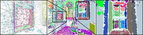
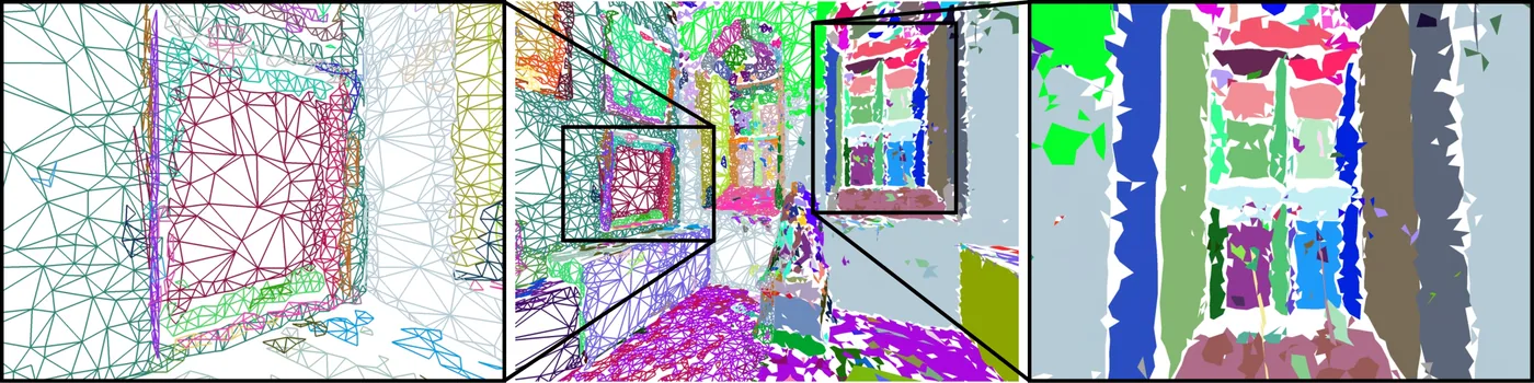
Fig. 1以平面網格重建畫框、整個房間與內凹窗框,不同平面以不同顏色表示
出處:Wang et al., 2025a,Fig. 1。授權:CC BY 4.0。原始圖檔。修改:縮小至寬度不超過 1400 px,並轉存為 WebP 格式。
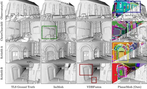
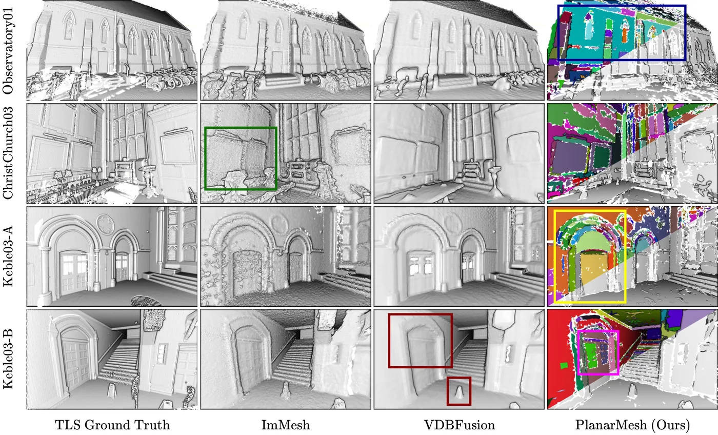
Fig. 6四段場景中 VDBFusion、ImMesh、TLS 真值與 PlanarMesh 的重建比較,標出門框與凹窗等細節
出處:Wang et al., 2025a,Fig. 6。授權:CC BY 4.0。原始圖檔。修改:縮小至寬度不超過 1400 px,並轉存為 WebP 格式。
作者報告的優勢與限制
優勢
- Accuracy on par with or better than ImMesh, VDBFusion and OctoMap on Oxford Spires against TLS ground truth, with meshes of 280-550 K faces versus 1.8-23 M and about 10 MB versus about 100 MB of accumulated LiDAR points (abstract, Sec. IV-B/C, Table I).
限制
- Memory grows until it exceeds available memory at about 300 scans (about 300 m at 1 m/s walking); submapping is future work (Sec. V).
- Real-time rate relies on all CPU cores while baselines were run on a single core, so runtime comparisons are not like-for-like (Sec. IV-A).
- Meshes show small holes and rugged edges; smoothing or plane intersection left for future work (Sec. IV-B).
- Deliberately biased toward precision over recall because tiny faces are dropped; recall 0.894 on Keble College 03 was the lowest of all methods (Sec. IV-B, Table I).
- No loop closure; listed as future work (Sec. V).
營建工程相關證據
以 Oxford Spires 資料集的 Christ Church 03、Keble College 03 與 Observatory 01 三條室內外序列評估,真值為高精度 TLS 點雲地圖,屬既有建築而非施工中工地。作者指出建成環境以平面為主,並認為此表示可支援平面圖生成與 BIM,但本文沒有實作(Sec. III-B)。未在營建場域驗證。
原文驗證環境:公開基準、已完工建築、獨立參考量測
報告的性能數據
以下是原文作者報告的性能數值(author-reported results),不是本研究重新量測的結果。每張圖只並列同一個比較組(comparison group,同一張表、同一組實驗設定)內的方法;不同比較組之間的數值不可直接比較,也不構成排名。
本方法共出現在 3 個比較組,合計 57 筆紀錄。
Wang et al., 2025a · Table II 本方法 28 筆
資料集與序列Oxford Spires · Christ Church 03
表格設定(擷取紀錄原文):Ablation on Christ Church 03: number of scans for which seed planar-meshes are retained (0, 1, 10, All); All is the default setting; same metrics as Table I. Note: the text in Sec. IV-E attributes 0.295 s and 5.9 MB to 1-scan retention, whereas the table lists them for 0 (Wang et al., 2025a, Table II)
Time (s) per scan,Oxford Spires · Christ Church 03
只並列這張表在相同設定下報告的方法;以「本方法:」開頭者為本頁方法。失敗、未執行與未報告以標記呈現,不是 0。
按 Tab 進入圖表後,用上下方向鍵逐一瀏覽各類別,Esc 關閉提示框;也可開啟表格檢視閱讀全部數值。
這些是 Wang et al., 2025a 在此表設定下報告的數值(author-reported results),只能在同一個比較組內對照,不代表方法在其他資料或設定下的表現。
資料來源作者報告值(Wang et al., 2025a, Table II)
| 方法(原文寫法) | 報告值 | 出處 |
|---|---|---|
| PlanarMesh, seed planar-meshes kept for 0 scans本方法原文提出硬體:28-core Intel i7 CPU, no GPU; PlanarMesh uses all cores, baselines one core each (Sec. IV-A) | 0.295 s | (Wang et al., 2025a, Table II) |
| PlanarMesh, seed planar-meshes kept for 1 scans本方法原文提出硬體:28-core Intel i7 CPU, no GPU; PlanarMesh uses all cores, baselines one core each (Sec. IV-A) | 0.347 s | (Wang et al., 2025a, Table II) |
| PlanarMesh, seed planar-meshes kept for 10 scans本方法原文提出硬體:28-core Intel i7 CPU, no GPU; PlanarMesh uses all cores, baselines one core each (Sec. IV-A) | 0.384 s | (Wang et al., 2025a, Table II) |
| PlanarMesh, seed planar-meshes kept for All scans本方法原文提出硬體:28-core Intel i7 CPU, no GPU; PlanarMesh uses all cores, baselines one core each (Sec. IV-A) | 0.313 s | (Wang et al., 2025a, Table II) |
Wang et al., 2025a · Table I 本方法 27 筆
表格設定(擷取紀錄原文):Oxford Spires; each method meshes individual scans with ground-truth poses (every undistorted scan registered to the TLS map); meshes sampled to the raw scan point count; distances to the TLS map after pre-filtering areas not seen by both; precision, recall and F-score at 0.1 m; OctoMap voxel 0.05 m, ImMesh and VDBFusion 0.1 m, baselines configured for about 1 Hz on one core, PlanarMesh on all 28 cores; file size as PLY binary; OctoMap has no faces or vertices (N/A) (Wang et al., 2025a, Table I)
Per-Scan Time (s),Oxford Spires · Christ Church 03 (about 307 m)
只並列這張表在相同設定下報告的方法;以「本方法:」開頭者為本頁方法。失敗、未執行與未報告以標記呈現,不是 0。
按 Tab 進入圖表後,用上下方向鍵逐一瀏覽各類別,Esc 關閉提示框;也可開啟表格檢視閱讀全部數值。
這些是 Wang et al., 2025a 在此表設定下報告的數值(author-reported results),只能在同一個比較組內對照,不代表方法在其他資料或設定下的表現。
資料來源作者報告值(Wang et al., 2025a, Table I)
| 方法(原文寫法) | 報告值 | 出處 |
|---|---|---|
| VDBFusion硬體:28-core Intel i7 CPU, no GPU; PlanarMesh uses all cores, baselines one core each (Sec. IV-A) | 0.871 s | (Wang et al., 2025a, Table I) |
| ImMesh硬體:28-core Intel i7 CPU, no GPU; PlanarMesh uses all cores, baselines one core each (Sec. IV-A) | 0.724 s | (Wang et al., 2025a, Table I) |
| PlanarMesh (Ours)本方法原文提出硬體:28-core Intel i7 CPU, no GPU; PlanarMesh uses all cores, baselines one core each (Sec. IV-A) | 0.392 s | (Wang et al., 2025a, Table I) |
| OctoMap硬體:28-core Intel i7 CPU, no GPU; PlanarMesh uses all cores, baselines one core each (Sec. IV-A) | 0.432 s | (Wang et al., 2025a, Table I) |
Wang et al., 2025a · Text Sec.IV-D 本方法 2 筆
資料集與序列Oxford Spires · Christ Church 03
表格設定(擷取紀錄原文):Per-scan processing time of PlanarMesh on Christ Church 03 (Fig. 7 stacked plot summarised in text); values stated in text, not read off the plot (Wang et al., 2025a, Text Sec.IV-D)
average processing time per scan (about),Oxford Spires · Christ Church 03
這張表在此指標與資料序列只列出本方法一筆,沒有可並列的其他方法,因此不畫圖,數值與出處見下表。這是 Wang et al., 2025a 在此表設定下報告的數值(author-reported results),不代表方法在其他資料或設定下的表現。
| 方法(原文寫法) | 報告值 | 出處 |
|---|---|---|
| PlanarMesh本方法原文提出硬體:28-core Intel i7 CPU, no GPU; PlanarMesh uses all cores, baselines one core each (Sec. IV-A) | 0.4 s | (Wang et al., 2025a, Sec. IV-D) |
來源
Wang et al., 2025a
(2025)PlanarMesh: Building Compact 3D Meshes from LiDAR using Incremental Adaptive Resolution Reconstruction2025 IEEE/RSJ International Conference on Intelligent Robots and Systems (IROS), pp. 15726-15733
DOI 10.1109/iros60139.2025.11246204arXiv 2510.13599程式碼
同儕審查已出版已讀全文近十年查證後修正
相關版本
- 預印本:arXiv:2510.13599 https://arxiv.org/abs/2510.13599
程式碼:https://github.com/ori-drs/planar_mesh(授權:GPL-3.0 (repository LICENSE.txt))。有公開程式碼不等於已被重現,也不代表目前版本與論文版本相同。