VDBFusion
VDBFusion 以 OpenVDB 的階層稀疏體積結構儲存 TSDF,提供 C++ 與 Python 介面;權重函數可在執行時以 lambda 傳入,空間雕刻(space carving)可選擇開關,網格擷取可設最小權重門檻。作者說明截斷距離大有助抑制雜訊,但會造成薄面增厚;關閉空間雕刻較快,但會留下動態物體殘影。
本頁內容
A TSDF integration library on OpenVDB with runtime-selectable weighting, optional space carving and a minimum-weight mesh threshold, running on a single CPU core.
技術屬性
欄位內容為文獻擷取紀錄的原文用語(英文),以原文為據;「未查證」表示本研究尚未讀到該資訊,不代表該方法不具備此能力。
| 感測輸入 | 3D LiDAR、RGB-D |
|---|---|
| 原文測試平台 | vehicle、handheld (Newer College, qualitative only)、simulation (ICL-NUIM synthetic RGB-D, qualitative only) |
| 狀態估計 | 不適用 (poses supplied; points assumed in the global frame) |
| 資料關聯 | ray casting of points into a TSDF within the truncation distance |
| 時間表示 | 不適用 |
| 去畸變 | delegated to dataset-specific data loaders (system section) |
| 迴圈閉合 | 不適用 |
| 全域最佳化 | none |
| 地圖表示 | TSDF stored as two OpenVDB sparse grids (signed distance and weight); VDB leaf blocks are typically 8 x 8 x 8 voxels in a fixed-depth tree; truncation distance 3 voxels in the experiments; optional space carving; no occupancy probabilities (Sec. 3, 4.2, 4.3, 5) |
| 先驗資訊 | external poses |
| 可輸出幾何 | triangle mesh via marching cubes adapted from Open3D to VDB, with optional hole filling (Curless and Levoy) and a runtime min_weight threshold that also removes dynamic objects; TSDF and weight grids saved as VDB files with lossless compression (Sec. 4.6, 5.3) |
| 計算需求 | single CPU core without multithreading (Intel Xeon W-2145, 8 cores at 3.70 GHz, 32 GB RAM, GCC 9.3.0); KITTI 07 at 10 cm voxels 19.57 fps without and 1.37 fps with space carving; Cow and Lady at 2 mm voxels 14.14 fps and 0.84 fps (Sec. 5, Table 2) |
使用設備
原文使用的感測器、運算硬體與載具(equipment)。型號保留原文寫法,連結到設備頁中同一型號的歸併名稱;角色依原文用途分為方法輸入、資料集感測器、執行運算平台、參考或真值量測(reference or ground truth)與比較對象設備。
| 類別 | 型號(原文寫法) | 角色 | 資料集 | 原文規格 | 出處 |
|---|---|---|---|---|---|
| LiDAR | 64-beam rotating Velodyne LiDAR (exact model not named) | 資料集感測器 | KITTI Odometry | mounted on a car roof; experiments used ranges 2-70 m and 10 cm voxels | (Vizzo et al., 2022, Sec. 5; Sec. 5.6.1) |
| LiDAR | 64-beam Ouster sensor (model not named) | 資料集感測器 | Newer College | hand-held device through New College, Oxford; only LiDAR data used; qualitative result | (Vizzo et al., 2022, Sec. 5.6.2) |
| LiDAR | 32-beam Velodyne LiDAR scanner (model not named) | 資料集感測器 | nuScenes | car roof; Boston and Singapore; scene-0061; qualitative result | (Vizzo et al., 2022, Sec. 5.6.3) |
| LiDAR | Velodyne HDL-64E | 資料集感測器 | Apollo-SouthBay | car roof; Columbia Park sequence; qualitative result | (Vizzo et al., 2022, Sec. 5.6.4) |
| RGB-D 相機 | Microsoft Kinect | 資料集感測器 | TUM RGB-D | colour and depth at 30 Hz, 640 x 480; freiburg1_xyz sequence; qualitative result | (Vizzo et al., 2022, Sec. 5.6.6) |
| RGB-D 相機 | RGB-D camera of the Cow and Lady dataset (model not named) | 資料集感測器 | Cow and Lady | points within 0.1-5 m used, 2 mm voxels, truncation 3 voxels | (Vizzo et al., 2022, Sec. 5) |
| RGB-D 相機 | synthetic RGB-D depth maps (ICL-NUIM Living room, no simulated noise) | 資料集感測器 | ICL-NUIM | depth maps converted to point clouds with ground-truth camera poses; qualitative result | (Vizzo et al., 2022, Sec. 5.6.5) |
| 運算硬體 | Intel Xeon W-2145 | 執行運算平台 | 未標示 | 8 cores at 3.70 GHz, 32 GB RAM, GNU/Linux 64-bit, GCC 9.3.0; every method run without multithreading | (Vizzo et al., 2022, Sec. 5) |
| 其他 | integrated navigation system (model not named) | 參考或真值量測 | Apollo-SouthBay | source of the ground-truth poses used for the Apollo-SouthBay example | (Vizzo et al., 2022, Sec. 5.6.4) |
| 其他 | high-resolution scanner (type and model not named) | 參考或真值量測 | Cow and Lady | reference point cloud supplied with the Cow and Lady dataset, used for the accuracy evaluation | (Vizzo et al., 2022, Sec. 5.4) |
論文圖片
只收錄原文以開放授權(open license)釋出的圖片,並依授權條件標示出處、圖號、授權與修改方式。
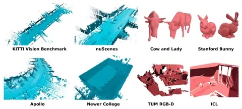
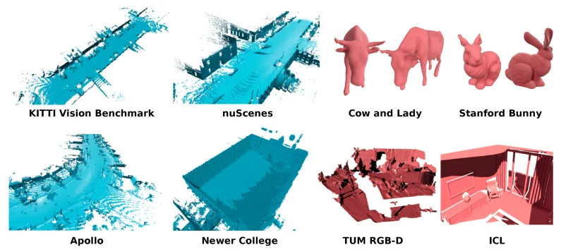
Figure 1VDBFusion 在多個公開 LiDAR 與 RGB-D 資料集的重建結果(藍色為 LiDAR、紅色為 RGB-D)
出處:Vizzo et al., 2022,Figure 1。授權:CC BY 4.0。原始圖檔。修改:轉存為 WebP 格式。
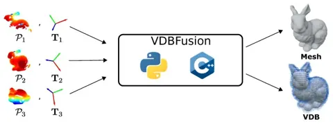
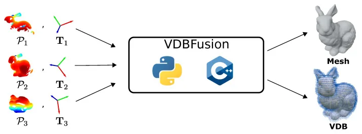
Figure 3系統總覽:輸入點雲與位姿,整合為稀疏 TSDF 後輸出網格或 VDB 資料
出處:Vizzo et al., 2022,Figure 3。授權:CC BY 4.0。原始圖檔。修改:轉存為 WebP 格式。
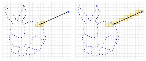
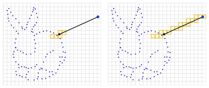
Figure 6有無空間雕刻時沿射線更新的體素範圍差異
出處:Vizzo et al., 2022,Figure 6。授權:CC BY 4.0。原始圖檔。修改:轉存為 WebP 格式。
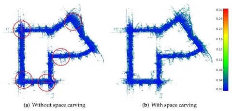
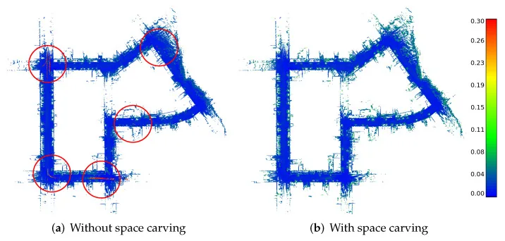
Figure 12KITTI 07 地圖逐點誤差:未雕刻時動態物體殘影,雕刻後動態物體移除但車緣也被削去
出處:Vizzo et al., 2022,Figure 12。授權:CC BY 4.0。原始圖檔。修改:轉存為 WebP 格式。
作者報告的優勢與限制
優勢
- Integrates 64-beam LiDAR scans at 20 fps on a single CPU core without space carving (abstract; 19.57 fps on KITTI 07, Table 2).
- Only three mapping parameters versus fourteen in Voxblox (Sec. 4.1, 4.5).
- Smallest RAM footprint among tested variants: 847.0 MB on KITTI 07 versus 1.12 GB for Octomap and 2.95 GB for raw points (Table 4).
- Mean point-to-point error 0.023 m (std 0.022 m) on KITTI 07 with space carving, versus 0.033 m for Octomap and 0.497 m for Voxblox (Table 6).
- Python API nearly as fast as C++ (18.93 versus 19.57 fps on KITTI 07, Table 3); ten students built a working pipeline in under 1 h, 40 min on average (Sec. 5.5).
限制
- Large truncation distances thicken thin surfaces; small ones are sensitive to sensor noise (Sec. 4.5).
- Space carving removes dynamic objects but cuts the rate to 1.37 fps on KITTI 07 and 0.84 fps on Cow and Lady, below Octomap's 1.05 fps there (Sec. 4.5, Table 2).
- Space carving also removed parts of the static scene at car boundaries (Fig. 12).
- (inference) The KITTI 07 accuracy reference is built by aggregating the KITTI LiDAR scans of the same sequence without downsampling and removing dynamic objects with SemanticKITTI labels (Sec. 5.4), so accuracy is not measured against an independent instrument; the authors do not discuss this.
- The authors' Voxblox results do not match the original publication; they suspect a numerical error in Voxblox's transformation library, which weakens that comparison (Sec. 5.4).
- No probabilistic occupancy model; an exported mesh cannot be updated after it is stored (Sec. 4.3, 5.3).
營建工程相關證據
定量評估只用 KITTI 07(車載 LiDAR,準確度參考是同一序列的累積點雲)與 Cow and Lady(室內 RGB-D,參考點雲來自高解析度掃描儀),未涉及營建;截斷距離造成薄面增厚、空間雕刻會削去靜態物體邊緣等說明,與營建薄構件及臨時構件的量測直接相關(推論)。
原文驗證環境:公開基準
報告的性能數據
以下是原文作者報告的性能數值(author-reported results),不是本研究重新量測的結果。每張圖只並列同一個比較組(comparison group,同一張表、同一組實驗設定)內的方法;不同比較組之間的數值不可直接比較,也不構成排名。
本方法共出現在 14 個比較組,合計 110 筆紀錄。以下列出本方法紀錄最多的 4 組,其餘 10 組列在最後,並連到性能比較頁。
Wang et al., 2025a · Table I 本方法 27 筆
表格設定(擷取紀錄原文):Oxford Spires; each method meshes individual scans with ground-truth poses (every undistorted scan registered to the TLS map); meshes sampled to the raw scan point count; distances to the TLS map after pre-filtering areas not seen by both; precision, recall and F-score at 0.1 m; OctoMap voxel 0.05 m, ImMesh and VDBFusion 0.1 m, baselines configured for about 1 Hz on one core, PlanarMesh on all 28 cores; file size as PLY binary; OctoMap has no faces or vertices (N/A) (Wang et al., 2025a, Table I)
Per-Scan Time (s),Oxford Spires · Christ Church 03 (about 307 m)
只並列這張表在相同設定下報告的方法;以「本方法:」開頭者為本頁方法。失敗、未執行與未報告以標記呈現,不是 0。
按 Tab 進入圖表後,用上下方向鍵逐一瀏覽各類別,Esc 關閉提示框;也可開啟表格檢視閱讀全部數值。
這些是 Wang et al., 2025a 在此表設定下報告的數值(author-reported results),只能在同一個比較組內對照,不代表方法在其他資料或設定下的表現。
資料來源作者報告值(Wang et al., 2025a, Table I)
| 方法(原文寫法) | 報告值 | 出處 |
|---|---|---|
| VDBFusion本方法硬體:28-core Intel i7 CPU, no GPU; PlanarMesh uses all cores, baselines one core each (Sec. IV-A) | 0.871 s | (Wang et al., 2025a, Table I) |
| ImMesh硬體:28-core Intel i7 CPU, no GPU; PlanarMesh uses all cores, baselines one core each (Sec. IV-A) | 0.724 s | (Wang et al., 2025a, Table I) |
| PlanarMesh (Ours)原文提出硬體:28-core Intel i7 CPU, no GPU; PlanarMesh uses all cores, baselines one core each (Sec. IV-A) | 0.392 s | (Wang et al., 2025a, Table I) |
| OctoMap硬體:28-core Intel i7 CPU, no GPU; PlanarMesh uses all cores, baselines one core each (Sec. IV-A) | 0.432 s | (Wang et al., 2025a, Table I) |
Pan et al., 2025 · Table II 本方法 16 筆
表格設定(擷取紀錄原文):Oxford Spires surface reconstruction against the millimetre-accurate Leica RTC360 TLS reference map; localization disabled and ground-truth poses used for all methods; OpenMVS and Nerfacto results taken from the benchmark (offline batch); meshes at 0.1 m resolution; F-score threshold 0.1 m; precision and recall columns not extracted (Pan et al., 2025, Table II)
Accuracy error,Oxford Spires · Blenheim Palace 05
只並列這張表在相同設定下報告的方法;以「本方法:」開頭者為本頁方法。失敗、未執行與未報告以標記呈現,不是 0。
按 Tab 進入圖表後,用上下方向鍵逐一瀏覽各類別,Esc 關閉提示框;也可開啟表格檢視閱讀全部數值。
這些是 Pan et al., 2025 在此表設定下報告的數值(author-reported results),只能在同一個比較組內對照,不代表方法在其他資料或設定下的表現。
資料來源作者報告值(Pan et al., 2025, Table II)
| 方法(原文寫法) | 報告值 | 出處 |
|---|---|---|
| OpenMVS [5] (offline) | 0.126 m | (Pan et al., 2025, Table II) |
| Nerfacto [62] (offline) | 0.302 m | (Pan et al., 2025, Table II) |
| GSS [11] | 0.204 m | (Pan et al., 2025, Table II) |
| VDB-Fusion [67]本方法 | 0.098 m | (Pan et al., 2025, Table II) |
| PIN-SLAM [51] | 0.078 m | (Pan et al., 2025, Table II) |
| PINGS (Ours)原文提出 | 0.072 m | (Pan et al., 2025, Table II) |
Zhu et al., 2025 · Table V 本方法 10 筆
表格設定(擷取紀錄原文):Mesh quality with ground-truth poses for all methods, voxel size 0.1 m, settings of SHINE-Mapping; distances in cm; completion ratio and F-score in % at 10 cm (Mai City) and 20 cm (Newer College) (Zhu et al., 2025, Table V)
Comp. (cm), completion,Mai City · Mai City
只並列這張表在相同設定下報告的方法;以「本方法:」開頭者為本頁方法。失敗、未執行與未報告以標記呈現,不是 0。
按 Tab 進入圖表後,用上下方向鍵逐一瀏覽各類別,Esc 關閉提示框;也可開啟表格檢視閱讀全部數值。
這些是 Zhu et al., 2025 在此表設定下報告的數值(author-reported results),只能在同一個比較組內對照,不代表方法在其他資料或設定下的表現。
資料來源作者報告值(Zhu et al., 2025, Table V)
| 方法(原文寫法) | 報告值 | 出處 |
|---|---|---|
| VDB Fusion [28]本方法 | 6.9 cm | (Zhu et al., 2025, Table V (VoR)) |
| Puma [13] | 32 cm | (Zhu et al., 2025, Table V (VoR)) |
| SHINE-Mapping [30] | 3.2 cm | (Zhu et al., 2025, Table V (VoR)) |
| SLAMesh [14] | 7.5 cm | (Zhu et al., 2025, Table V (VoR)) |
| Ours原文提出 | 2.5 cm | (Zhu et al., 2025, Table V (VoR)) |
Deng et al., 2023 · Table 1 本方法 8 筆
表格設定(擷取紀錄原文):Simultaneous odometry and mapping; SHINE-Mapping and VDBFusion are fed KISS-ICP poses, NeRF-LOAM is shown with KISS-ICP poses and with its own odometry, Puma uses its own odometry; same voxel size for all; Newer College uses one of every five scans; accuracy, completion and Chamfer-L1 units not stated here (the same Newer College values are labelled cm in PIN-SLAM Table XI) (Deng et al., 2023, Table 1)
Map. Acc.,MaiCity
只並列這張表在相同設定下報告的方法;以「本方法:」開頭者為本頁方法。失敗、未執行與未報告以標記呈現,不是 0。
按 Tab 進入圖表後,用上下方向鍵逐一瀏覽各類別,Esc 關閉提示框;也可開啟表格檢視閱讀全部數值。
這些是 Deng et al., 2023 在此表設定下報告的數值(author-reported results),只能在同一個比較組內對照,不代表方法在其他資料或設定下的表現。
資料來源作者報告值(Deng et al., 2023, Table 1)
| 方法(原文寫法) | 報告值 | 出處 |
|---|---|---|
| SHINE [50] with KissICP poses | 5.75 | (Deng et al., 2023, Table 1) |
| Vdbfusion [37] with KissICP poses本方法 | 4.95 | (Deng et al., 2023, Table 1) |
| Ours with KissICP poses原文提出 | 4.16 | (Deng et al., 2023, Table 1) |
| Puma [36] with own odometry | 7.89 | (Deng et al., 2023, Table 1) |
| Ours with own odometry原文提出 | 5.69 | (Deng et al., 2023, Table 1) |
其他比較組
來源
Vizzo et al., 2022
(2022)VDBFusion: Flexible and Efficient TSDF Integration of Range Sensor DataSensors, 22(3):1296
同儕審查已出版已讀全文近十年MDPI
相關版本
- 程式碼釋出:PRBonn/vdbfusion https://github.com/PRBonn/vdbfusion
程式碼:https://github.com/PRBonn/vdbfusion(授權:MIT (repository LICENSE))。有公開程式碼不等於已被重現,也不代表目前版本與論文版本相同。